Knockholt railway station
| Knockholt | |
|---|---|
 | |
 Knockholt Location of Knockholt in Greater London | |
| Location | Chelsfield |
| Local authority | London Borough of Bromley |
| Managed by | Southeastern |
| Station code | KCK |
| DfT category | E |
| Number of platforms | 2 |
| Fare zone | 6 |
| National Rail annual entry and exit | |
| 2012–13 |
|
| 2013–14 |
|
| 2014–15 |
|
| 2015–16 |
|
| 2016–17 |
|
| Railway companies | |
| Original company | South Eastern Railway |
| Pre-grouping | South Eastern and Chatham Railway |
| Post-grouping | Southern Railway |
| Key dates | |
| 1 May 1876 | Opened as Halstead for Knockholt |
| 1 October 1900 | renamed Knockholt |
| Other information | |
| Lists of stations | |
| External links | |
| WGS84 | 51°20′45″N 0°07′51″E / 51.3459°N 0.1307°ECoordinates: 51°20′45″N 0°07′51″E / 51.3459°N 0.1307°E |
|
| |
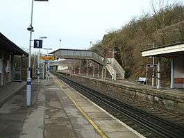
Knockholt railway station is on the South Eastern Main Line, located in the London Borough of Bromley, south-east London. It is 16 miles 44 chains (26.6 km) down the line from London Charing Cross and is situated between Chelsfield and Dunton Green stations. It is in Travelcard Zone 6 and is located next to the Greater London boundary with the Kent district of Sevenoaks. The boundary is the farm bridge at the southern end of the platforms.
Location
The station is 4.8 km (3.0 mi) north-northeast of the village of Knockholt but closer to several other settlements. The station serves several small communities in the Sevenoaks district in addition to Knockholt; Badgers Mount 1.3 km (0.81 mi) to the southeast, Well Hill 1.3 km (0.81 mi) northeast, and Halstead 2.2 km (1.4 mi) south. Within the Bromley borough Pratts Bottom is only 2 km (1.2 mi) west-southwest; and also Chelsfield (although having its own railway station, is in parts closer to Knockholt station) at about 2.7 km (1.7 mi) to the north and west. To avoid confusion with Halstead in Essex it was named after the next closest village.
Services
The typical off-peak service from the station is two trains per hour southbound to Sevenoaks and two trains per hour northbound to London Charing Cross, calling at all stations to Hither Green and then running fast to London Bridge.
| Preceding station | Following station | |||
|---|---|---|---|---|
| Chelsfield | Southeastern South Eastern Main Line Stopping Services |
Dunton Green | ||
History
When the South Eastern Railway (SER) opened their "cut off" line through Orpington, Sevenoaks to Tonbridge in 1868, there was no station between Chelsfield and Dunton Green. A Knockholt Vestry meeting in March 1871 resolved to request the SER to build a station for Knockholt but this request was initially refused. Eventually, the SER agreed to provide a station if a £3,000 contribution was provided by "local parties," (equivalent to £260,000 in 2016).[2] This was raised and "Halstead for Knockholt" (the station being much closer to Halstead than Knockholt) was opened in 1876.[3]
Between 1887 and 1915 a twice daily bus service operated from Knockholt village to the station.
In 1899 the SER joined with its arch rival to form the South Eastern and Chatham Railway (SECR). Alfred Smithers, who had moved to Knockholt in 1881, became deputy chairman of the SECR. At the strong suggestion of Smithers, the station name was changed to "Knockholt" in 1900 to avoid the confusion which had arisen with Halstead Station in Essex (and coincidentally giving Smithers a local station named after his village).
Buses
The station is served by the 431 bus operated by Go Coach between Orpington and Sevenoaks Town Centres
References
- 1 2 3 4 5 "Station usage estimates". Rail statistics. Office of Rail Regulation. Please note: Some methodology may vary year on year.
- ↑ UK Retail Price Index inflation figures are based on data from Clark, Gregory (2017). "The Annual RPI and Average Earnings for Britain, 1209 to Present (New Series)". MeasuringWorth. Retrieved November 6, 2017.
- ↑ A History Of Knockholt, pp.128-130, by David Waldron Smithers, ISBN 0-9513500-4-8.
External links
| Wikimedia Commons has media related to Knockholt railway station. |
- Train times and station information for Knockholt railway station from National Rail