Pratt's Bottom
| Pratt's Bottom | |
|---|---|
 | |
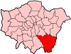
 Pratt's Bottom Pratt's Bottom shown within Greater London | |
| OS grid reference | TQ471622 |
| London borough | |
| Ceremonial county | Greater London |
| Region | |
| Country | England |
| Sovereign state | United Kingdom |
| Post town | ORPINGTON |
| Postcode district | BR6 |
| Dialling code | 01689 |
| Police | Metropolitan |
| Fire | London |
| Ambulance | London |
| EU Parliament | London |
| UK Parliament | |
| London Assembly | |
Pratt's Bottom is a village in Greater London within the London Borough of Bromley. It is south of its parent parish of Orpington, and is close to the border with Kent.
It has frequently been noted on lists of unusual place names.[1]
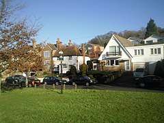
It is a small village, consisting of a main road (Rushmore Hill) on which is situated a school, a village shop (the post office was closed as part of the widespread branch closures of June 2008) and the Bulls Head pub, two small churches and a few side roads. There is a village hall behind the green.
History
A "bottom" in this context means a valley or hollow, and the Pratts were a noble family once seated in the area.[2] Pratt's Bottom formed part of the ancient, and later civil, parish of Chelsfield in Kent[3] and was part of the Bromley Rural District from 1896.[3] The parish was abolished in 1934 and the village became part of Orpington Urban District.[4] In 1965 it was transferred to Greater London, to form part of the London Borough of Bromley.[4]
A tollgate stood in the village for many years. The turnpike cottage was demolished in the 1930s but is still seen as emblematic of the village, so much so that it is the basis of the recent village sign placed on the green. Sue Short has written a book about the history of the village titled Pratts Bottom: A Journey Through Life.[5]
Pratt's Bottom was declared to be the 'sister city' of Wellington, New Zealand in 2009 by then-Mayor, Kerry Prendergast .
Local Government Elections
| Party | Candidate | Votes | % | ± | |
|---|---|---|---|---|---|
| Conservative | Mike Botting | 2,928 | 21.6 | ||
| Conservative | Angela Page | 2,770 | 20.5 | ||
| Conservative | Samaris Huntington-Thresher | 2,715 | 20.1 | ||
| Labour | Margaret Mills | 809 | 6.0 | ||
| Labour | Stephen Richardson | 748 | 5.5 | ||
| Labour | Peter Moore | 726 | 5.4 | ||
| Liberal Democrat | Gerda Loosemore-Reppen | 674 | 5.0 | ||
| Liberal Democrat | John Bray | 620 | 4.6 | ||
| Green | Daniel Sloan | 616 | 4.6 | ||
| Liberal Democrat | Jonathan Webber | 434 | 3.2 | ||
| UKIP | Michael Porter | 246 | 1.8 | ||
| UKIP | Brian Philp | 244 | 1.8 | ||
| Turnout | 13,530 | 42.1 | |||
| Conservative hold | Swing | ||||
| Conservative hold | Swing | ||||
| Conservative hold | Swing | ||||
Transport
Pratts Bottom is served by Transport for London bus routes R5 and R10 with services to Orpington via Green Street Green and to Knockholt. The nearest rail link to Pratts Bottom is at Knockholt station.
Nearby Areas
Pratts Bottom borders Chelsfield to the north and north east, Badgers Mount to the east, Halstead to the south east, Knockholt to the south and south west, Hazelwood to the west and Green Street Green to the north west.
References
- ↑ Lyall, Sarah (22 January 2009). "No Snickering: That Road Sign Means Something Else". The New York Times. Retrieved 13 July 2014.
- ↑ Mills, A., Oxford Dictionary of London Place Names, (2001)
- 1 2 Vision of Britain - Chelsfield parish (historic boundaries Archived 1 October 2007 at the Wayback Machine.)
- 1 2 Vision of Britain - Orpington parish Archived 11 March 2007 at the Wayback Machine.
- ↑ Short, Sue (2009). Pratts Bottom: A Journey Through Life. BPR Publishers. ISBN 978-0-9554336-1-0.
External links
![]()