Kiowa Rural Township, Kiowa County, Kansas
| Kiowa Rural Township | |
|---|---|
| Township | |
 Map of Kiowa County | |
| Coordinates: 37°25′46″N 99°29′33″W / 37.42944°N 99.49250°WCoordinates: 37°25′46″N 99°29′33″W / 37.42944°N 99.49250°W | |
| Country | United States |
| State | Kansas |
| County | Kiowa |
| Area | |
| • Total | 722.39 sq mi (1,871.0 km2) |
| • Land | 722.19 sq mi (1,870.5 km2) |
| • Water | 0.2 sq mi (0.5 km2) 0.03% |
| Elevation[1] | 2,182 ft (665 m) |
| Population (2000) | |
| • Total | 3,278 |
| • Density | 4.538/sq mi (1.752/km2) |
| Time zone | UTC-6 (Central (CST)) |
| • Summer (DST) | UTC-5 (CDT) |
| Area code(s) | 620 |
| GNIS feature ID | 0470707 |
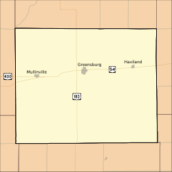
Kiowa Rural Township is the sole township in Kiowa County, Kansas, United States. The population was 3,278 at the 2000 census, out of whom 2,346 lived in one of the township's three cities and 813 lived in unincorporated areas of the township.[2] Kiowa Rural Township's boundaries are identical to those of Kiowa County: there are no other townships in the county, and none of the county's cities are governmentally independent.[3]
History
Kiowa Rural Township was once named simply "Kiowa Township."[1] It has not always been the only township in the county: until 1980-01-01, when all existing townships in the county were dissolved,[4] there was also Martin Township, located near Mullinville in the western part of the county,[5] and Wellsford Township (previously Dowell Township), located near Haviland in the eastern part of the county.[6] Even these three townships were significantly expanded from past years; in 1940, Kiowa County was composed of fifteen townships: Brenham, Butler, Center, Garfield, Glick, Highland, Kiowa, Lincoln, Martin, Reeder, Union, Ursula, Valley, Wellsford, and Westland.[7] Although it includes the territories of those former townships, Kiowa Rural Township itself is not important to local government, having become inactive.[1]
Geography
Because Kiowa Rural Township is coterminous with the county, its statistics are similar to the county's. It covers an area of 722.39 square miles (1871.0 square kilometers);[8] of this, 0.2 square miles (0.5 square kilometers) or 0.03%, is water.[9]
Six cemeteries are located in the township: Belvidere,[10] Boles,[11] Fairview,[12] Haviland,[13] Hillcrest,[14] and McKinley.[15]
Communities
Seven populated places are located in Kiowa Rural Township:[1]
Adjacent townships
- South Brown Township, Edwards County — northern border, west
- Franklin Township, Edwards County — northern border, central
- Lincoln Township, Edwards County — northern border, east
- Township 8, Pratt County — northeastern corner
- Township 9, Pratt County — eastern border, north
- Township 10, Pratt County — eastern border, central
- Turkey Creek Township, Barber County — eastern border, south
- Powell Township, Comanche County — southern border, east
- Coldwater Township, Comanche County — southern border, central
- Protection Township, Comanche County — southern border, west
- Lexington Township, Clark County — southwestern corner
- Liberty Township, Clark County — western border, south
- Bucklin Township, Ford County — western border, central and north
- Wheatland Township, Ford County — northwestern corner
Transportation
Major highways in Kiowa Rural Township include U.S. Routes 54, 183, and 400.[16] As well, two airports are located in the township: Gail Ballard Municipal Airport[17] and Paul Windle Municipal Field.[18]
References
- 1 2 3 4 U.S. Geological Survey Geographic Names Information System: Kiowa Rural Township, Kiowa County, Kansas
- ↑ "Subcounty population estimates: Kansas 2000-2006". United States Census Bureau, Population Division. 2007-06-28. Archived from the original (CSV) on 2008-04-20. Retrieved 2008-05-28.
- ↑ Detailed Kansas map, United States Census Bureau. Accessed 2008-06-24.
- ↑ General Highway Map of Kiowa County, Kansas, Kansas Department of Transportation, 1977, with 1981-07-06 update. Accessed 2008-07-07.
- ↑ U.S. Geological Survey Geographic Names Information System: Martin Township
- ↑ U.S. Geological Survey Geographic Names Information System: Wellsford Township
- ↑ Kansas Counties: Kiowa County, Kansas, Kansas State Historical Society, 2008. Accessed 2008-06-24.
- ↑ Kiowa County Quickfacts, United States Census Bureau, 2008-01-02. Accessed 2008-06-24.
- ↑ Kiowa Rural township, Kiowa County, Kansas (KS), City-Data.com, 2007. Accessed 2008-06-24.
- ↑ U.S. Geological Survey Geographic Names Information System: Belvidere Cemetery
- ↑ U.S. Geological Survey Geographic Names Information System: Boles Cemetery
- ↑ U.S. Geological Survey Geographic Names Information System: Fairview Cemetery
- ↑ U.S. Geological Survey Geographic Names Information System: Haviland Cemetery
- ↑ U.S. Geological Survey Geographic Names Information System: Hillcrest Cemetery
- ↑ U.S. Geological Survey Geographic Names Information System: McKinley Cemetery
- ↑ Rand McNally. The Road Atlas '08. Chicago: Rand McNally, 2008, p. 40.
- ↑ U.S. Geological Survey Geographic Names Information System: Gail Ballard Municipal Airport
- ↑ U.S. Geological Survey Geographic Names Information System: Paul Windle Municipal Field
External links
Municipalities and communities of Kiowa County, Kansas, United States | ||
|---|---|---|
| Cities | 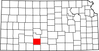 | |
| Unincorporated communities | ||
| Township | ||