Haviland, Kansas
| Haviland, Kansas | |
|---|---|
| City | |
 Location within Kiowa County and Kansas | |
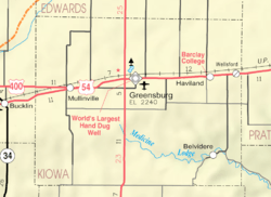 KDOT map of Kiowa County (legend) | |
| Coordinates: 37°37′0″N 99°6′20″W / 37.61667°N 99.10556°WCoordinates: 37°37′0″N 99°6′20″W / 37.61667°N 99.10556°W | |
| Country | United States |
| State | Kansas |
| County | Kiowa |
| Government | |
| • Type | Mayor-Council |
| • Mayor | Robert Ellis[1] |
| Area[2] | |
| • Total | 0.45 sq mi (1.17 km2) |
| • Land | 0.45 sq mi (1.17 km2) |
| • Water | 0 sq mi (0 km2) |
| Elevation | 2,156 ft (657 m) |
| Population (2010)[3] | |
| • Total | 701 |
| • Estimate (2016)[4] | 677 |
| • Density | 1,600/sq mi (600/km2) |
| Time zone | UTC-6 (CST) |
| • Summer (DST) | UTC-5 (CDT) |
| ZIP code | 67059 |
| Area code | 620 |
| FIPS code | 20-30825 [5] |
| GNIS ID | 0474263 [6] |
| Website | havilandks.com |
Haviland is a city in Kiowa County, Kansas, United States. As of the 2010 census, the city population was 701.[7] It is home of Barclay College and known for meteorite finds connected to the Haviland Crater and for an annual meteorite festival held in July.
History
Haviland was founded by a group of Quakers originally from Indiana and named for Laura Haviland, a leader of the Underground Railroad.[8]
The first post office in Haviland was established in June 1886.[9] Haviland was incorporated as a city in 1906.[10]
Geography
Haviland is located at 37°37′0″N 99°6′20″W / 37.61667°N 99.10556°W (37.616685, -99.105478).[11] According to the United States Census Bureau, the city has a total area of 0.45 square miles (1.17 km2), all of it land.[2]
Demographics
| Historical population | |||
|---|---|---|---|
| Census | Pop. | %± | |
| 1910 | 568 | — | |
| 1920 | 607 | 6.9% | |
| 1930 | 641 | 5.6% | |
| 1940 | 499 | −22.2% | |
| 1950 | 606 | 21.4% | |
| 1960 | 725 | 19.6% | |
| 1970 | 705 | −2.8% | |
| 1980 | 770 | 9.2% | |
| 1990 | 624 | −19.0% | |
| 2000 | 612 | −1.9% | |
| 2010 | 701 | 14.5% | |
| Est. 2016 | 677 | [4] | −3.4% |
| U.S. Decennial Census[12] | |||
2010 census
As of the census[3] of 2010, there were 701 people, 228 households, and 162 families residing in the city. The population density was 1,557.8 inhabitants per square mile (601.5/km2). There were 261 housing units at an average density of 580.0 per square mile (223.9/km2). The racial makeup of the city was 96.1% White, 1.1% African American, 1.7% Native American, 0.6% Asian, 0.1% Pacific Islander, 0.1% from other races, and 0.1% from two or more races. Hispanic or Latino of any race were 3.6% of the population.
There were 228 households of which 28.1% had children under the age of 18 living with them, 62.7% were married couples living together, 7.5% had a female householder with no husband present, 0.9% had a male householder with no wife present, and 28.9% were non-families. 25.9% of all households were made up of individuals and 12.2% had someone living alone who was 65 years of age or older. The average household size was 2.43 and the average family size was 2.93.
The median age in the city was 32.8 years. 19.4% of residents were under the age of 18; 21.9% were between the ages of 18 and 24; 20.3% were from 25 to 44; 22.5% were from 45 to 64; and 15.8% were 65 years of age or older. The gender makeup of the city was 46.9% male and 53.1% female.
2000 census
As of the census[5] of 2000, there were 612 people, 207 households, and 146 families residing in the city. The population density was 1,314.5 people per square mile (502.8/km²). There were 250 housing units at an average density of 537.0 per square mile (205.4/km²). The racial makeup of the city was 96.24% White, 1.14% African American, 0.82% Native American, 0.49% Asian, 0.98% from other races, and 0.33% from two or more races. Hispanic or Latino of any race were 3.43% of the population.
There were 207 households out of which 32.4% had children under the age of 18 living with them, 58.9% were married couples living together, 8.7% had a female householder with no husband present, and 29.0% were non-families. 27.5% of all households were made up of individuals and 8.2% had someone living alone who was 65 years of age or older. The average household size was 2.51 and the average family size was 3.08.
In the city, the population was spread out with 25.2% under the age of 18, 17.8% from 18 to 24, 19.4% from 25 to 44, 22.4% from 45 to 64, and 15.2% who were 65 years of age or older. The median age was 33 years. For every 100 females, there were 91.8 males. For every 100 females age 18 and over, there were 91.6 males.
The median income for a household in the city was $29,821, and the median income for a family was $36,250. Males had a median income of $30,179 versus $18,214 for females. The per capita income for the city was $12,075. About 6.6% of families and 11.2% of the population were below the poverty line, including 14.4% of those under age 18 and 8.3% of those age 65 or over.
Education
Primary and secondary
Haviland is served by USD 474 Haviland. The district shares Kiowa County High School with USD 422 Kiowa County Schools.[13]
Haviland High School was closed through school unification. The Haviland Dragons[14] won the Kansas State High School boys Track & Field championship in 1922.[15]
College
Barclay College, a four-year private college affiliated with the Religious Society of Friends, is located in Haviland.
See also
References
- ↑ "Governing Body". Retrieved Oct 13, 2017.
- 1 2 "US Gazetteer files 2010". United States Census Bureau. Retrieved 2012-07-06.
- 1 2 "American FactFinder". United States Census Bureau. Retrieved 2012-07-06.
- 1 2 "Population and Housing Unit Estimates". Retrieved June 9, 2017.
- 1 2 "American FactFinder". United States Census Bureau. Retrieved 2008-01-31.
- ↑ "US Board on Geographic Names". United States Geological Survey. 2007-10-25. Retrieved 2008-01-31.
- ↑ "2010 City Population and Housing Occupancy Status". U.S. Census Bureau. Retrieved July 17, 2011.
- ↑ Haviland History Accessed 6 May 2007.
- ↑ "Kansas Post Offices, 1828-1961 (archived)". Kansas Historical Society. Archived from the original on October 9, 2013. Retrieved 12 June 2014.
- ↑ Blackmar, Frank Wilson (1912). Kansas: A Cyclopedia of State History, Embracing Events, Institutions, Industries, Counties, Cities, Towns, Prominent Persons, Etc. Standard Publishing Company. p. 831.
- ↑ "US Gazetteer files: 2010, 2000, and 1990". United States Census Bureau. 2011-02-12. Retrieved 2011-04-23.
- ↑ United States Census Bureau. "Census of Population and Housing". Retrieved September 12, 2014.
- ↑ "USD 474 - Haviland". USD 474. Retrieved 5 January 2017.
- ↑ "Bison Buffaloes Stomp Haviland", Great Bend Tribune, 15 January 1969, p.6.
- ↑ "Track & Field". KSHSAA. Retrieved 6 January 2017.
External links
| Wikimedia Commons has media related to Haviland, Kansas. |
- City
- Schools
- USD 474, local school district
- Places of Interest
- Maps
- Haviland City Map, KDOT
Municipalities and communities of Kiowa County, Kansas, United States | ||
|---|---|---|
| Cities | 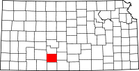 | |
| Unincorporated communities | ||
| Township | ||