Kingston Norman Rogers Airport
| Kingston Airport | |||||||||||||||||||
|---|---|---|---|---|---|---|---|---|---|---|---|---|---|---|---|---|---|---|---|
 | |||||||||||||||||||
| Summary | |||||||||||||||||||
| Airport type | Public | ||||||||||||||||||
| Operator | City of Kingston | ||||||||||||||||||
| Location | Kingston, Ontario | ||||||||||||||||||
| Time zone | EST (UTC−05:00) | ||||||||||||||||||
| • Summer (DST) | EDT (UTC−04:00) | ||||||||||||||||||
| Elevation AMSL | 303 ft / 92 m | ||||||||||||||||||
| Coordinates | 44°13′33″N 076°35′48″W / 44.22583°N 76.59667°WCoordinates: 44°13′33″N 076°35′48″W / 44.22583°N 76.59667°W | ||||||||||||||||||
| Website | www.cityofkingston.ca | ||||||||||||||||||
| Map | |||||||||||||||||||
 CYGK Location in Ontario | |||||||||||||||||||
| Runways | |||||||||||||||||||
| |||||||||||||||||||
| Statistics (2010) | |||||||||||||||||||
| |||||||||||||||||||
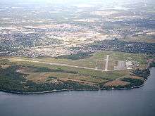
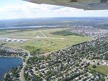
Kingston Airport (IATA: YGK, ICAO: CYGK), also known as Norman Rogers Airport, is an airport located 4.3 nautical miles (8.0 km; 4.9 mi) west of the core of Kingston, Ontario, Canada.
The airport is named after former MP Norman McLeod Rogers (Kingston City 1935–1940), Minister of Labour and then National Defence in Prime Minister William Lyon Mackenzie King's cabinet. Rogers died in a plane crash on June 10, 1940 while flying from Ottawa to Toronto for a speaking engagement.
History


Before 1940, Kingston was served only by the Kingston Airfield, a grass strip just north of the city's downtown, which closed in 1942. In 1940, during the Second World War, an airfield was built to the west of Kingston to serve as a training station for the Royal Air Force's No. 31 Service Flying Training School (SFTS). The school provided advanced flight training in Battle and Harvard aircraft. In 1942 the school became part of the British Commonwealth Air Training Plan (BCATP). The BCATP's No. 14 Service Flying Training School moved to Kingston in 1944 and merged with the RAF school. No. 14 SFTS used Harvards, Yales and Ansons. A decommissioned yellow Harvard aircraft now stands on a pedestal near the airport entrance to commemorate the airport's wartime role. The airport was transferred to city control in 1972.
The airport's runway outline displays the classic BCATP triangle pattern. The airport was built with six 2,500 ft (760 m) runways; however, this was reduced to three, as they were all parallel runways. One can still see where some parts of the parallel runways were from the air. Later, runway 01/19 was extended northwards to a length of 5,000 ft (1,500 m) to handle larger aircraft, and it is planned to be extended to 6,000 ft (1,800 m) (the prevailing wind is from the south off Lake Ontario). Runway 07/25 was extended northeastwards to a length of nearly 4,000 ft (1,200 m), with no plans to extend it, due to the requirements for certified airports on runways over a certain length. The remaining runway, 12/30, was decommissioned in 2003 and converted to a taxiway.
Airlines and destinations
| Airlines | Destinations |
|---|---|
| Air Canada Express | Toronto–Pearson |
Air cargo carriers and destinations
| Airlines | Destinations |
|---|---|
| SkyLink Express | Hamilton |
Frequencies
Kingston Airport services three frequencies: ATIS (135.550 MHz) and radio (122.500 MHz). There is also guidance for private aircraft needing fuel or parking on Kingston Flying Club Advisory (122.800MHz)
Operations
Kingston is a mandatory frequency airport with an operating flight service station. The airport also supports a large amount of general aviation traffic, including flight training and general recreational flying. As one of the only public airports to offer an ILS approach along the corridor between Montreal and Toronto (along with Ottawa), the Kingston airport is an important alternate during poor weather conditions.
There are two Flight Training Units located on the field. Kingston Flying Club, a flight school and charter operation is located in hangar 5 and Fly Kingston/Fly Canadian is located in hangaar 4.
The airport is classified as an airport of entry by Nav Canada and is staffed by the Canada Border Services Agency. CBSA officers at this airport can handle aircraft with no more than 30 passengers.[1]
See also
References
- 1 2 Canada Flight Supplement. Effective 0901Z 19 July 2018 to 0901Z 13 September 2018.
- ↑ Synoptic/Metstat Station Information Archived 2012-07-07 at Archive.is
- ↑ Total aircraft movements by class of operation — NAV CANADA flight service stations
External links
- Official website
- Page about this airport on COPA's Places to Fly airport directory
- Past three hours METARs, SPECI and current TAFs for Kingston Airport from Nav Canada as available.
| By name | |
|---|---|
| By location indicator | |
| By province/territory | |
| By area | |
| National Airports System | |
| Related | |
| |