Khiam
| Khiam الخيام; | |
|---|---|
| City | |
 Khiam | |
 Khiam Location within Lebanon | |
| Coordinates: 33°19′37.80″N 35°36′39.96″E / 33.3271667°N 35.6111000°ECoordinates: 33°19′37.80″N 35°36′39.96″E / 33.3271667°N 35.6111000°E | |
| Grid position | 137/154L |
| Country |
|
| Governorate | Nabatieh Governorate |
| District | Marjeyoun District |
| Elevation | 695 m (2,280 ft) |
| Time zone | UTC+2 (EET) |
| • Summer (DST) | UTC+3 (EEST) |
| Dialing code | +961 |
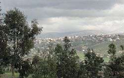
Khiam (Arabic الخيام; sometimes spelled Khiyam) is a large town in the Nabatieh Governorate of Southern Lebanon.
Location
Khiam is situated approximately 130 kilometres (81 mi) south from the capital city of Beirut and 35 kilometres (22 mi) south-east from the city of Nabatieh. The border with Israel is 5 kilometres (3 mi) to the south. Khiam lies at a height of 800 metres (2,625 ft) above sea level.
Origin of name
E. H. Palmer wrote that the name means "The tents".[1]
History
In 1596, it was named as a village, Hiyam, in the Ottoman nahiya (subdistrict) of Tibnin under the liwa' (district) of Safad, with a population of 111 households and 7 bachelors, all Muslim. The villagers paid a tax on agricultural products, such as wheat, barley, olive trees, vineyards, goats and beehives, in addition to "occasional revenues"; a total of 6,914 akçe.[2][3]
In 1875 Victor Guérin visited: "El Khiam contains two quarters: the one on the south, with a population of 700 Metawileh, and the other on the north, with 600 Christians, divided into Maronites, Greek-Orthodox, and Greek-Catholics, with some Protestants, who have founded a chapel and a school."[4]
In 1881, the Palestine Exploration Fund's Survey of Western Palestine (SWP) described it as: "A village, north-east of the Merj Ayun, built of stone, containing about 300 Christians and 200 Druzes. It contains a white round Moslem holy place and a modern church. It is situated on a low ridge, surrounded by figs, olives, and arable. The water supply is from three rock-cut cisterns, one birket, and the good spring of 'Ain ed Derdarah."[5]
Modern era
During the 1990s Khiam became known for the Khiam Detention Center, operated by the South Lebanon Army during the Israeli occupation southern of Lebanon. Some Lebanese civilians were exposed to torture in this camp and faced indefinite detention once arrested. The prison was captured by Hezbollah during the Battle of Khiam in 2000, shortly before Israeli withdrawal from the South Lebanon security belt.
The town saw a major confrontation between the Israeli Army and Hezbollah fighters in the 2006 Lebanon War during which a United Nations post was bombed by the Israeli Army killing four United Nations Military Observers.[6]
References
- ↑ Palmer, 1881, p. 26
- ↑ Hütteroth and Abdulfattah, 1977, p. 181
- ↑ Note that Rhode, 1979, p. 6 writes that the register that Hütteroth and Abdulfattah studied was not from 1595/6, but from 1548/9
- ↑ Guerin, 1880, p. 279; as given in Conder and Kitchener, 1881, SWP I, p. 88
- ↑ Conder and Kitchener, 1881, SWP I, p. 88
- ↑ HRW, 2007, pp. 114-116
Bibliography
- Conder, C.R.; Kitchener, H.H. (1881). The Survey of Western Palestine: Memoirs of the Topography, Orography, Hydrography, and Archaeology. 1. London: Committee of the Palestine Exploration Fund.
- Guérin, V. (1880). Description Géographique Historique et Archéologique de la Palestine (in French). 3: Galilee, pt. 2. Paris: L'Imprimerie Nationale.
- HRW (2007). Why They Died: Civilian Casualties in Lebanon During the 2006 War. Human Rights Watch.
- Hütteroth, Wolf-Dieter; Abdulfattah, Kamal (1977). Historical Geography of Palestine, Transjordan and Southern Syria in the Late 16th Century. Erlanger Geographische Arbeiten, Sonderband 5. Erlangen, Germany: Vorstand der Fränkischen Geographischen Gesellschaft. ISBN 3-920405-41-2.
- Palmer, E.H. (1881). The Survey of Western Palestine: Arabic and English Name Lists Collected During the Survey by Lieutenants Conder and Kitchener, R. E. Transliterated and Explained by E.H. Palmer. Committee of the Palestine Exploration Fund.
- Rhode, H. (1979). Administration and Population of the Sancak of Safed in the Sixteenth Century. Columbia University.
External links
- Survey of Western Palestine, Map 2: IAA, Wikimedia commons
- Khiyam, Localiban
- Khiam Official website
- Khiam center
- In focus: Al-Khiyam, BBC profile
| Capital | 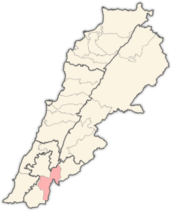 | |
|---|---|---|
| Towns and villages | ||
| Other | ||