Keurboomstrand
| Keurboomstrand | |
|---|---|
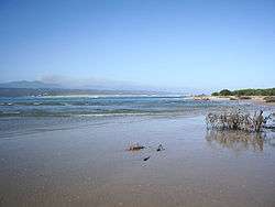 The Keurbooms rivermouth | |
 Keurboomstrand  Keurboomstrand Keurboomstrand (South Africa)  Keurboomstrand Keurboomstrand (Africa) | |
| Coordinates: 34°00′S 23°27′E / 34.000°S 23.450°ECoordinates: 34°00′S 23°27′E / 34.000°S 23.450°E | |
| Country | South Africa |
| Province | Western Cape |
| District | Garden Route |
| Municipality | Bitou |
| Area[1] | |
| • Total | 9.75 km2 (3.76 sq mi) |
| Population (2011)[1] | |
| • Total | 475 |
| • Density | 49/km2 (130/sq mi) |
| Racial makeup (2011)[1] | |
| • Black African | 2.3% |
| • Coloured | 13.5% |
| • White | 82.9% |
| • Other | 1.3% |
| First languages (2011)[1] | |
| • Afrikaans | 49.9% |
| • English | 48.6% |
| • Other | 1.5% |
| Time zone | UTC+2 (SAST) |
Keurboomstrand is a resort town near Plettenberg Bay on the Western Cape of South Africa. It takes its name from the indigenous keurboom tree which grows in the region. The Keurbooms River runs nearby.
History
The Matjes River Rock Shelter nearby contains artefacts from the Bushmen dating back to the Neolithic period 11,000 years ago and is a National Monument.[2] The shell middens at the site is one of the largest in the world being 10 metres high, 15 metres wide and 30 metres long, but have been degraded
Portuguese explorers from the Silo Goncalo were ship-wrecked nearby in 1630 for eight months which was the first European settlement in South Africa.
See also
Notes
- 1 2 3 4 "Main Place Keurboomstrand". Census 2011.
- ↑ http://www.sahra.org.za/sites/920520021
Municipalities and communities of Garden Route District Municipality, Western Cape | ||
|---|---|---|
District seat: George | ||
| Bitou | .svg.png) | |
| George | ||
| Hessequa | ||
| Kannaland | ||
| Knysna | ||
| Mossel Bay | ||
| Oudtshoorn | ||
This article is issued from
Wikipedia.
The text is licensed under Creative Commons - Attribution - Sharealike.
Additional terms may apply for the media files.