De Hoop, Western Cape
| De Hoop | |
|---|---|
 De Hoop, Oudtshoorn | |
 De Hoop  De Hoop De Hoop (South Africa)  De Hoop De Hoop (Africa) | |
| Coordinates: 33°36′25″S 22°02′42″E / 33.607°S 22.045°ECoordinates: 33°36′25″S 22°02′42″E / 33.607°S 22.045°E | |
| Country | South Africa |
| Province | Western Cape |
| District | Eden |
| Municipality | Oudtshoorn |
| Area[1] | |
| • Total | 0.57 km2 (0.22 sq mi) |
| Population (2011)[1] | |
| • Total | 151 |
| • Density | 260/km2 (690/sq mi) |
| Racial makeup (2011)[1] | |
| • Coloured | 71.3% |
| • White | 28.7% |
| First languages (2011)[1] | |
| • Afrikaans | 99.3% |
| • Other | 0.7% |
| Time zone | UTC+2 (SAST) |
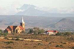
De Hoop is a town in Oudtshoorn Local Municipality in the Western Cape province of South Africa.
Village of the Dutch Reformed Church 16 km west of Oudtshoorn. It was laid out in July 1908 and so named with reference to Rom. 5:5, 'hope maketh not ashamed'; the definite article is often used in Dutch and Afrikaans in conjunction with abstract nouns.[2]
References
- 1 2 3 4 "Main Place De Hoop". Census 2011.
- ↑ Raper, Peter E. (1987). Dictionary of Southern African Place Names. Internet Archive. p. 133. Retrieved 28 August 2013.
Municipalities and communities of Garden Route District Municipality, Western Cape | ||
|---|---|---|
District seat: George | ||
| Bitou | .svg.png) | |
| George | ||
| Hessequa | ||
| Kannaland | ||
| Knysna | ||
| Mossel Bay | ||
| Oudtshoorn | ||
This article is issued from
Wikipedia.
The text is licensed under Creative Commons - Attribution - Sharealike.
Additional terms may apply for the media files.