Brenton-on-Sea
| Brenton-on-Sea | |
|---|---|
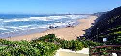 View of the beach | |
 Brenton-on-Sea  Brenton-on-Sea Brenton-on-Sea (South Africa)  Brenton-on-Sea Brenton-on-Sea (Africa) | |
| Coordinates: 34°04′S 23°01′E / 34.067°S 23.017°ECoordinates: 34°04′S 23°01′E / 34.067°S 23.017°E | |
| Country | South Africa |
| Province | Western Cape |
| District | Garden Route |
| Municipality | Knysna |
| Area[1] | |
| • Total | 1.76 km2 (0.68 sq mi) |
| Population (2011)[1] | |
| • Total | 294 |
| • Density | 170/km2 (430/sq mi) |
| Racial makeup (2011)[1] | |
| • Black African | 5.1% |
| • Coloured | 1.7% |
| • White | 91.2% |
| • Other | 2.0% |
| First languages (2011)[1] | |
| • Afrikaans | 50.2% |
| • English | 44.7% |
| • Other | 5.1% |
| Time zone | UTC+2 (SAST) |
Brenton-on-Sea is a settlement and seaside resort town 15km west of Knysna in Eden District Municipality in the Western Cape province of South Africa.
Named after Sir Jahleel Brenton, who declared Knysna a harbour in 1818, the area is home to the endangered Brenton blue butterfly.
It is part of the Garden Route and a popular spot for seaside vacations and holidays.
The endangered Brenton Blue butterfly is responsible for large sects of land in the Brenton area remaining undeveloped. The last breeding colonies of the tiny endemic butterfly are found here and in 2003, the land was proclaimed a Special Nature Reserve to try and save the species. [2]
References
Municipalities and communities of Garden Route District Municipality, Western Cape | ||
|---|---|---|
District seat: George | ||
| Bitou | .svg.png) | |
| George | ||
| Hessequa | ||
| Kannaland | ||
| Knysna | ||
| Mossel Bay | ||
| Oudtshoorn | ||
This article is issued from
Wikipedia.
The text is licensed under Creative Commons - Attribution - Sharealike.
Additional terms may apply for the media files.