Herolds Bay
| Herolds Bay Heroldsbaai | |
|---|---|
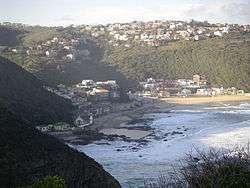 View from a lookout point south west of the town. | |
 Herolds Bay  Herolds Bay Herolds Bay (South Africa)  Herolds Bay Herolds Bay (Africa) | |
| Coordinates: 34°03′02″S 22°23′51″E / 34.05056°S 22.39750°ECoordinates: 34°03′02″S 22°23′51″E / 34.05056°S 22.39750°E | |
| Country | South Africa |
| Province | Western Cape |
| District | Eden |
| Municipality | George |
| Area[1] | |
| • Total | 1.03 km2 (0.40 sq mi) |
| Population (2011)[1] | |
| • Total | 704 |
| • Density | 680/km2 (1,800/sq mi) |
| Racial makeup (2011)[1] | |
| • Black African | 2.7% |
| • Coloured | 33.8% |
| • Indian/Asian | 0.1% |
| • White | 61.6% |
| • Other | 1.7% |
| First languages (2011)[1] | |
| • Afrikaans | 89.8% |
| • English | 9.6% |
| • Other | 0.6% |
| Time zone | UTC+2 (SAST) |
Herolds Bay is a settlement in Eden District Municipality in the Western Cape province of South Africa.
Holiday resort west of Malgas River mouth, some 24km south-west of George and east of Guano Bay. Named after the first Dutch Reformed minister of George, Tobias Johannes Herold (1812-1823).[2]
References
- 1 2 3 4 "Main Place Herolds Bay". Census 2011.
- ↑ "Dictionary of Southern African Place Names (Public Domain)". Human Science Research Council. p. 208.
Municipalities and communities of Garden Route District Municipality, Western Cape | ||
|---|---|---|
District seat: George | ||
| Bitou | .svg.png) | |
| George | ||
| Hessequa | ||
| Kannaland | ||
| Knysna | ||
| Mossel Bay | ||
| Oudtshoorn | ||
This article is issued from
Wikipedia.
The text is licensed under Creative Commons - Attribution - Sharealike.
Additional terms may apply for the media files.