Kents Hill, Monkston and Brinklow
| Monkston, Kents Hill and Brinklow | |
|---|---|
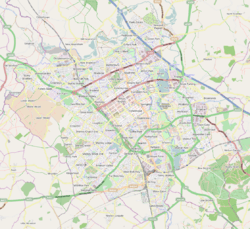 Monkston, Kents Hill and Brinklow Mapping © OpenStreetMap 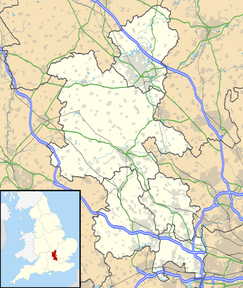 Monkston, Kents Hill and Brinklow Monkston, Kents Hill and Brinklow shown within Buckinghamshire | |
| Population | 8,344 (2011 Census)[1] |
| OS grid reference | SP895371 |
| Civil parish |
|
| Unitary authority | |
| Ceremonial county | |
| Region | |
| Country | England |
| Sovereign state | United Kingdom |
| Post town | MILTON KEYNES |
| Postcode district | MK9, MK10 |
| Dialling code | 01908 |
| Police | Thames Valley |
| Fire | Buckinghamshire |
| Ambulance | South Central |
| EU Parliament | South East England |
| UK Parliament | |
Monkston, Kents Hill and Brinklow is a civil parish that covers the Kents Hill, Brinklow, Monkston, Monkston Park and Kingston districts of Milton Keynes.[2] As the first tier of Local Government, the Parish Council is responsible for the people, living and working in this area of Milton Keynes.
The Parish was formed in 2001 as part of a general parishing of the Borough of Milton Keynes. It is bounded by Chaffron Way, the Broughton Brook, Newport Road, Groveway, Brickhill Street, Standing Way, and the River Ouzel.
Districts of the parish
Kents Hill
The west side of this district contains part of the Open University campus (the buildings originally belonged to De Montfort University), the Accenture training centre and the Hilton Milton Keynes.[3] The rest of the district is residential, much of it overlooking a large recreational area. There is a local shop, a church, three parks and three 11-a-side football pitches in the district. There is also a school which consists of a nursery and a first school and a new all-through primary and secondary school opening in September 2018.
Monkston and Monkston Park
This is primarily a residential district based around a large circular recreational area and a combined school. Monkston Park is near to the River Ouzel and has its own small local centre and a nearby 'village green'. Both areas although sharing a similar name are actually separated by the V10 Brickhill Street.
Pre-history
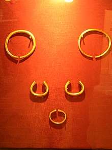
The area that was to become Milton Keynes was relatively rich: possibly the largest (by weight) hoard of Bronze Age jewellery ever found in Britain ("the Milton Keynes Hoard") was discovered in Monkston and consists of two late Bronze Age gold torcs and three gold bracelets.[4][5]
Kingston
The Kingston district is primarily a manufacturing and distribution industries one [due to its proximity to Junctions 13 and 14 of the M1]. At its centre is a large retail complex, dominated by a Tesco hypermarket: this complex serves the eastern and south-eastern suburbs of Milton Keynes.
Brinklow
This is a relatively small warehousing and industrial district. It is dominated by the large Waitrose distribution centre.
Electoral ward (Borough)
The Parish falls within the Monkston Ward of the Borough of Milton Keynes. As a result, the Parish has three Borough Councillors representing it: Andrew Buckley (Conservatives), Jenni Ferrans (Liberal Democrats) and Vanessa McPake (Liberal Democrats).[6]
References
- ↑ Neighbourhood Statistics 2011 census, Accessed 4 February 2013
- ↑ "Parish Map of Milton Keynes" (PDF). Milton Keynes Council. Archived from the original (PDF) on 16 September 2012. Retrieved 26 April 2012.
- ↑ Hilton Milton Keynes location
- ↑ British Museum: the Milton Keynes Hoard (now in collection of the British Museum, replicas are on display in the Milton Keynes Museum)
- ↑ Needham, S (2002). "Milton Keynes, Buckinghamshire: Bronze Age gold hoard of two torcs and three bracelets in a pot" (PDF). Treasure Annual Report 2000. Department of Culture, Media and Sport. pp. 13–15. Archived from the original (PDF) on 1 March 2012. Retrieved 26 July 2010.
- ↑ Interactive mapping – Milton Keynes Council
External links
- Housing in Kents Hill with photographs on MKweb
- Housing in Monkston – MKweb