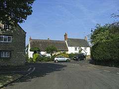
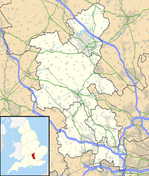
Sherington
| Sherington | |
|---|---|
 Sherington | |
 Sherington Sherington shown within Buckinghamshire | |
| Population | 954 (2011 Census)[1] |
| OS grid reference | SP888463 |
| Civil parish |
|
| Unitary authority | |
| Ceremonial county | |
| Region | |
| Country | England |
| Sovereign state | United Kingdom |
| Post town | NEWPORT PAGNELL |
| Postcode district | MK16 |
| Dialling code | 01908 |
| Police | Thames Valley |
| Fire | Buckinghamshire |
| Ambulance | South Central |
| EU Parliament | South East England |
| UK Parliament | |
Sherington is a village and civil parish in the Borough of Milton Keynes and ceremonial county of Buckinghamshire, England.[2] It is located just north east of Newport Pagnell, by the A509.
Toponymy
The village name is an Old English language word, and means 'Scira's estate'. In the Domesday Book of 1086 the village was recorded as Serintone. The parish church is dedicated to Saint Laud.
Twin village
Demography
| St Peters compared | |||
|---|---|---|---|
| 2001 UK Census | Sherington ward | Milton Keynes UA | England |
| Population | 3,953 | 207,057 | 49,138,831 |
| Foreign born | 4.9% | 9.9% | 9.2% |
| White | 98.3% | 90.7% | 90.9% |
| Asian | 0.7% | 4.5% | 4.6% |
| Black | 0.2% | 2.4% | 2.3% |
| Christian | 76% | 65.5% | 71.7% |
| Muslim | 0.2% | 2.3% | 3.1% |
| Hindu | 0.1% | 1.3% | 1.1% |
| No religion | 15.8% | 21.6% | 14.6% |
| Unemployed | 1.9% | 3% | 3.3% |
| Retired | 14.3% | 9% | 13.5% |
At the 2001 UK census, the Sherington electoral ward had a population of 3,953. The ethnicity was 98.3% white, 0.7% mixed race, 0.7% Asian, 0.2% black and 0.1% other. The place of birth of residents was 95.1% United Kingdom, 0.5% Republic of Ireland, 1.7% other Western European countries, and 2.7% elsewhere. Religion was recorded as 76% Christian, 0.1% Buddhist, 0.1% Hindu, 0.1% Sikh, 0.3% Jewish, and 0.2% Muslim. 15.8% were recorded as having no religion, 0.1% had an alternative religion and 7.2% did not state their religion.[4]
The economic activity of residents aged 16–74 was 41.6% in full-time employment, 11.5% in part-time employment, 15.1% self-employed, 1.9% unemployed, 1.6% students with jobs, 3% students without jobs, 14.3% retired, 6.9% looking after home or family, 2.2% permanently sick or disabled and 1.8% economically inactive for other reasons. The industry of employment of residents was 17% retail, 12.1% manufacturing, 5.5% construction, 20.2% real estate, 6.9% health and social work, 10.5% education, 6.9% transport and communications, 3.4% public administration, 4.2% hotels and restaurants, 3.9% finance, 4.1% agriculture and 5.3% other. Compared with national figures, the ward had a relatively high proportion of workers in agriculture, education and real estate. There were a relatively low proportion in public administration, and health and social work. Of the ward's residents aged 16–74, 28.3% had a higher education qualification or the equivalent, compared with 19.9% nationwide.[4]
Current controversy
As happened earlier[5] at Bow Brickhill to the south of Milton Keynes, a US speculator has bought agricultural land at Abbey View near Sherington Bridge, divided it into domestic sized plots and is attempting[6] to sell these off as suitable for future self-build development, although the land is zoned agricultural and may be expected to remain so for the foreseeable future - the Council's 25-year plan (to 2030) projects that it will remain so.
References
- ↑ Neighbourhood Statistics 2011 Census, Accessed 4 February 2013
- ↑ Parishes in Milton Keynes Archived 2009-06-08 at the Wayback Machine. - Milton Keynes Council.
- ↑ http://www.sherington.org.uk/sameon.htm
- 1 2 "Neighbourhood Statistics". Statistics.gov.uk. Retrieved 2008-04-20.
- ↑ The new game of patience (The Guardian)
- ↑ Land sales lead to a panic Milton Keynes Citizen / Milton Keynes Today
External links
| Wikimedia Commons has media related to Sherington. |