Kenting National Park
| Kenting National Park | |
|---|---|
|
IUCN category II (national park) | |
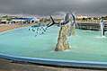
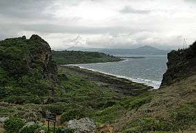 Cape Maobitou in Kenting National Park | |
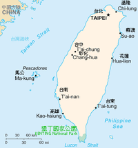 Location of Kenting National Park in Taiwan | |
| Location | Taiwan |
| Nearest city | Hengchun |
| Coordinates | 21°58′48″N 120°47′49″E / 21.98°N 120.797°ECoordinates: 21°58′48″N 120°47′49″E / 21.98°N 120.797°E |
| Area | 333 km2 (129 sq mi) |
| Established | 1 January 1984 |
| Visitors | 8,376,708 (in 2014) |
| Governing body | Kenting National Park Administration Office |
|
www | |
| Kenting National Park | |||||||||||||
| Traditional Chinese | 墾丁國家公園 | ||||||||||||
|---|---|---|---|---|---|---|---|---|---|---|---|---|---|
| Simplified Chinese | 垦丁国家公园 | ||||||||||||
| |||||||||||||
Kenting National Park (Chinese: 墾丁國家公園; pinyin: Kěndīng Gúojiā Gōngyuán), commonly known as Kenting (Chinese: 墾丁; pinyin: Kěndīng), is a national park located on the Hengchun Peninsula of Pingtung County, Taiwan, covering Hengchun, Checheng, and Manzhou Townships. Established on January 1, 1984, it is Taiwan's oldest and southernmost national park, covering the southernmost area of the Taiwan island along Bashi Channel. Administered by the Executive Yuan's Ministry of the Interior, this national park is well known for its tropical climate and sunshine, scenic mountain and beach, the Spring Scream rock-band festival held in every March,[1] and has long been one of the most popular tourist destinations in Taiwan with 5.84 million visitors in 2016.[2]
Etymology
Kenting (墾丁, Kun-ting in Taiwanese) means pathfinders or pioneers.
Geography
The park covers about 181 square kilometres (70 sq mi) of land, 152 square kilometres (59 sq mi) of sea, weighing in at 333 square kilometres (129 sq mi) combined. Nan Wan and Banana Bay (香蕉灣) is surrounded by the Pacific Ocean, the Taiwan Strait, and the Luzon Strait. The park is 90 kilometres (56 mi) away from Kaohsiung, 140 kilometres (87 mi) away from Tainan.
The landscape boasted by Kenting National Park is divided into two parts by the long and narrow Hengchun Longitudinal Valley Plain that extends from north to south. With coral sea cliffs teemed with fringing reefs along the west coast, the park features a large number of mountains in the north, and coral tablelands and foothills in the south. The plain, which is formed by fault valleys, has a vast lake called Longluan Lake, together with rising coral tablelands and limestone caves to the east. The east side of the coral tablelands features unique sand rivers and sand waterfalls formed by the combined effects of winds and rivers, as well as coral cliffs, sunken caves and stalactites.
Biodiversity
The park hosts rich terrestrial biodiversity of fauna and flora including 15 species of mammals, 310 species of birds, 59 species of reptiles and amphibians, 21 species of freshwater fish, 216 species of butterflies, and various insects.[3]
Eluanbi Park or Oluanpi Park (鹅鑾鼻公園) is located at Cape Eluanbi.[4] Nature reserves such as the Longkeng Ecological Protection Area (龍坑生態保護區)[5] protecting coral reefs and virgin forest of Banana Bay and Hengchun Peninsula.[6] 26 species of land crabs inhabit in the area and which is the highest diversity of terrestrial crabs in single areas in the world.[7]
Ocean current which flows off the park provides rich diversities of marine ecosystems including sea birds, sea turtles including critically endangered hawksbill turtles,[8] sharks such as bull sharks[9] and whale sharks,[10][11] and smaller to medium-sized cetaceans.[12][13][14][15] The area was once a major wintering ground for sperm and baleen whales[16] especially humpback whales that migrated into Nan Wan and Banana Bay.[17] Japanese whaling during Japanese colonial days,[18][19][20] led to severe depletions or disappearances of whales in consequence. Today, no or very few whales may constantly migrate along Hengchun Peninsula and into the park's waters.[21][22][23] Dugongs, thought to be either fully or functionally extinct in Taiwan, were reported in 1950s and 60s, and these were some of the last report of the species in Taiwanese waters.[24]
Climate
Kenting is known for its tropical climate with warm to hot weather year-round. Along with the rest of Pingtung, the climate is geographically classified as a tropical monsoon climate.
| Climate data for Kenting National Park | |||||||||||||
|---|---|---|---|---|---|---|---|---|---|---|---|---|---|
| Month | Jan | Feb | Mar | Apr | May | Jun | Jul | Aug | Sep | Oct | Nov | Dec | Year |
| Average high °C (°F) | 25.5 (77.9) |
26.1 (79) |
27.5 (81.5) |
29.5 (85.1) |
31.0 (87.8) |
31.5 (88.7) |
32.0 (89.6) |
31.7 (89.1) |
31.1 (88) |
29.8 (85.6) |
27.6 (81.7) |
26.8 (80.2) |
29.2 (84.5) |
| Daily mean °C (°F) | 21.5 (70.7) |
22.0 (71.6) |
23.8 (74.8) |
25.8 (78.4) |
27.5 (81.5) |
28.4 (83.1) |
28.7 (83.7) |
28.4 (83.1) |
27.8 (82) |
26.7 (80.1) |
24.8 (76.6) |
22.3 (72.1) |
25.6 (78.1) |
| Average low °C (°F) | 18.2 (64.8) |
18.8 (65.8) |
20.2 (68.4) |
22.3 (72.1) |
24.1 (75.4) |
25.3 (77.5) |
25.6 (78.1) |
25.3 (77.5) |
24.7 (76.5) |
23.9 (75) |
22.0 (71.6) |
19.3 (66.7) |
22.5 (72.5) |
| Average rainfall mm (inches) | 25.7 (1.012) |
27.7 (1.091) |
19.9 (0.783) |
43.5 (1.713) |
163.9 (6.453) |
371.3 (14.618) |
396.3 (15.602) |
475.2 (18.709) |
288.3 (11.35) |
141.8 (5.583) |
43.2 (1.701) |
20.6 (0.811) |
2,017.4 (79.425) |
| Average rainy days (≥ 0.1 mm) | 8.0 | 6.8 | 4.8 | 6.3 | 11.1 | 16.9 | 16.4 | 18.9 | 15.9 | 10.8 | 7.1 | 6.1 | 129.1 |
| Average relative humidity (%) | 72.6 | 73.7 | 74.4 | 75.4 | 78.5 | 83.6 | 83.3 | 84.0 | 79.7 | 74.0 | 70.8 | 70.7 | 76.7 |
| Mean monthly sunshine hours | 168.0 | 165.1 | 199.7 | 192.6 | 193.9 | 183.6 | 221.0 | 195.5 | 177.2 | 198.1 | 177.7 | 161.4 | 2,233.8 |
| Source: Central Weather Bureau[25] | |||||||||||||
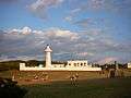
Lighthouse
Eluanbi Lighthouse was completed in 1883, following requests from the American and Japanese governments to the Chinese government after several shipwrecks occurred in the 1860s (including the Rover incident). Chinese troops had to be sent to protect the lighthouse during construction from attacks by local tribesmen, and the lighthouse was surrounded by a fort with cannons and a ditch for protection.[26] It is one of the rare examples in the world of a fortified lighthouse. The lighthouse itself is 21.4 metres (70 ft) high and its light is 56.4 metres (185 ft) above the tidal high water. The light flashes every 10 seconds and its range is 27.2 nautical miles (50.4 km).
Transportation
- Bus: Frequent buses link this park with Kaohsiung International Airport, Taiwan Railway Administration's Kaohsiung Station and Taiwan High Speed Rail's Zuoying Station. One-way ride takes around 2 hours and 30 minutes.
- Air: This park is served by the domestic Hengchun Airport although flights are rare and are subject to cancellation due to the strong Katabatic wind which is frequent in the Hengchun Peninsula.
In popular culture
- Spring Scream: A well-known international rock-band festival held inside this park since 1995
- Most parts of the movie Cape No. 7 were filmed inside this park, and nearby Hengchun
Gallery
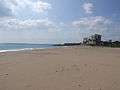 Beach view from Kenting beach
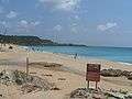 Another beach in Kenting, Baishawan, White Sand beach
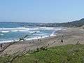 Jialeshui beach in Kenting, the surfer beach
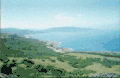 East Coast in Kenting National Park
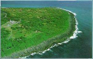
See also
References
- ↑ Spring Scream Official Website
- ↑ Matthew Strong (2017-04-08). "Kenting is Taiwan's most popular national park". Taiwan News. Retrieved 2017-04-08.
- ↑ 3.3 Wildlife-Ecology-Kenting National Park Archived 2016-06-25 at the Wayback Machine.
- ↑ http://focustaiwan.tw/news/asoc/201512250024.aspx
- ↑ http://usl.uukt.tw/
- ↑ http://uukt.com.tw/_tw/member/01_detail.php?kd=307
- ↑ http://ourisland.pts.org.tw/content/%E6%A4%B0%E5%AD%90%E8%9F%B9%E7%9A%84party#sthash.la326cmN.dpbs
- ↑ Kenting National Park HQ releases a green turtle into the wild Archived 2016-06-25 at the Wayback Machine.
- ↑ http://news.ltn.com.tw/news/focus/paper/409848
- ↑ 怪不得海生館
- ↑ 2度擱淺 粗魯野放 海生館「害死鯨鯊」
- ↑ 墾丁國家公園海域哺乳類動物相調查
- ↑ 墾丁國家公園鄰近海域鯨豚類生物調查研究
- ↑ 海域哺乳類動物相調查 - 墾丁國家公園
- ↑ 2017, 墾丁後壁湖 海豚跳躍引尖叫聲
- ↑ 墾丁國家公園--生物資料庫查詢
- ↑ Acebes V.M.J., 2009, A history of Whaling in Philippines, Historical Perspectives of Fisheries Exploitation in the Indo-Pacific, Asia Research Centre, Murdoch University
- ↑ http://www.appledaily.com.tw/realtimenews/article/new/20141211/521242/
- ↑ http://e-info.org.tw/node/109767
- ↑ http://whaleanddolphin.lym.gov.tw/know02.html
- ↑ 鯨魚噴水奇景 墾丁民眾驚嘆
- ↑ 〈南部〉恆春鯨魚噴水! 萬里桐居民驚喜
- ↑ 2017, 稀客大翅鯨現身墾丁外海 遺憾是鯨屍
- ↑ Dugong - Status Report and Action Plans for Countries and Territories
- ↑ "Climate". Central Weather Bureau.
- ↑ Chanson, H. (2007). Coastal Observations: Erluanbi, Southern Taiwan. Shore & Beach, Vol. 75, No. 2, pp. 36-39 (ISSN 0037-4237).
External links
| Wikimedia Commons has media related to Kenting National Park. |
| Wikivoyage has a travel guide for Kenting National Park. |
- Official website (in English)
- UU Kenting (in Chinese)
- Kenting National Park on Taiwan Mag (in French)
- Kenting Weekend CondeNast Traveler Mag (in English)
- Coastal Observations: Erluanbi, Southern Taiwan in Shore & Beach, Vol. 75, No. 2, pp. 36–39 (ISSN 0037-4237)
- Mount Dejian, Kenting, Pintung County, South Coast of Taiwan, Coastal Photograph by Hubert Chanson in Journal of Coastal Research, Vol. 25, No. 3, May, p. 672 (ISSN 0749-0208)