Keinawa Expressway
| |
|---|---|
|
京奈和自動車道 (Keinawa Jidōsha-dō) | |
| Route information | |
| Length | 104.9 km (65.2 mi) |
| Major junctions | |
| North end |
Jōyō Interchange |
| South end |
Wakayama Junction |
| Highway system | |
|
National highways of Japan Expressways of Japan | |
The Keinawa Expressway (京奈和自動車道 Keinawa Jidōsha-dō) is an expressway in the Kinki region of Japan that connects Kyoto Prefecture to Wakayama Prefecture and its capital city Wakayama. It is numbered "E24" as outlined in the "2016 Proposal for Realization of Expressway Numbering."[1]
Route description
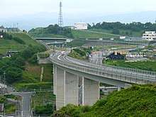
The Keinawa Expressway generally follows the path of Japan National Route 24 from Kyoto to Wakayama. It begins at an interchange with the Shin-Meishin Expressway near Kyoto. From Kyoto the expressway travels south through Nara Prefecture, then crosses into Wakayama where it runs along the southern side of the Kisen Alps while travelling southwest towards Wakayama where it comes to an end at a junction with the Hanwa Expressway. There are some gaps in the expressway that are linked by the previously named national highway. The purpose of this route is to serve as a high-speed route from Kyoto to Wakayama, bypassing Osaka to the west.
Naming
The name Keinawa is a kanji acronym of three characters. The first character represents Kyoto (京都), the second Nara (奈良) and the third character represents Wakayama (和歌山). These are the names of the three prefectures in the Kinki region that the Keinawa Expressway links.
History
The highway was first proposed in 1973 as bypasses in the Kinki region that were not connected. The first section of the expressway connecting Jōyō, Kyoto and Kyotanabe, Kyoto was opened in 1988.[2] The most recent section to open as of May 2018 was between the southern terminus with the Hanwa Expressway and Iwade-Negoro in Wakayama.[3]
Junction list
| Prefecture | Location | km | mi | Exit | Name | Destinations | Notes |
|---|---|---|---|---|---|---|---|
| Kyoto | Kumiyama | Planned | |||||
| Jōyō | 0 | 0.0 | 9 | Jōyō | |||
| Kyōtanabe | 1.6 | 0.99 | 2 | Tanabe-kita | Kyoto Prefecture Route 22 – Kyōtanabe, Kizu | ||
| 5.1 | 3.2 | 3 | Tanabe-nishi | Northbound tollbooth | |||
| Seika | 9.0 | 5.6 | 4 | Seika-shimokoma | Southbound tollbooth | ||
| Kizugawa | 12.4 | 7.7 | 5 | Seika-Gakken | Kyoto Prefecture Route 72 – Kizugawa, Nara | ||
| Seika | 4.0 | 2.5 | 6 | Yamadagawa | |||
| Kizugawa | 17.0 | 10.6 | 7 | Kizu | |||
| 12.4 km gap in the expressway, connection is made by | |||||||
| Nara | Yamatokōriyama | 29.4 | 18.3 | 4-2 | Koriyama-shimotsumichi | Access only to and from | |
| Tenri | 31.0 | 19.3 | 8 | Koriyama-minami | Traffic continuing to the Kyoto portion of the Keinawa Expressway must exit here. | ||
| Miyake | 33.3 | 20.7 | — | Miyake | |||
| Tawaramoto | 36.8 | 22.9 | — | Tawaramoto | Nara Prefecture Route 14 | Access is available to Nara Prefecture Route 14 via National Route 24. | |
| Kashihara | 38.8 | 24.1 | 9 | Kashihara-kita | |||
| 4.4 km gap in the expressway, connection is made by | |||||||
| 43.2 | 26.8 | — | Kashira-Takada | ||||
| 46.9 | 29.1 | — | Gose | ||||
| Gose | 49.4 | 30.7 | — | Gose-minami | |||
| Gojō | 56.6 | 35.2 | 10 | Gojō-kita | |||
| 61.1 | 38.0 | 11 | Gojō | ||||
| 63.2 | 39.3 | 12 | Gojō-nishi | ||||
| Wakayama | Hashimoto | 65.3 | 40.6 | 13 | Hashimoto-higashi | ||
| 70.2 | 43.6 | 14 | Hashimoto | ||||
| 75.8 | 47.1 | 15 | Koyaguchi | ||||
| Katsuragi | 79.8 | 49.6 | 16 | Kihoku-Katsuragi | |||
| 81.8 | 50.8 | 17 | Katsuragi-nishi | Wakayama Prefecture Route 125 – Osaka, Izumiōtsu | |||
| Kinokawa | 88.2 | 54.8 | 18 | Kinokawa-higashi | Wakayama Prefecture Route 122 | ||
| 92.7 | 57.6 | 19 | Kinokawa | Wakayama Prefecture Route 62 | |||
| Iwade | 98.4 | 61.1 | 20 | Iwade-Negoro | Wakayama Prefecture Route 63 – Sennan, Iwade | Tollbooth is located on the Wakayama side of the interchange | |
| Wakayama | 101.6 | 63.1 | 20-1 | Wakayama | Access to/from Osaka-bound traffic only | ||
| 104.9 | 65.2 | 20-1 | Wakayama | Access to/from Shirahama-bound traffic only | |||
1.000 mi = 1.609 km; 1.000 km = 0.621 mi
| |||||||
References
- ↑ "Japan's Expressway Numbering System". Mlit.go.jp.
- ↑ "平成20年度予算の新規事業採択について" (PDF). Kkr.mlit.go.jp. Retrieved 26 August 2018.
- ↑ "京け い奈和な わ自動車道 紀北西き ほ く に し道路3月18日(土)岩出い わ で根来ね ご ろIC~和歌山わ か やまJCTが開通します!~今回の開通により、阪和自動車道・京奈和自動車道が接続~" (PDF). Kkr.mlit.go.jp. Retrieved 26 August 2018.