Shijōnawate, Osaka
| Shijōnawate 四條畷市 | |||
|---|---|---|---|
| City | |||
 | |||
| |||
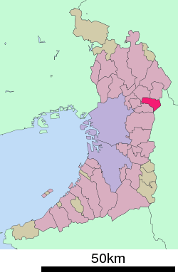 Location of Shijōnawate in Osaka Prefecture | |||
 Shijōnawate Location in Japan | |||
| Coordinates: 34°44′24″N 135°38′22″E / 34.74000°N 135.63944°ECoordinates: 34°44′24″N 135°38′22″E / 34.74000°N 135.63944°E | |||
| Country | Japan | ||
| Region | Kansai | ||
| Prefecture | Osaka Prefecture | ||
| Government | |||
| • Mayor | Kazunori Doi | ||
| Area | |||
| • Total | 18.74 km2 (7.24 sq mi) | ||
| Population (October 1, 2016) | |||
| • Total | 55,832 | ||
| • Density | 3,000/km2 (7,700/sq mi) | ||
| Symbols | |||
| • Tree | Camphor Laurel | ||
| • Flower | Azalea | ||
| Time zone | UTC+9 (JST) | ||
| City hall address |
1-1 Nakanohommachi, Shijōnawate-shi, Ōsaka-fu 575-8501 | ||
| Website |
www | ||


Shijōnawate (四條畷市 Shijōnawate-shi) is a city located in Osaka Prefecture, Japan. The city was founded on July 1, 1970.
As of October 1, 2016, the city has an estimated population of 55,832 and a population density of 3,000 persons per km². The total area is 18.74 km².
Transportation
Railways
(Shijonawate Station is in Daito-shi that is a neighboring city of Shijōnawate-shi.)
Roads
- Route 163
- Route 170
Sister and Friendship cities


See also
External links

- Shijōnawate official website (in Japanese)
| Wards of Osaka | ||
|---|---|---|
| Wards of Sakai | ||
| Core cities | ||
| Special cities | ||
| Cities | ||
| Districts | ||
This article is issued from
Wikipedia.
The text is licensed under Creative Commons - Attribution - Sharealike.
Additional terms may apply for the media files.