Keane Bridge
| Keane Bridge | |
|---|---|
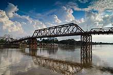 Keane Bridge, 2015 | |
| Coordinates | 24°53′15″N 91°52′05″E / 24.8876°N 91.8681°ECoordinates: 24°53′15″N 91°52′05″E / 24.8876°N 91.8681°E |
| Characteristics | |
| Total length | 350.52 m (1,150.0 ft) |
| Width | 5.4 m (17.7 ft) |
| History | |
| Opened | 1936 |
The Keane Bridge is a notable landmark of Sylhet city, Bangladesh. This bridge is called the gateway to Sylhet city.
Location
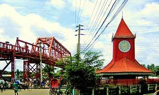
Keane Bridge and Ali Amjad's Clock
This bridge is located over the Surma River at the middle of Sylhet city which is 246 kilometres (153 mi) northeast of Dhaka, the capital of Bangladesh.
History
This bridge was built in 1936 and is named after Sir Michael Keane who was the English Governor of Assam from 1932 to 1937.[1]
Structure
It is made of iron and steel and looks like a bow. The bridge is 1150 feet long and 18 feet breadth. About Taka 5.6 million was spent to build the bridge.[2]
Damage and repair
During the Bangladesh Liberation War the bridge was blown off with dynamite by the Pakistan Army and damaged. It was repaired in 1977.[3]
Gallery
.jpg) North entrance
North entrance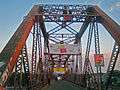
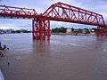 From south
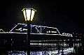 Keane Bridge views at night
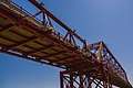
References
- ↑ "Keane Bridge Sylhet". Yogsutra.com. Retrieved 8 December 2012.
- ↑ "Welcome to Kean Bridge - Sylhet, Bangladesh". Tourtobangladesh.com. Retrieved 8 December 2012.
- ↑ Bangladesh (11 October 2008). "The Sylhet Times". Sylhettimesdigital.co.uk. Retrieved 8 December 2012.
External links
| Wikimedia Commons has media related to Keane Bridge. |
This article is issued from
Wikipedia.
The text is licensed under Creative Commons - Attribution - Sharealike.
Additional terms may apply for the media files.