Kayakkunn
| Kayakkunnu (കായക്കുന്ന്) | |
|---|---|
| Village | |
| Coordinates: 11°44′20″N 76°7′15″E / 11.73889°N 76.12083°ECoordinates: 11°44′20″N 76°7′15″E / 11.73889°N 76.12083°E | |
| Country | India |
| State | Kerala |
| District | Wayanad |
| Government | |
| • District Collector | S Suhas IAS |
| • DistrictPanchayatPresident | Ushakumari |
| • District M.L.A's |
Sulthan Bathery : I.C Balakrishnan Kalpetta: C K Saseendran Mananthavady : O.R Kelu |
| Languages | |
| • Official | Malayalam, English |
| Time zone | UTC+5:30 (IST) |
| PIN No | 670721 |
| ISO 3166 code | IN-KL |
| Vehicle registration | KL-12, KL-72, KL-73 |
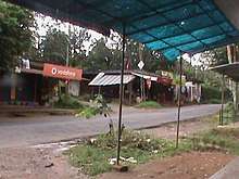
Kayakkunnu (Malayalam: കായക്കുന്ന്) is a village near Nadavayal, Mananthavady in the Wayanad District of Kerala, India. The village is part of the Panamaram Panchayath, and the assembly constituency is Mananthavady (North Wayanad). It is an agricultural area and its main crops include rice, coffee, pepper, ginger, cardamom, vanilla, rubber, areca nut, and coconut. The nearest towns are Nadavayal and Panamaram. Kayakkunn is situated midway along the Mananthavady–Gudalur interstate road.
Geography
Kayakkunn is a village and one of the main residential areas in the Wayanad district of Kerala, which reaches from Panamaram to Mananthavady along the Sultan Battery State Highway.
Agriculture is the primary source of income, and crops include rice, coconut, coffee, pepper, ginger, cardamom, vanilla, rubber, areca nut, and cocoa beans.
Etymology
Oral history and ancient texts state that the area was known by the name of Muthangadi and that it was later known as Puthangadi, a pearl trade center.
History
Most of the population are early immigrants from Mid-Travancore (മധ്യതിരുവിതാംകൂര്) especially in the Kottayam district in central Wayanad. People also immigrated from Malappuram and Mysuru (ಮೈಸೂರು) Karnataka districts to live here.
There are some historical ruins in the area. The oldest are found in nearby Kallambalam and believed to date to Tipu's release.
Transportation
Kayakkunn's main transportation routes are the Sultan Battery State Highway from Mananthavady or Kalpetta. The Periya ghat road connects Mananthavady to Kannur and Thalassery. The Thamarassery mountain road (NH-212) connects Calicut with Kalpetta. The Kuttiady mountain road connects Vatakara with Kalpetta and Mananthavady. The Palchuram mountain road connects Kannur and Iritty with Mananthavady.
The road from Bangalore, Mysore, Gudaloor-Nilgiris, Nilambur, and Ooty is also connected to Wayanad through Sultan battery, Nadavayal-Changanacherry K.S.R.T.C.
There is a daily bus which travels the Sultan Battery highway to connect with the Bangalore–Ooty interstate road. A Pala–Pathanamthitta–Pulpally bus also travels along this route.
The nearest railway stations are at Mysore, Calicut, and Cannanoor. And the nearest airports are Kozhikode International Airport, 3 hours away,[1] Kannur International Airport, 2.5 hours away, and ಬೆಂಗಳೂರು Karnataka Kempegowda International Airport[2] 6.5 hours away.
Landmarks
- Cross church Kayakkunn
- Kayakkunn Ancient Stone Temple[3] Kayakkunn Vishnugudi temple[4]
- La-salatte Monastery[5] (New Shrine in Kerala, India – lasalette)[6][7]
- Kayakkunn Post Office
- Sisters of the Destitute[8] convent
- Wynad Club
- Vayojana Vedi (old age society)
- Vanitha Fruits and Vegetables co-operative society
- "Flora" Mushroom Cultivation Industry
- Blind society
- Milma, Milk marketing Co-operative society
- Agricultural Nursery
- Aumgunvady
Gallery
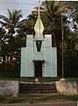 Kayakkunn Chapel (shrine)
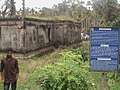 Kayakkunn stone temple
 Wayanad Club
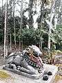 Bull Statue, Punchavayal
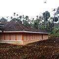 Punchavayal temple
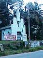 side view of (shrine) Kayakkunn Chapel
| Wikimedia Commons has media related to Kayakkunn. |
References
- ↑ http://www.bengaluruairport.com
- ↑ http://www.bengaluruairport.com
- ↑ https://www.google.co.in/maps/place/Ancient+Jain+Temple+Ruins/@11.7530934,75.8160455,10z/data=!4m8!1m2!2m1!1sjain+temple!3m4!1s0x3ba5e06d898d270d:0xc0f7903473535765!8m2!3d11.7530934!4d76.0961969
- ↑ Vishnugudi-Vishnu-temple-in-Wayanad-now-a-national-monument.html
- ↑ https://www.lasalette.org/about-la-salette/la-salette-news/la-salette-news-worldwide/1801-new-shrine-in-kerala-india.html
- ↑ http://www.lasaletteindia.org/view_page.php?/LA-SALETTE-ASHRAM/&page_id=8
- ↑ https://www.google.co.in/maps/place/La+Salette+Ashram,+Panamaram+-+Nadavayal+-+Kenichira+-+Bathery,+Kerala+670721/@11.7513027,76.0966261,17z/data=!3m1!4b1!4m5!3m4!1s0x3ba5e06d38585637:0xa471820d022cc3fb!8m2!3d11.7512165!4d76.0987416
- ↑ http://www.diocesemdy.org/
| History of Wayanad | |||||
|---|---|---|---|---|---|
| Cities | |||||
| Transport |
| ||||
| Education in Wayanad |
| ||||
| Visitor attractions | |||||
| Places of worship | |||||
| Other topics | |||||
| |||||