Clarence River (New Zealand)
| Waiau Toa / Clarence River | |
|---|---|
 A view over the river mouth near Kaikoura | |
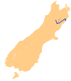 The Clarence River system. | |
| Country | New Zealand |
| Location | Canterbury region, South Island |
| Physical characteristics | |
| Main source | Lake Tennyson, Saint James Range, Spencer Mountains |
| River mouth |
Pacific Ocean Sea level |
| Length | 230 km (140 mi) |
| Basin features | |
| Progression | Overall east |
| River system | Clarence River system |
| Tributaries |
|
The Waiau Toa / Clarence River is on northeast South Island of New Zealand. It is 230 kilometres (140 mi) long, which makes it the eighth longest river in New Zealand.
For its first 50 kilometres (31 mi), the river runs in a generally southeastern direction. It then turns northeast, running down a long straight valley between the Inland and Seaward Kaikoura Ranges. At the end of the Seaward Kaikouras, the river meanders through undulating hill country before draining into the Pacific Ocean near the town of Clarence. A large part of the river is within the boundaries of Molesworth Station.
Northern tributaries along the middle segment of Waiau Toa / Clarence River (e.g., Mead Stream, Dee Stream, Branch Stream, Muzzle Stream) cut through an uplifted, folded and rotated block of limestone and marl that accumulated on the seafloor from the late Cretaceous through the Paleocene and middle Eocene (75–45 million years ago). Exposures of this limestone—the Amuri Limestone—provide some of the most complete records for this time interval of Earth's history. They have provided important insights to our understanding of the Paleocene-Eocene Thermal Maximum (PETM), Eocene Thermal Maximum 2 (ETM-2), and other Paleogene hyperthermal events [1] [2] [3]
A slip triggered by the 2016 Kaikoura earthquake blocked the Waiau Toa / Clarence River 10 to 12 km from its mouth, with water building up behind the slip. Residents near the river downstream from the slip were evacuated. The river broke through the debris 16 hours after it occurred.[4]
In 2018, the name of the river was officially gazetted as Waiau Toa / Clarence River, to reflect its original Māori name.[5]
References
- ↑ Hollis, C.J.; Gerald R. Dickens; Bradley D. Field; Craig M. Jones; C. Percy Strong (2005). "The Paleocene-Eocene transition at Mead Stream, New Zealand: a southern Pacific record of early Cenozoic global change". Palaeogeography, Palaeoclimatology, Palaeoecology. 215: 313–343. doi:10.1016/j.palaeo.2004.09.011.
- ↑ Nicolo, M.J.; Gerald R. Dickens; Christopher J. Hollis; James C. Zachos (2007). "Multiple early Eocene hyperthermals: Their sedimentary expression on the New Zealand continental margin and in the deep sea". Geology. 35: 699–702. Bibcode:2007Geo....35..699N. doi:10.1130/g23648a.1.
- ↑ Slotnick, B.S.; Gerald R. Dickens; Micah J. Nicolo; Christopher J. Hollis; James S. Crampton; James C. Zachos; Appy Sluijs (2012). "Large-amplitude variations in carbon cycling and terrestrial weathering during the Latest Paleocene and Earliest Eocene: The record at Mead Stream, New Zealand". Journal of Geology. 120: 487–505. Bibcode:2012JG....120..487S. doi:10.1086/666743.
- ↑ "Clarence River: Slip causes breach after earthquake damage". The New Zealand Herald. 14 November 2016. Retrieved 14 November 2016.
- ↑ "Waiau Toa / Clarence River". Land Information New Zealand. 18 January 2018. Retrieved 30 January 2018.