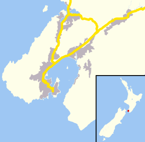
Karori
| Karori | |
|---|---|
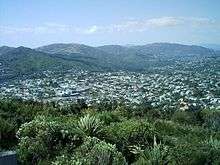 City-end Karori from Wrights Hill summit | |
 Karori | |
| Basic information | |
| Local authority | Wellington City |
| Electoral ward | Onslow-Western |
| Date established | 1840 |
| Land area | 1,726 ha (6.66 sq mi)[1] |
| Coordinates | 41°17′05″S 174°44′12″E / 41.284855°S 174.736795°ECoordinates: 41°17′05″S 174°44′12″E / 41.284855°S 174.736795°E |
| Population | 14,736[1] (2013) |
| Postcode(s) | 6012 |
| Surrounds | |
| Northeast | Wilton |
| East | Northland |
| Southeast | Highbury, Taitville |
| Northwest | Makara |
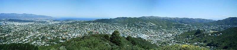
Karori is a suburb located at the western edge of the urban area of Wellington, New Zealand, 4 km from the city centre[2] and is one of New Zealand's biggest suburbs[2] having a population of over 14,000 at the time of the 2013 census.[1]
History
Origins
The name Karori means "the rope of bird snares" in te reo Māori.[3]
No Māori lived in the area[4] when the first European settlers came to Karori in the 1840s, having bought the land from the New Zealand Company. The first settler in Karori, John Yule of Glasgow,[5] cleared 20 acres of forest on his section with his younger brother Moses and advertised its sale in December 1841.[6]:9 By 1845, ten 100-acre sections were being taken up and sub-divided, and Karori recorded 215 inhabitants – 109 of them under the age of 14 years.[6]:11
In 1845 a group of armed police from Wellington constructed a small fortified post that became known as "The Stockade" in response to fears of attacks from nearby Māori insurgents. While there were no attacks, the stockade was used for a church service and to grind grain.[6]:15 The stockade was located on Mr Chapman's land, about halfway along what is now Marsden Avenue.[7]
The first mental hospital in Wellington was built in 1854.[6]:17 By 1871 it had 23 inmates and was run by untrained staff, which resulted in the first matron and her husband being dismissed in 1872 because of cruelty.[5] In 1873 the asylum moved from Karori to the site of present-day Government House in central Wellington.[5] Karori School took over the asylum site in 1875.[6]:23
Frederick Mackie in his book Traveller under concern described Karori in the 1850s:
- "The walk was highly romantic. The road is cut out of the sides of steep hills covered with forest. The ever-winding road, the steep declivities, the forest above and below you, and the continual murmur of streams concealed in the depths below were very pleasing, as every few yards a new scene and fresh objects were brought to view. In one spot I obtained a view of the harbour, which today was like a bright glassy lake, and beyond it were the lofty ranges of the snow-clad Rimutaka and Tararuas, partly glistening in the sun and partly shrouded in cloud."[8]
Karori gold rush
Karori experienced a gold rush when the valley of the Upper Kaiwharawhara Stream became subject to intensive gold-mining activity between 1869 and 1873. This activity eventually led to the building of the lower Karori Dam in 1873.[9] At the height of the rush about 200 men worked the claims, driving shafts and drives up to 500 feet in length into the hills.[6]:29
Growth and subdivision
In 1888 a syndicate purchased section 34, which was the closest to town (running from present day Ponsonby Road to Cooper Street). The new owners prepared the land for sale by building roads and naming them after the members of the syndicate and their families, and by running a marketing campaign, including providing free buses from Manners Street and writing poems:
In far-famed New Zealand, the evergreen free land
Most favoured and beautiful Queen of the wave,
Where the sun ever smiling, bad weather beguiling,
Brightly shines on the face of the honest and brave.
Tho' for Europe's bold races there are plenty of places
Adapted as homes for the great and the small,
Yet, for onward progressing and bountiful blessing
There is one whose position is far before all.
So haste where kind Nature's arrayed in her glory,
To pleasant, romantic, suburban Karori.[6]:30–31
Karori Borough, 1891–1920
Karori was declared a borough in 1891 following a petition in favour of forming a borough with 123 signatories. A counter-petition garnered 41 signatories.[6]:31–32
List of Mayors of Karori Borough
| # | Name | Term |
|---|---|---|
| 1 | Stephen Lancaster | 1891–1894 |
| 2 | Richard Bulkley | 1894–1901 |
| 3 | F.J. McDonald | 1901–1902 |
| 4 | E.C Farr | 1902 |
| 5 | J.B. Tarr | 1902–1903 |
| 6 | W.H. Tisdall | 1903–1904 |
| 7 | A.C. Pearce | 1904–1908 |
| 8 | C. A. Dasent | 1908–1911 |
| 9 | C. Cathie | 1911–1914 |
| 10 | W.T Hildreth | 1914–1915 |
| 11 | B.G.H. Burn | 1915–1920 |
Amalgamation with Wellington, 1920
Both Wellington and Karori expanded towards each other, the two urban areas becoming gradually connected, aided by the construction of the Karori tunnel in 1901,[10] and the Borough of Karori amalgamated with the City of Wellington in 1920.[11]
Karori sport teams
Waterside Karori association football club founded when Karori Swifts and Waterside ( a club based in Kaiwharawhara) merged.[12]
Facilities

Parks and reserves
Zealandia (formerly called the Karori Wildlife Sanctuary) is an enclosed restoration project focusing on the flora and fauna that inhabited the valley before human settlement.[18]
Karori Park, on Karori Road features a football and cricket sports ground, all-weather track, changing rooms and play area.[19]
Ben Burn Park, on Campbell Street features a football and cricket sports ground, changing rooms, athletics, play area and artificial cricket surfaces.[19]
Wrights Hill Reserve in southern Karori features mountain bike and walking tracks and the historic Wrights Hill Fortress with a network of tunnels and gun emplacements overlooking the valley.[20]
Makara Peak Mountain Bike Park in southern Karori has over 40 km of mountain bike and walking tracks built by the mountain biking community and is recognised as a world-class area dedicated to mountain biking.[21]
Karori pool
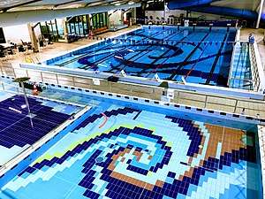
Karori pool is a modern indoor swimming complex with a 25 meter heating pool, learners' pool, toddlers pool, spa pool and a 30 meter hydro-slide.[22] The pool was originally an outdoor facility first opened in 1936.[23] The pool was converted to an indoor pool in 2001[24] and additional work in 2010 added the hydro-slide.[25] The pool is home to the Karori Pirates swimming club.[26]
Shopping
The centre of Karori contains a shopping mall, café, and other amenities.
Library
Karori Library first opened in the 1840s, operating out of the community hall at the site of the present day library on Karori Road. In November 2005, the current two level library and cafe was opened.[27]
Community garden
Karori also has a community garden, started in 2015.[28]
Churches and cemeteries
Karori Cemetery is the second largest and second oldest cemetery in New Zealand.[10] Opened in 1891, it replaced the cemetery at Bolton Street as the main burial ground for the inhabitants of Wellington. It covers 100 acres / 40 hectares. The Small Chapel contains excellent stained glass windows designed by Wilhelmina Geddes. The cemetery contains the war graves of 267 Commonwealth service personnel of World War I and 123 of World War II, in separate plots for each war, the plots being linked by the Wellington Provincial Memorial (in the form of a marble archway) which commemorates 65 World War I and 20 World War II military personnel from the Wellington Military District who died abroad and have no known grave (most were buried at sea).[29] Karori Cemetery "closed" in 1965 for the establishment of new burial plots but interments in established graves continues.
Futuna Chapel, built in 1961 by the Society of Mary, was awarded New Zealand Institute of Architects Gold medal for best building in 1968.[30] The chapel was deconsecrated in 2000 and was sold to a property developer who planned to clear the section for residential development.[30] The building was saved when it was listed as a heritage building and is being restored by a Charitable Trust.[31]
Other churches in Karori include:
Public transport
Until 31 October 2017, the full length of Karori Road was served by the Karori Park trolley bus route, which replaced the former tram service in 1954. For many years vehicles on this route ran as route 12 to Courtenay Place, but are now designated as route 3 and through-routed to and from Lyall Bay via the city. The weekday 10-minute service is the most-frequent of all Wellington routes. Other routes serving the suburb are route 17 which runs through Kelburn to Thorndon and the Railway Station, route 18 which serves the eastern side of the suburb and runs through Te Aro, route 21 that runs up Birdwood St, and down Campbell St, and route 47 that runs to the Johnsonville shopping centre.
Additionally there are express buses, Karori South and Karori West buses.
Education
School enrolment zone
Karori is within the enrolment zones for Wellington College, Wellington Girls' College, Wellington High School, St Oran's College, Karori West Normal School, and Karori Normal School.[38]
University
The former Karori campus of Victoria University of Wellington on Donald Street was the home of the Faculty of Education until 2016 when the Faculty moved to the Kelburn campus.
Secondary school
Samuel Marsden Collegiate School is a composite private Anglican girls' school on Karori Road in Marsden Village. It offers classes from new entrants to Year 13. In 2014 it had a roll of 502.[39]
Primary schools
There are three primary schools in Karori.
St Teresa's School is a decile 10[40] full primary integrated school which serves the Catholic population of the suburb. In 2014 it had a roll of 178.[39]
Karori West Normal School is a decile 10[40] full state primary school in Allington Road which serves the western end of the suburb. In 2014 it had a roll of 461.[39]
Karori Normal School is a decile 10[40] full state primary school in Donald Street which serves the eastern and central part of the suburb. It was founded in 1857 and is the second largest full primary school in New Zealand with a roll of 745 in 2014.[39] It has an artificial turf, two playgrounds, 35 classrooms in approximately four buildings, a concrete field, and a grass field. Students from Year 1–8 attend. The author Katherine Mansfield attended the school from 1895–98[41] and there is a memorial to her at the school on a concrete field called the Katherine Mansfield field, located in front of a tree she wrote about in one of her stories.
Preschools
There are a number of preschool education providers in Karori, including:
- Karori Playcentre
- Marsden Preschool
- Karori Kindercare[42]
- Donald Street Preschool[43]
- Karori Kids Preschool[44]
- Karori Childcare Centre[45]
- Karori Plunket Creche
- St Mary’s Early Childhood Education Centre[46]
- Sunshine Kindergarten
- Kiwi Kids Preschool
References
| Wikimedia Commons has media related to Karori. |
- 1 2 3 "Community Profile: Karori".
- 1 2 Jago, Francesca (16 December 2014). "Let's live in... Karori". Stuff. Retrieved 15 March 2015.
- ↑ Maclean, Chris. "Story: Wellington places – Page 4 – Western suburbs". Te Ara – The Encyclopedia of New Zealand. Retrieved 15 March 2015.
- ↑ Brodie, J (1973). "The Stockade Vol. 1 No. 1". Karori Historical Society. p. 3. Retrieved 15 March 2015.
- 1 2 3 Dekker, Diana (30 July 2011). "Conquering Karori". The Dominion Post. Retrieved 17 March 2015.
- 1 2 3 4 5 6 7 8 Patrick, Margaret (1990). From Bush to Suburb, Karori 1840–1980. The Karori Historical Society (Inc).
- ↑ Karori Stockade, retrieved 25 July 2017
- ↑ Mackie, Frederick (1973). Traveller under concern: the Quaker journals of Frederick Mackie on his tour of the Australasian colonies, 1852–1855. University of Tasmania. p. 119. ISBN 0859010074.
- ↑ Brodie, James (1997). The Karori Gold Rush 1869–1873. The Karori Historical Society (Inc). ISBN 0-473-04773-X.
- 1 2 Rutherford, Rebecca (19 July 2013). "Early access to the Western hills". The Wellingtonian. Retrieved 15 March 2015.
- ↑ "Karori". Wellington Local History. Wellington City Libraries. Retrieved 2010-11-11.
- ↑ "Waterside Karori". Wikipedia. Wikipedia, the free encyclopedia. Retrieved 1 October 2018.
- ↑ "Karori United Tennis Club". Retrieved 1 October 2018.
- ↑ "Karori Amateur Athletics Club". Karori Amateur Athletics Club. SportsTG. Retrieved 1 October 2018.
Welcome to Karori Athletics – over 100 years of athletics in Karori
- ↑ "Karori Cricket Club". Karori Cricket Club. Karori Cricket Club. Retrieved 1 October 2018.
- ↑ "Karori Netball Club". Karori Netball Club. SportsTG. Retrieved 1 October 2018.
- ↑ "Karori Bowling Club". Karori Bowling Club. Sporty. Retrieved 1 October 2018.
- ↑ "Zealandia". Retrieved 15 March 2015.
- 1 2 "Sportsgrounds Locations". Wellington City Council. Retrieved 15 March 2015.
- ↑ "Wrights Hill". Wellington City Council. Retrieved 15 March 2015.
- ↑ "Makara Peak Mountain Bike Park". Wellington City Council. Retrieved 15 March 2015.
- ↑ "Karori Pool". Wellington City Council. Retrieved 5 October 2015.
- ↑ Thomson, Rebecca (October 2, 2015). "Mayor takes a dive into Karori's new pool – 150 Years of News". Stuff. Retrieved 5 October 2015.
- ↑ "Karori Heritage". Wellington City Libraries. Retrieved 5 October 2015.
- ↑ Revington, Ann (18 March 2010). "Karori hydroslides into Capital's aquatic history". Newswire. Retrieved 5 October 2015.
- ↑ "Karori Pirates". Retrieved 5 October 2015.
- ↑ "About Karori Library". Wellington City Libraries. Retrieved 15 March 2015.
- ↑ "Karori Community Garden – CommunityFinder". www.communityfinder.org.nz. Retrieved 2017-11-29.
- ↑ "Wellington Provincial Memorial". Commonwealth War Graves Commission. Retrieved 15 March 2015.
- 1 2 "Futuna Chapel Special" (PDF). Retrieved 17 March 2015.
- ↑ "Karori's hidden treasure". The Dominion Post. 12 March 2011. Retrieved 17 March 2015.
- ↑ "Karori Anglican Church". Retrieved 17 March 2015.
- ↑ "Karori Baptist Church". Retrieved 17 March 2015.
- ↑ "Catholic Church St Theresa". Retrieved 17 March 2015.
- ↑ "St Anselms Union Church". Retrieved 17 March 2015.
- ↑ "St Ninians Uniting". Retrieved 17 March 2015.
- ↑ "St Mary's Anglican Church". Retrieved 17 March 2015.
- ↑ "eLearning Schools Search". Ministry of Education.
- 1 2 3 4 "Student Rolls by School 2010–2014". Ministry of Education New Zealand. Archived from the original on 15 January 2015. Retrieved 14 March 2015.
- 1 2 3 "Decile Change 2014 to 2015 for State & State Integrated Schools". Ministry of Education. Retrieved 15 March 2015.
- ↑ "Katherine Mansfield's Timeline". Katherine Mansfield Society. Retrieved 15 March 2015.
- ↑ "Karori Kindercare". Retrieved 15 March 2015.
- ↑ "Donald Street Preschool". Retrieved 15 March 2015.
- ↑ "Karori Kids Preschool". Retrieved 15 March 2015.
- ↑ "Karori Childcare Centre". Retrieved 15 March 2015.
- ↑ "St Mary's Early Childhood Education Centre". Retrieved 15 March 2015.