Kapiti Expressway
| |
|---|---|
| State Highway 1 | |
| Route information | |
| Maintained by NZ Transport Agency | |
| Length | 18 km (11 mi) |
| History | 24 February 2017–present |
| Major junctions | |
| North end |
|
| South end |
|
| Location | |
| Primary destinations | Peka Peka, Waikanae, Paraparaumu, Raumati |
| Highway system | |

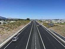
The Kapiti Expressway is a four-lane grade-separated expressway through the Kapiti Coast, north of Wellington, New Zealand. As of February 2017, it stretches 18 km (11 mi) from Mackays Crossing north of Paekakariki to just north of Peka Peka, bypassing the former two-lane route through Raumati, Paraparaumu, and Waikanae. Construction of a 14 km (8.7 mi) northern extension to just north of Otaki, bypassing Te Horo and Otaki, is expected to start construction in mid-2017.
Construction
The section from just south of Mackays Crossing to just south of Poplar Avenue at Raumati South was completed in 2007 with the completion of the Mackays Crossing interchange and rail overbridge, bypassing the existing rail level crossing. The previously constructed four-lane section from Mackays Crossing to Poplar Avenue was upgraded during 2016 and early 2017 to provide an improved road surface. This section of road is constructed on an old peat swamp and develops an uneven surface over time.
Work on the Raumati to Peka Peka section started in December 2013.[1] The official opening ceremony was held on 16 February 2017, and the expressway opened to traffic in the early hours of 24 February 2017, some three months ahead of the original scheduled date. Some works, including the final layer of asphalt on some sections and roundabouts at the Peka Peka and Poplar Avenue interchanges, will take until mid-2017 to complete.[2][3]
The first sod was turned on the Peka Peka to Otaki section on 6 July 2017 and will finish in 2020.
Exit list
| Location | km | Destination(s) | Notes |
|---|---|---|---|
| Otaki | 998.5 | Stage 2 northern terminus | |
| 999.8 | Main Highway – Otaki | Southbound exit and northbound entrance | |
| 1001.7 | Otaki River | ||
| 1002.1 | Otaki Gorge Road – Otaki | Northbound exit and southbound entrance | |
| Currently terminates north of Peka Peka Road | |||
| Peka Peka | 1012 | Peka Peka Road – Peka Peka, Waikanae | Southbound exit and northbound entrance 40°50′26″S 175°05′12″E / 40.8406°S 175.0868°E |
| Waikanae | 1017 | Te Moana Road – Waikanae, Waikanae Beach | 40°52′04″S 175°02′01″E / 40.8677°S 175.0335°E |
| 1018.4 | Waikanae River | 40°52′40″S 175°01′40″E / 40.8777°S 175.0279°E | |
| Paraparaumu | 1023 | Kapiti Road – Paraparaumu, Paraparaumu Beach | 40°54′30″S 174°59′59″E / 40.9084°S 174.9997°E |
| Raumati | 1026.6 | Poplar Avenue – Raumati, Paraparaumu | Northbound exit and southbound entrance 40°56′23″S 174°59′35″E / 40.9398°S 174.9931°E |
| Mackays Crossing | 1030.3 | Whareroa Road – Queen Elizabeth Park | 40°58′15″S 174°58′59″E / 40.9709°S 174.9830°E |
| Southern terminus | |||
1.000 mi = 1.609 km; 1.000 km = 0.621 mi
| |||
References
- ↑ "Work starts on MacKays to Peka Peka expressway". Fairfax New Zealand (via Stuff.co.nz). 2 December 2013. Retrieved 28 December 2014.
- ↑ Maxwell, Joel (7 February 2017). "Kapiti expressway gets official completion date of February 16". Stuff.co.nz. Retrieved 8 February 2017.
- ↑ Haxton, David (16 February 2017). "Mackays to Peka Peka Expressway north of Wellington opens". nzherald.co.nz (via Kapiti News). Retrieved 17 February 2017.