Upper Harbour Bridge

The Upper Harbour Bridge (also called the Greenhithe Bridge) is a motorway bridge in west Auckland, New Zealand. It is technically two bridges, spanning an upper reach of the Waitematā Harbour, and connecting Hobsonville (in Waitakere City) and Greenhithe (in North Shore City). It is an important connection for State Highway 18, and became even more important as a component of the Western Ring Route when the route was completed on 2 July 2017.[1]
History
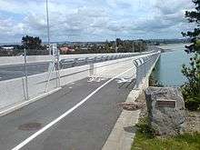
The original bridge was built in the 1970s. Its capacity proved insufficient for later traffic demands of more than 27,000 vehicles per day[2] (soon to be up to 35,000 vehicles per day with the completion of the motorway works)[3] and a duplicate bridge was constructed next to it. The new bridge was designed and engineered by Beca, and built between 2005-2006 by Fletcher Construction using self-compacting concrete.[4] The new bridge cost NZ$35 million[3] and provides a 524 m long, 16.5m wide, 10-span crossing. This was designed to match the existing 457 m long existing 7-span cantilever bridge aesthetically.[5][6]
The bridges provide three lanes toward Greenhithe (an uphill gradient) and two lanes downhill. Prior to the first stage of the Upper Harbour Motorway opening, Transit NZ closed off the old bridge to make repairs, especially to reduce a sagging effect due to old tensioning cables.[7] With the opening of the motorway on 6 December 2007 all bridge lanes were open.[3] The new bridge also provides a cycle-way and walkway on the north side.[2]
The bridge project, together with the causeway widening, has received a Silver Award from the Association of Consulting Engineers New Zealand.[6]
The original bridge was in 1986 used by A. J. Hackett for the first jumps testing the equipment for what was to eventually become the world's first commercial bungee jumping company.[8]
References
- ↑ "Auckland's Waterview Tunnel open to traffic at last". Stuff.co.nz. 2 July 2017. Retrieved 7 September 2017.
- 1 2 Work on Upper Harbour Corridor Begins (official website of the New Zealand Parliament)
- 1 2 3 New SH18 Greenhithe motorway opens up growth opportunities - Transit New Zealand, Media Release, Thursday 6 December 2007. Accessed 2008-01-16.
- ↑ Upper Harbour Bridge datasheet (from the New Zealand Concrete Society website)
- ↑ Upper Harbour duplicate bridge (from the Fletcher Construction website)
- 1 2 Upper Harbour Bridge Duplication & Causeway Widening - Innovate NZ, Brochure of the '2007 ACENZ Awards of Excellence', Page 19
- ↑ Falconer, Phoebe (6 June 2006). "Get moving: New bridge open, now the old one's closed". The New Zealand Herald. Retrieved 26 November 2011.
- ↑ "Can you Hackett?". Unlimited - Inspiring Business. 23 August 2004. Archived from the original on 17 July 2011. Retrieved 20 July 2010.
Coordinates: 36°47′06″S 174°40′04″E / 36.784903°S 174.667801°E