Levin, New Zealand
| Levin Taitoko (Māori) | |
|---|---|
| Secondary urban area | |
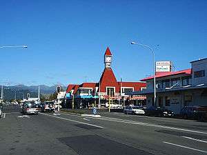 Intersection of Queen and Oxford Streets | |
 Levin | |
| Coordinates: 40°37′19″S 175°17′12″E / 40.62194°S 175.28667°ECoordinates: 40°37′19″S 175°17′12″E / 40.62194°S 175.28667°E | |
| Country | New Zealand |
| Region | Manawatu-Wanganui |
| Territorial authority | Horowhenua District |
| Ward | Levin Ward |
| Named for | William Hort Levin |
| Area | |
| • Urban | 109.02 km2 (42.09 sq mi) |
| Population (June 2017)[1] | |
| • Urban | 20,900 |
| • Urban density | 190/km2 (500/sq mi) |
| Postcode | 5510 |
| Area code(s) | 06 |
Levin (Māori: Taitoko) is the largest town and seat of the Horowhenua District, in the Manawatu-Wanganui region of New Zealand's North Island. It is located east of Lake Horowhenua, around 95 km north of Wellington and 50 km southwest of Palmerston North.
The town has a population of 20,900 (June 2017),[1] making it the 22nd largest urban area in New Zealand, and third largest in Manawatu-Wanganui behind Palmerston North and Whanganui.
Levin is a service centre for the surrounding rural area, and a centre for light manufacturing.
Population
According to June 2017 figures, the estimated resident population was 20,900.[2] Over 20% of inhabitants were listed as over the age of 65, a considerably higher percentage than the national average.[3] The town celebrated its centenary in 2006 and the bowls club celebrated theirs in 2007.
Origin of name
The town was named after William Hort Levin, a director of the Wellington and Manawatu Railway Company. The name is a variation of the Jewish clan Levi. It is a shibboleth – unlike the usual pronunciation of the surname, stress is placed on the second syllable of the word. However his great grandson, Peter Levin, claims his forbear would have pronounced his surname as in Levene and this pronunciation was in common use for many years and always used by the family.
Transport
Levin lies on State Highway 1, which forms the town's main street, Oxford Street. State Highway 57 forms the eastern boundary of the town, and meets State Highway 1 between Levin and the Ohau River, Wellington.
Levin is on the North Island Main Trunk with a station used by the Capital Connection long distance commuter train between Wellington and Palmerston North.[4] It is also served by 8 InterCity buses a day each way.[5]
Buses run for shoppers to Waikanae on Tuesdays and Thursdays[6] and on Fridays to Shannon, Foxton Beach, Foxton and Waitarere Beach.[7] A commuter bus runs via Foxton to Palmerston North.[6]
Lake Horowhenua
To the west of the main town lies lake Horowhenua. A large lake, covering some 3.9 sq/km. It is currently undergoing cleaning and regeneration.
Schools
Notable people
- Jack Afamasaga - rugby league player
- Sir Paul Beresford - British politician
- Suzy Clarkson - newsreader
- Kay Cohen - fashion designer
- Joy Cowley - novelist
- Cathryn Finlayson - 2012 London Olympian, New Zealand hockey player
- Rebecca Gibney - actress
- Nathan Guy - politician
- Nicky Hager - author
- Darren Hughes - politician
- Dean Kent - Olympic and Commonwealth Games swimmer
- Doug Kidd - politician
- David Lomax - NZ Kiwi rugby league rep, NRL club professional with the Newcastle Knights.
- Johnny Lomax - NZ Kiwi rugby league rep, NRL club professional with Canberra Raiders, Townsville Cowboys.
- Matthew Saunoa - New Zealand Idol winner 2006
- George Silk - photographer, LIFE magazine
- Carlos Spencer - former All Black
- Richard Sylvan - philosopher and logician
- James Tamou - Australian Kangaroo rugby league representative player, NSW State of Origin representative player 2012, 2013; rugby league professional
- Codie Taylor - All Black
- Roger Twose - NZ Black Caps cricket player.
- Sonny Whakarau - NZ Junior Kiwi rugby league representative player, rugby league professional in the UK.
References
- 1 2 "Subnational Population Estimates: At 30 June 2017 (provisional)". Statistics New Zealand. 24 October 2017. Retrieved 24 October 2017. For urban areas, "Subnational population estimates (UA, AU), by age and sex, at 30 June 1996, 2001, 2006-16 (2017 boundary)". Statistics New Zealand. 24 October 2017. Retrieved 24 October 2017.
- ↑ Statistics New Zealand Subnational Population Estimates
- ↑ "Levin age profile, NZ Stats"
- ↑ "Capital Connection". Great Journeys of New Zealand. Retrieved 2018-08-22.
- ↑ "Search Results". www.intercity.co.nz. Retrieved 2018-08-22.
- 1 2 "Did you know Horizons Regional Council provides three public bus services in the Horowhenua District?" (PDF). 15 July 2018.
- ↑ "Day Out in Town Bus timetable change". Retrieved 2018-08-19.