Kandanga, Queensland
| Kandanga Queensland | |
|---|---|
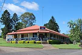 Kandanga Hotel | |
 Kandanga | |
| Coordinates | 26°23′S 152°40′E / 26.383°S 152.667°ECoordinates: 26°23′S 152°40′E / 26.383°S 152.667°E |
| Population | 596 (2006 census)[1] |
| Postcode(s) | 4570 |
| Location | |
| LGA(s) | Gympie Region |
| State electorate(s) | Gympie |
| Federal Division(s) | Wide Bay |
Kandanga is a town in south east Queensland, Australia. The town is located on the Mary Valley Highway, 160 kilometres (99 mi) north of the state capital, Brisbane and 28 kilometres (17 mi) south west of Gympie, on the banks of Kandanga Creek. Part of the Gympie Region local government area, Kandanga at the 2006 census had a population of 596.[1] . The name "Kandanga" is derived from the local Kabi Aboriginal language, meaning a fork or sharp bend of the creek.[2]
Kandanga is one of a chain of towns in the Mary Valley also including Imbil, Amamoor and Dagun.
In 2006 the Beattie state government announced plans to construct a new dam at Traveston Crossing on the upper Mary River. The proposed dam, designed to provide water to the growing Sunshine Coast, was to have flooded fertile farmland, including Kandanga. However, the dam did not proceed on environmental grounds, but not before much of the land required was bought up and the original owners moved on.[3]
Kandanga is well known for its prime farmland, although because of the proposed dam many farmers had to walk out on their farms. A reconstruction plan was implemented following the Traveston Crossing Dam debacle, with farm land subdivided and offered to new owners who have introduced new crops to the Mary Valley.
Kandanga suffered a further blow when its popular hotel burnt down. Just like the valley itself, it is being rebuilt with the determination of locals.
History
Kandanga Post Office opened by June 1914 (a receiving office had been open from 1895).[4]
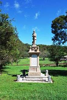
The Kandanga War Memorial was unveiled on 11 November 1920 by the Member of the Queensland Legislative Assembly for the Cooroora Harry Walker.[5]
Heritage listings
Kadanga has a number of heritage-listed sites, including:
References
- 1 2 Australian Bureau of Statistics (25 October 2007). "Kandanga (Cooloola Shire) (State Suburb)". 2006 Census QuickStats. Retrieved 5 July 2008.
- ↑ Mary Valley tourist site - Retrieved 31 October 2006
- ↑ Queensland Government Ministerial Statement 5 July 2006 - Retrieved 31 October 2006
- ↑ Premier Postal History. "Post Office List". Premier Postal Auctions. Retrieved 10 May 2014.
- ↑ "Kandanga War Memorial". Monument Australia. Retrieved 3 April 2014.
- ↑ "Kandanga SS". Retrieved 30 January 2017.
- ↑ "Schools opening dates". Retrieved 30 January 2017.
- ↑ "Mary Valley Railway Cream Sheds (entry 602792)". Queensland Heritage Register. Queensland Heritage Council. Retrieved 8 July 2013.
Further reading
External links
| Wikimedia Commons has media related to Kandanga, Queensland. |