Kama River
Coordinates: 55°21′50″N 49°59′52″E / 55.36389°N 49.99778°E
| Kama | |
|---|---|
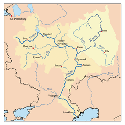 Map of the Volga's watershed with the Kama;s watershed highlighted | |
| Country | Russia |
| Physical characteristics | |
| Main source |
Udmurtia 360 m (1,180 ft) |
| River mouth | Volga River |
| Length | 1,805 km (1,122 mi) |
| Discharge |
|
| Basin features | |
| Basin size | 507,000 km2 (196,000 sq mi) |
The Kama (Russian: река́ Ка́ма, IPA: [rʲɪˈka ˈkamə]; Tatar: Чулман; Udmurt: Кам) is a river 1,805 kilometres (1,122 mi) long[1] in Russia. It is the longest left tributary of the Volga and the largest one in discharge. At their confluence, in fact, the Kama is even larger than the Volga.
It starts in the Udmurt Republic, near Kuliga, flowing northwest for 200 kilometres (120 mi), turning northeast near Loyno for another 200 kilometres (120 mi), then turning south and west in Perm Krai, flowing again through the Udmurt Republic and then through the Republic of Tatarstan, where it meets the Volga.
.jpg)
Before the advent of railroads, important portages connected the Kama with the basins of the Northern Dvina and the Pechora. In the early 19th-century the Northern Ekaterininsky Canal connected the upper Kama with the Vychegda River (a tributary of the Northern Dvina), but was mostly abandoned after just a few years due to low use.
The Kama featured in the 2013 Russian film The Geographer Drank His Globe Away, in the climactic rapids scene.
Dams and reservoirs
The Kama is dammed at several locations:
- At Perm, by the dam of the Kama Hydroelectric Station, forming the Kama Reservoir;
- At Chaykovsky, by the dam of the Votkinsk Hydroelectric Station, forming the Votkinsk Reservoir;
- At Naberezhnye Chelny, by the dam of the Nizhnekamsk Hydroelectric Station, forming the Nizhnekamsk Reservoir.
Gallery
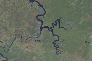 Crossing of the rivers Chusovaya (tributary) and Kama
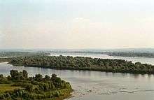 View in Yelabuga
References
- ↑ "Definition of Kama River in English". Oxford Dictionaries. Oxford University Press. Retrieved 11 January 2014.
External links

- Naberezhnye Chelny and the Kama River
Left tributary of the Volga River | ||
| Tributaries | 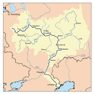 | |
| Reservoirs | ||
| Hydroelectric stations | ||
| Tributaries |
| |
|---|---|---|
| Reservoirs | ||
| Hydroelectric stations | ||
| Canals | ||
| Cities | ||
| ||