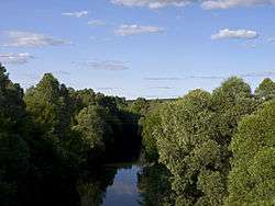
Toyma River
| Toyma, Tuyma River | |
|---|---|
 | |
| Country | Tatarstan and Udmurtia, Russia |
| Physical characteristics | |
| Main source | Udmurtia |
| River mouth |
Kuybyshev Reservoir, Kama River, near Yelabuga, Tatarstan 53 m (174 ft) |
| Length | 124 km (77 mi) |
| Basin features | |
| Basin size | 1,446 km2 (558 sq mi) |
The Toyma (Russian: Тойма; Tatar: Cyrillic Туйма, Latin Tuyma) is a river in Udmurtia and Tatarstan, Russian Federation, a right-bank tributary of the Kama River. It is 124 kilometres (77 mi) long, of which 84 kilometres (52 mi) are in Tatarstan, and its drainage basin covers 1,446 square kilometres (558 sq mi). It begins in Udmurtia and falls to the Kama near Yelabuga, Tatarstan.
Major tributaries are the Vozzhayka, Yurashka, Karinka rivers. The maximal mineralization 400-600 mg/l. The maximal water discharge was 533 cubic metres per second (18,800 cu ft/s) in 1979. Drainage is regulated. Average sediment accumulation at the mouth per year is 146 millimetres (5.7 in). Since 1978 it is protected as a natural monument of Tatarstan. [1] Mendeleyevsk and Yelabuga are along the river.
References
- ↑ (in Tatar) "Туйма". Tatar Encyclopaedia. Kazan: The Republic of Tatarstan Academy of Sciences. Institution of the Tatar Encyclopaedia. 2002.
Left tributary of the Volga River | ||
| Tributaries | 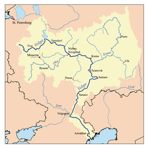 | |
| Reservoirs | ||
| Hydroelectric stations | ||
| Wikimedia Commons has media related to Toyma River. |
Coordinates: 56°19′12″N 52°24′24″E / 56.32000°N 52.40667°E