Kalpowar
| Kalpowar Queensland | |||||||||||||||
|---|---|---|---|---|---|---|---|---|---|---|---|---|---|---|---|
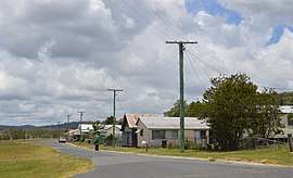 Forest St, the main street of Kalpowar | |||||||||||||||
 Kalpowar | |||||||||||||||
| Coordinates | 24°41′42″S 151°18′18″E / 24.695°S 151.305°ECoordinates: 24°41′42″S 151°18′18″E / 24.695°S 151.305°E | ||||||||||||||
| Postcode(s) | 4630 | ||||||||||||||
| Area | 354.4 km2 (136.8 sq mi) | ||||||||||||||
| LGA(s) | |||||||||||||||
| State electorate(s) | Callide | ||||||||||||||
| Federal Division(s) | Flynn | ||||||||||||||
| |||||||||||||||
Kalpowar is a town in the North Burnett Region and a locality split between the North Burnett Region and the Bundaberg Region, in Queensland, Australia.[1][2][3]
History
The town's name derives from the railway station name assigned by the Queensland Railways Department on 30 January 1928, which was an Aboriginal word meaning either pine tree or copper.[1]
References
- 1 2 "Kalpowar - town in North Burnett Region (entry 17613)". Queensland Place Names. Queensland Government. Retrieved 28 December 2017.
- ↑ "Kalpowar - locality in North Burnett Region (entry 45375)". Queensland Place Names. Queensland Government. Retrieved 28 December 2017.
- ↑ "Kalpowar - locality in Bundaberg Region (entry 44733)". Queensland Place Names. Queensland Government. Retrieved 28 December 2017.
External links
![]()
This article is issued from
Wikipedia.
The text is licensed under Creative Commons - Attribution - Sharealike.
Additional terms may apply for the media files.