Mungungo
| Mungungo Queensland | |
|---|---|
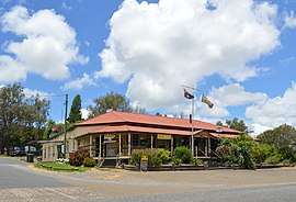 Waratah Hotel at Mungungo, 2017 | |
 Mungungo | |
| Coordinates | 24°46′01″S 151°09′50″E / 24.76694°S 151.16389°ECoordinates: 24°46′01″S 151°09′50″E / 24.76694°S 151.16389°E |
| Population | 77 (2016 census)[1] |
| Postcode(s) | 4630 |
| Location | |
| LGA(s) | North Burnett Region |
| State electorate(s) | Callide |
| Federal Division(s) | Flynn |
Mungungo is a locality in the Wide Bay-Burnett region of Queensland, Australia. The locality is in the North Burnett Region local government area, 488 kilometres (303 mi) north west of the state capital, Brisbane. At the 2016 census, Mungungo had a population of 77.[1]
The Gladstone to Monto railway line reached Mungungo in 1930. The name Mungungo is believed to mean "darkness" or "night" in an unidentified indigenous language. Until 1929, the town was known as Waratah.[2]
References
- 1 2 Australian Bureau of Statistics (27 June 2017). "Mungungo". 2016 Census QuickStats. Retrieved 4 January 2018.

- ↑ "Mungungo - locality in North Burnett Region (entry 23491)". Queensland Place Names. Queensland Government. Retrieved 4 January 2018.
External links
![]()
This article is issued from
Wikipedia.
The text is licensed under Creative Commons - Attribution - Sharealike.
Additional terms may apply for the media files.