Kalanit
| Kalanit | |
|---|---|
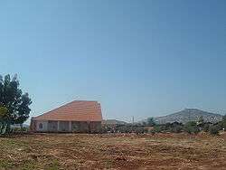 Kalanit synagogue | |
 Kalanit | |
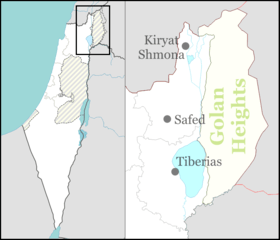
| Coordinates: 32°52′26.21″N 35°27′18.33″E / 32.8739472°N 35.4550917°ECoordinates: 32°52′26.21″N 35°27′18.33″E / 32.8739472°N 35.4550917°E | |
| District | Northern |
| Council | Merom HaGalil |
| Affiliation | Hapoel HaMizrachi |
| Founded | 1982 |
| Population (2017)[1] | 220 |
Kalanit (Hebrew: כַּלָּנִית) is a community settlement in northern Israel. Located between Tiberias and Karmiel, next to Maghar, it falls under the jurisdiction of Merom HaGalil Regional Council. In 2017 it had a population of 220.[1]
History
Kalanit was established in 1981 on the land of the depopulated Palestinian village of Al-Mansura, southeast of the village site.[2]
The village was established as a moshav by the Hapoel HaMizrachi organization with the goal that it would be populated by the children of the families living in the area, and so with time the moshav became a community settlement.
References
- 1 2 "List of localities, in Alphabetical order" (PDF). Israel Central Bureau of Statistics. Retrieved August 26, 2018.
- ↑ Khalidi, W. (1992). All That Remains: The Palestinian Villages Occupied and Depopulated by Israel in 1948. Washington D.C.: Institute for Palestine Studies. p. 533. ISBN 0-88728-224-5.
This article is issued from
Wikipedia.
The text is licensed under Creative Commons - Attribution - Sharealike.
Additional terms may apply for the media files.