Kadita
| Kadita כדיתה / קדיתא | |
|---|---|
 | |
 Kadita | |
| Coordinates: 33°00′18″N 35°27′50″E / 33.00500°N 35.46389°ECoordinates: 33°00′18″N 35°27′50″E / 33.00500°N 35.46389°E | |
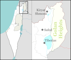
| District | Northern |
| Council | Merom HaGalil |
| Affiliation | Agricultural Union |
| Founded | 1991 |
| Population (2017)[1] | 180 |
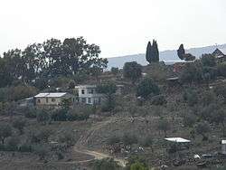
Kadita (Hebrew: כדיתה or קדיתא) is an unrecognised community settlement in northern Israel. Located in the central Galilee, it falls under the jurisdiction of Merom HaGalil Regional Council. In 2017 it had a population of 180.[1]
History
In 1988 four families received land from the Israel Land Administration in return for giving up their land on Mount Meron.[2] The site had previously been the Palestinian village of Qaddita, whose residents fled during the 1948 Arab–Israeli War.[3] Rabbi Tarfon was buried in the area.[3]
In 1991 an association was formed to build an ecovillage at the site, and received the support of Housing Minister Ariel Sharon. Twenty families settled on the land and temporary homes were built. Another 14 families arrived in 2000.[3] However, the Israel Land Administration viewed the residents as squatters, issued evacuation orders and demolished temporary buildings on several occasions.[3]
References
| Wikimedia Commons has media related to Kadita. |
- 1 2 "List of localities, in Alphabetical order" (PDF). Israel Central Bureau of Statistics. Retrieved August 26, 2018.
- ↑ Evacuation of the "Kadita" invasion near Safed Israel Land Administration
- 1 2 3 4 False Promises of Paradise Haaretz, 6 May 2008