Kalam Valley
| Kalam | |
|---|---|
| Valley | |
| کالام | |
.jpg) Kalam Valley | |
| Country |
|
| Province | Khyber Pakhtunkhwa |
| District | Swat |
| Elevation | 2,001 m (6,565 ft) |
| Time zone | UTC+5 (PST) |
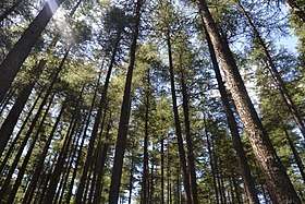
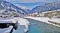
Kalam (Kalami, Pashto, & Urdu: کالام) is a valley located at distance of 99 kilometres (62 mi) from Mingora in the northern upper reaches of Swat valley along the bank of Swat River in Khyber Pakhtunkhwa province of Pakistan.[1][2] Kalam is surrounded by lush green hills, thick forests and bestowed with mesmeric lakes, meadows and waterfalls which are worth seen features of the landscape. It is the birthplace of Swat river which forms with confluence of two major tributaries of Gabral river and Ushu river.[3]
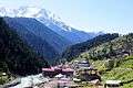
It is a spacious sub-valley of Swat, at an elevation of about 2,000 meters (6,600 feet) above sea level, and providing rooms for a small but fertile plateau above the river for farming.[4] Here, the metaled road ends and shingle road leads to the Usho and Utror valleys. From Matiltan some snow-capped mountains are visible including Mount Falaksar 5,918 meters (19,416 feet), and another unnamed peak 6,096 meters (20,000 feet) high.[5]
There are grand hotels in Kalam for tourists to rest and enjoy the cool breeze of Swat river.[6]
Climate
With a mild and generally warm and temperate climate, Kalam features a humid subtropical climate (Cfa) under the Köppen climate classification. The average temperature in Kalam is 13.4 °C, while the annual precipitation averages 639 mm. Even in the driest months, there is a lot of precipitation. November is the driest month with 15 mm of precipitation, while April, the wettest month, has an average precipitation of 93 mm.
July is the hottest month of the year with an average temperature of 24.1 °C. The coldest month January has an average temperature of 1.5 °C.
| Climate data for Kalam | |||||||||||||
|---|---|---|---|---|---|---|---|---|---|---|---|---|---|
| Month | Jan | Feb | Mar | Apr | May | Jun | Jul | Aug | Sep | Oct | Nov | Dec | Year |
| Average high °C (°F) | 5.3 (41.5) |
6.9 (44.4) |
12.3 (54.1) |
18.2 (64.8) |
23.1 (73.6) |
29.5 (85.1) |
30.5 (86.9) |
29.4 (84.9) |
26.0 (78.8) |
21.2 (70.2) |
15.0 (59) |
8.1 (46.6) |
18.8 (65.8) |
| Daily mean °C (°F) | 1.5 (34.7) |
2.8 (37) |
7.6 (45.7) |
13.0 (55.4) |
17.3 (63.1) |
23.0 (73.4) |
24.1 (75.4) |
23.4 (74.1) |
19.8 (67.6) |
15.1 (59.2) |
9.5 (49.1) |
4.0 (39.2) |
13.4 (56.2) |
| Average low °C (°F) | −2.2 (28) |
−1.3 (29.7) |
3.0 (37.4) |
7.9 (46.2) |
11.6 (52.9) |
16.6 (61.9) |
17.8 (64) |
17.5 (63.5) |
13.7 (56.7) |
9.0 (48.2) |
4.1 (39.4) |
0.0 (32) |
8.1 (46.7) |
| Source: Climate-Data.org[7] | |||||||||||||
Tourist Spots
Usho (also spelled Ushu) is a hill station in the north east of Kalam valley. It is situated at a distance of 8 kilometers (5.0 mi) from Kalam and 123 kilometers (76 mi) km from Saidu Sharif at the height of 2,300 metres (7,550 feet). It is accessible through a non metalled road from Kalam by jeeps only.
Matiltan
Matiltan is a picturesque spot comes after Usho and located at about 11 km away from Kalam. It is famous for huge glaciers, thick forests and lofty moauntain peaks. The tallest peak of Falaksair mountain can be seen from here clearly.
Utror
Utror hill station is another scenic place in Kalam valley which is located 16 km away from Kalam. It is one of the beautiful valley in the region, surrounded by snow clad mountains and beautiful Kundol lake of the area is worth seen.
Gabral
Gabral is a charming hill station, comes at a distance of 20 km away from Kalam. It is famous for brown swati trout fish, thick lush green forests, medicinal springs, lofty snow clad peaks and beautiful lakes, among them Shahi Bagh lake located to north west of Sazgul region at about three hours of trekking is worth seen.
Lakes
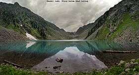
Kalam has large number of alpine glacial lakes, among them Mahodand lake and Kundol lake are very popular due to ease of accessibility. But others like Izmis lake, which is located in close proximity with Kundol lake is one of the spectacular one in the region. Most of these lakes are accessible through tedious trekking over lush green trails across the way.
Mahodand Lake is one of the largest & scenic lake in the Swat valley, located at a distance of about 40 km from Kalam, in the Usho Sub-valley of Kalam which is laid out in the foothills of Hindu Kush mountains. It is accessible with a four-wheel drive vehicle, and is a good resort for fishing, boating and camping. It is surrounded by snow clad mountains, lush green meadows and thick forests which hypontise one to its center.
Kundol Lake is another charming lake in Kalam valley which is located in the north of Utror region at a distance of 19 km away from kalam. It also lies in the foothills of Hindu Kush mountains and accessible via the mesmeric valley of Ladu through a trek of 4–6 hours.[8]
Gallery
See also
References
- ↑ "Kalam Valley in Swat District, Khyber Pakhtunkhwa and Distance from Mingora". Pakistantravelguide.pk. Retrieved 22 July 2018.
- ↑ "Kalam Valley, Swat District, Khyber Pakhtunkhwa". www.worldfortravel.com. Retrieved 22 July 2018.
- ↑ "Birthplace of Swat and Surrounded by Green Hills and Thick Forest". Destinations.com.pk. Retrieved 22 July 2018.
- ↑ Tourists Guide >> Places to Visit >> Kalam Publisher: swat valley.com, Retrieved on 29 September 2012
- ↑ https://www.youtube.com/watch?v=bN3rlHoknRg
- ↑ http://tribune.com.pk/story/27716/all-is-not-lost-for-kalam-valley’s-hosts/
- ↑ "Climate: Kalam - Climate-Data.org". Retrieved 15 September 2016.
- ↑ https://www.youtube.com/watch?v=FrWv06vY9gc
| Wikimedia Commons has media related to Kalam Valley. |
Coordinates: 35°28′48″N 72°35′15″E / 35.4801°N 72.5874°E