Mingora
| Mingora مینگورہ | |
|---|---|
| City | |
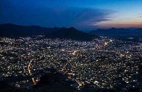
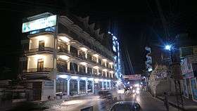
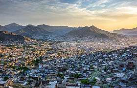 View of Mingora | |
 Mingora  Mingora  Mingora .svg.png) Mingora | |
| Coordinates: 34°46′18″N 72°21′36″E / 34.77167°N 72.36000°ECoordinates: 34°46′18″N 72°21′36″E / 34.77167°N 72.36000°E | |
| Country |
|
| Province |
|
| District | Swat District |
| Tehsil | Babuzai |
| Elevation | 984 m (3,228 ft) |
| Population (2017)[1] | |
| • Total | 331,091 |
| Time zone | UTC+5 (PST) |
| Website | Mingora |
Mingora (Pashto: مینګورہ, Mīngawara; Urdu: مینگورہ) is a commercial city in the Swat District of Khyber Pakhtunkhwa, Pakistan, located at an altitude of 984 metres (3,228 ft), 2 km (1.2 mi) away from the town of Saidu Sharif. Mingora is the third-largest city in Khyber Pakhtunkhwa after Peshawar and Mardan, and the largest in the Swat Valley, as well as the largest city in Malakand Division and in the northern part of Khyber Pakhtunkhwa. Mingora is a major tourist destination, with a large number of hotels.
Climate
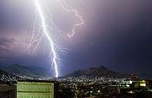
With a mild and generally warm and temperate climate, Mingora features a humid subtropical climate (Cfa) under the Köppen climate classification. The average annual temperature in Mingora is 19.3 °C, while the annual precipitation averages 897 mm. Even in the driest months, there is a lot of precipitation. November is the driest month with 22 mm of precipitation, while August, the wettest month, has an average precipitation of 134 mm.
June is the hottest month of the year with an average temperature of 29.2 °C. The coldest month January has an average temperature of 7.6 °C.
| Climate data for Mingora | |||||||||||||
|---|---|---|---|---|---|---|---|---|---|---|---|---|---|
| Month | Jan | Feb | Mar | Apr | May | Jun | Jul | Aug | Sep | Oct | Nov | Dec | Year |
| Average high °C (°F) | 13.0 (55.4) |
15.8 (60.4) |
20.2 (68.4) |
25.6 (78.1) |
31.7 (89.1) |
36.8 (98.2) |
35.4 (95.7) |
33.7 (92.7) |
32.3 (90.1) |
28.0 (82.4) |
21.8 (71.2) |
15.3 (59.5) |
25.8 (78.4) |
| Daily mean °C (°F) | 7.6 (45.7) |
10.3 (50.5) |
14.2 (57.6) |
19.2 (66.6) |
24.5 (76.1) |
29.2 (84.6) |
29.0 (84.2) |
27.8 (82) |
25.6 (78.1) |
20.5 (68.9) |
14.6 (58.3) |
9.4 (48.9) |
19.3 (66.8) |
| Average low °C (°F) | 2.1 (35.8) |
4.8 (40.6) |
8.2 (46.8) |
12.7 (54.9) |
17.3 (63.1) |
21.6 (70.9) |
22.6 (72.7) |
21.9 (71.4) |
18.9 (66) |
12.9 (55.2) |
7.4 (45.3) |
3.5 (38.3) |
12.8 (55.1) |
| Average rainfall mm (inches) | 81 (3.19) |
98 (3.86) |
125 (4.92) |
90 (3.54) |
46 (1.81) |
31 (1.22) |
130 (5.12) |
134 (5.28) |
64 (2.52) |
28 (1.1) |
22 (0.87) |
48 (1.89) |
897 (35.32) |
| Source: Climate-Data.org[2] | |||||||||||||
History
Many Buddhist remains and carvings have been discovered near Mingora in the Jambil River Valley. At Panr, a stupa and monastery dated to the 1st century CE has been excavated. At Loe Banr, Butkara II and Matalai, Italian archaeologists unearthed 475 Aryan graves dated between 1520 and 170 BC and two horse skeletons.[3] On the opposite side of the River Swat at Aligrama, near the Saidu Sharif airport, a site of Gandhara grave culture was discovered by Italian archaeologists and dated to 1000 BC.
Notable people from Mingora
- Malala Yousafzai, Pakistani activist for female education and the first Pashtun Nobel laureate
- Nazia Iqbal, Pashto singer
- Ghazala Javed (1988-2012), Pashto singer
- Nasir-ul-Mulk, former Pakistani Chief Justice
See also
References
- ↑ "POPULATION AND HOUSEHOLD DETAIL FROM BLOCK TO DISTRICT LEVEL: KHYBER PAKHTUNKHWA (SWAT DISTRICT)" (PDF). Pakistan Bureau of Statistics. 2018-01-03. Retrieved 2018-04-24.
- ↑ "Climate: Mingora - Climate-Data.org". Retrieved 15 September 2016.
- ↑ Augusto Azzaroli, Two Proto-historic Horse Skeletons from Swāt, Pakistan, East and West, Vol. 25, No. 3/4 (September-December 1975), pp. 353-357: