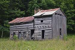
John Shell Cabin
|
Shell, John, Cabin | |
 | |
  | |
| Nearest city | Chappell, Kentucky |
|---|---|
| Coordinates | 36°58′42″N 83°19′36″W / 36.97833°N 83.32667°WCoordinates: 36°58′42″N 83°19′36″W / 36.97833°N 83.32667°W |
| Area | 1 acre (0.40 ha) |
| Built | c.1850 |
| NRHP reference # | 75000791[1] |
| Added to NRHP | November 12, 1975 |
The John Shell Cabin, in Leslie County, Kentucky, located south of Chappell, Kentucky on Greasy Creek Road (Kentucky Route 2009), was listed on the National Register of Historic Places in 1975.[1]
It dates from c.1850. The listing included four contributing buildings.[1]
It is on the side of Gray Mountain, just north of the Leslie-Harlan county line. It is located on the Shell Branch of the Laurel Fork of Greasy Creek. It is located about 15 miles approximately southeast of U.S. Highway 421.[2]
It was home of rifle-maker John Shell.[2]
References
- 1 2 3 National Park Service (2010-07-09). "National Register Information System". National Register of Historic Places. National Park Service.
- 1 2 Gloria Mills (September 1975). "National Register of Historic Places Inventory/Nomination: John Shell Cabin". National Park Service. Retrieved April 1, 2018. With seven photos from 1975.
| Topics | |
|---|---|
| Lists by states |
|
| Lists by insular areas | |
| Lists by associated states | |
| Other areas | |
| |
This article is issued from
Wikipedia.
The text is licensed under Creative Commons - Attribution - Sharealike.
Additional terms may apply for the media files.