Jerusalem Road 16
| Jerusalem Road 16 | |
|---|---|
| כביש 16 ירושלים המתוכנן | |
 | |
| Route information | |
| Length | 4.7 km (2.9 mi) |
| Major junctions | |
| west end | Motza Interchange |
| east end | Givat Mordechai |
| Highway system | |
| Highways | |
Site of Nahal Revida Interchange
Jerusalem Road 16 is a planned road to alleviate the traffic congestion at the Ben Gurion Boulevard/Jaffa Road western entrance to Jerusalem and provide direct access to the south and central sections of the city from the west. The project will cost approximately NIS 1.5 billion and is expected to be completed by the end of 2023.[1][2][3][4][5]
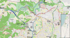
Route
The planned road would connect Highway 1 at the new Motza Interchange and Jerusalem's Highway 50 (Begin Boulevard) at Givat Mordechai Interchange. The road would travel mostly through a series of tunnels under the west Jerusalem neighborhhods of Har Nof and Yefeh Nof and the parking lots of Shaare Zedek Medical Center. In the center, an above ground interchange would be built in the valley of Nahal Revida (Revida Stream) adjacent to the Pi Glilot Fuel Terminal to connect to Derech Yosef Weitz leading to Givat Shaul. The road would be constructed as a four lane freeway with a speed limit of 80 km/h.
History
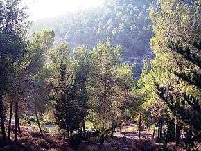
The road was first proposed in the 1990s. Originally, the road was supposed to skirt around the western and southern slopes of Har Nof before entering a tunnel at Nahal Revida continuing eastward under Yefeh Nof. This would have created nearly a kilometer of fully open road through the Jerusalem Forest. This plan was met with stiff opposition by the Jewish National Fund and a variety of "Green" groups due to ecological damage to the forest. As a result, the plan was changed to include a tunnel under Har Nof with an intermediate above-ground interchange at Nahal Revida.[6]
The program was stopped in 2003 to conduct environmental studies and consider an alternative to the Nahal Revida Interchange. By the end of 2007, the National Infrastructure Committee decided to adopt the plan pending clarifications and public review. In 2010, the plan again moved forward with an indemnity agreement between the Jerusalem Municipality and the Israel Ministry of Transport. At the same time, responsibility for building the road was shifted from the Moriah Jerusalem Development Corporation to the National Roads Company of Israel. Economic and environmental studies were updated. A plan to build the road as one long tunnel with Nahal Ravida Interchange underground was rejected both for economic reasons and because of the need for massive ventilation facilities that would cause greater environmental damage to the forest.[6]
The plan was approved in 2011, again with further delays pending public review.[7] At the end of 2012, according to the National Roads Company, the plan has been approved and budgeted. After many delays, the contract for construction was finally awarded in August 2018, with construction expected to begin in 2019 and last through 2023.[5]
Following the death of Talmudic scholar and former Sephardi Chief Rabbi of Israel Ovadia Yosef in 2013, Israeli Minister of Transport Yisrael Katz announced that the road would be named in his honor.[8] However, the Jerusalem Municipality Names Committee which has jurisdiction in the matter declared in 2017 that the road would be named in honor of former Israeli Prime Minister, Ariel Sharon.[9]
Planned Interchanges (west to east)
| km | Name | Type | Meaning | Location | Road(s) Crossed |
|---|---|---|---|---|---|
| Planned (Completion: 2023) | |||||
| 0 | מחלף מוצא (Motza Interchange) |
Origin | Motza, Beit Zayit |
||
| 1.2 | Tunnels 4 lanes, 1.5 km |
under Har Nof | |||
| 2.8 | מחלף נחל רבידה (Nahal Revida Interchange) |
Revida Stream | Givat Shaul | Derech Yosef Weitz. | |
| 2.9 | Tunnels 4 lanes, 1.3 km |
under Yefeh Nof & parking lots of Shaare Zedek Medical Center |
|||
| 4.2 | מחלף בייט (Beyth Interchange) |
named after Hans (Shmuel) Beyth |
Ramat Beit HaKerem, Bayit Vegan |
Shmuel Beyth St. | |
| 4.7 | מחלף גבעת מרדכי (Givat Mordechai Interchange) |
Mordechai's Hill | Givat Mordechai | (Begin Boulevard), Bezalel Bazak St. | |
References
- ↑ "Road 16, New entrance to Jerusalem, between Motza and Begin Highway". Israel Ministry of Transport, National Infrastructure & Road Safety. Retrieved 2012-12-02. (in Hebrew)
- ↑ "Road 16, Between the Motaz Curve and Begin Highway in Jerusalem". National Roads Company of Israel. Retrieved 2012-12-02. (in Hebrew)
- ↑ "Roads Planned and Under Construstion". Jerusalem Transport Master Plan Committee. Retrieved 2011-08-23. (in Hebrew)
- ↑ "Jerusalem Transportation Network-map". Jerusalem Transport Master Plan Committee. Archived from the original on 2012-12-18. Retrieved 2011-08-23. (in Hebrew)
- 1 2 https://www.kolhair.co.il/jerusalem-news/66785/
- 1 2 "Save the Jerusalem Forest: Road 16". Forum of Organizations for the Jerusalem Forest. Archived from the original on 2011-08-09 9. Retrieved 2012-12-02. Check date values in:
|archivedate=(help) - ↑ Sharon Udasin (2011-07-12). "Ministry okays paving road, cutting J'lem-TA travel time". Jerusalem Post. Retrieved 2013-07-22.
- ↑ Gil Ronen (2011-10-13). "New Jerusalem Road to be Named after Rabbi Ovadia". Arutz Sheva. Retrieved 2013-10-14.
- ↑ Meirav Arad (2017-12-28). "The new entrance road to Jerusalem will be named after Ariel Sharon". Arutz Sheva. Retrieved 2018-06-15.
External links
- Road 16 Position and Elevation Diagrams PDF on National Roads Company of Israel website (in Hebrew)
- Road 16 Environmental impact statement PDF on National Roads Company of Israel website (in Hebrew)
- Plan documents for National Infrastructure Plan 2 (Road 16)
Coordinates: 31°46′44″N 35°10′51″E / 31.77889°N 35.18083°E
| Roads |
| ||||
|---|---|---|---|---|---|
| Bus operators | |||||
| Rail transport |
| ||||
| Sea ports | |||||
| Aviation |
| ||||
| Cable cars | |||||
| By city | |||||
| Smart cards | |||||