Sunda Trench
The Sunda Trench, earlier known as and sometimes still indicated as the Java Trench,[1] is an oceanic trench located in the Indian Ocean near Sumatra, formed where the Australian-Capricorn plates subduct under a part of the Eurasian Plate. It is 3,200 kilometres (2,000 mi) long.[2] Its maximum depth 7,725 metres (25,344 ft)[3] (at 10°19'S, 109°58'E, about 320 km south of Yogyakarta), is the deepest point in the Indian Ocean. The trench stretches from the Lesser Sunda Islands past Java, around the southern coast of Sumatra on to the Andaman Islands, and forms the boundary between Indo-Australian Plate and Eurasian plate (more specifically, Sunda Plate). The trench is considered to be part of the Pacific Ring of Fire as well as one of a ring of oceanic trenches around the northern edges of the Australian Plate.
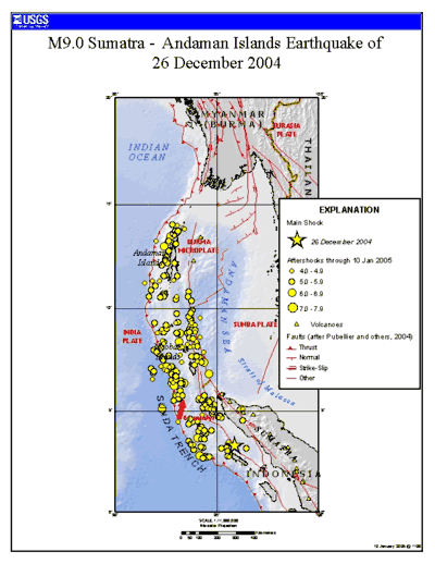
In 2005, scientists found evidence that the 2004 earthquake activity in the area of the Java Trench could lead to further catastrophic shifting within a relatively short period of time, perhaps less than a decade.[4] This threat has resulted in international agreements to establish a tsunami warning system in place along the Indian Ocean coast.[5]
Characteristics
For about half its length, off of Sumatra, it is divided into two parallel troughs by an underwater ridge, and much of the trench is at least partially filled with sediments. Mappings after the 2004 Indian Ocean earthquake of the plate boundary showed resemblance to suspension bridge cables, with peaks and sags, indicative of asperity and locked faults, instead of the traditional wedge shape expected.[6]
Exploration
Some of the earliest exploration of the Trench occurred in the late 1950s when Robert Fisher, Research Geologist at the Scripps Institution of Oceanography, investigated the trench as part of a worldwide scientific field exploration of the world's ocean floor and sub-oceanic crustal-structure. Bomb-sounding, echo-train analysis and manometer were some of the techniques used to determine the depth of the trench. The research contributed to an understanding of the subduction characteristic of the Pacific margins.[7] Various agencies have explored the trench in the aftermath of the 2004 earthquake, and these explorations have revealed extensive changes in the ocean floor.[8]
Associated seismicity
The subduction of the Indo-Australian Plate beneath a bloc of the Eurasian Plate is associated with numerous earthquakes. Several of these earthquakes are notable for their size, associated tsunamis, and/or the number of fatalities they caused.
Sumatra segment
- 1797 Sumatra earthquake: magnitude ~8.4
- 1833 Sumatra earthquake: magnitude 8.8–9.2
- 1861 Sumatra earthquake: magnitude ~8.5
- 1935 Sumatra earthquake: magnitude 7.7
- 2000 Sumatra earthquake: magnitude 7.9
- 2002 Sumatra earthquake: A magnitude 7.3 earthquake that occurred at the boundary between the rupture areas of the 2004 and 2005 earthquakes listed below.
- 2004 Indian Ocean earthquake and tsunami: Mw 9.1–9.3
- 2005 Nias–Simeulue earthquake: magnitude 8.6
- September 2007 Sumatra earthquakes: Series of earthquakes, the three largest were magnitude 8.5, 7.9 and 7.0.
- 2009 Sumatra earthquakes: magnitude 7.9
- 2010 Mentawai earthquake and tsunami: magnitude 7.7
Java segment
- 1917 Bali earthquake: magnitude 6.6
- 1994 Java earthquake: magnitude 7.8
- 2006 Pangandaran earthquake and tsunami: magnitude 7.7
- 2009 West Java earthquake: magnitude 7.0
See also
References
- ↑ Sunda Trench (4°30' S 11°10' S 100°00' E 119°00' Accredited by: SCGN (Apr. 1987) The trench was studied in some detail in 1920's-1930's by Dutch geodesist F.A. Vening Meinesz, who made classic pendulum gravity measurements in a Dutch submarine. Shown as Java Trench in ACUF (Advisory Committee on Undersea Features Gazetteer). see also: http://www.gebco.net/
- ↑ Java Trench – article from Encyclopædia Britannica
- ↑ Nazri, M.; Halif, A. (2005). "The physics of tsunami: basic understanding of the Indian Ocean disaster" (PDF). American Journal of Applied Sciences. 2 (8): 1187–1192. Retrieved 26 December 2017.
- ↑ Asia primed for next big quake – earth – 19 March 2005 – New Scientist Environment
- ↑ IOC: Towards a Tsunami Warning System in the Indian Ocean Archived 1 February 2006 at Archive.is
- ↑ "Press Release: Folded sediment unusual in Sumatran tsunami area". Penn State University. February 2, 2007.
- ↑ https://web.archive.org/web/20060430125347/http://www.ngdc.noaa.gov/mgg/gebco/news/rlfnews.pdf
- ↑ "The underwater survey of the SUMATRA earthquake source area"
Further reading
- Špičák, A., V. Hanuš, and J. Vaněk (2007), Earthquake occurrence along the Java trench in front of the onset of the Wadati–Benioff zone: Beginning of a new subduction cycle?, Tectonics, 26, TC1005