Jackson Township, Parke County, Indiana
| Jackson Township | |
|---|---|
| Township | |
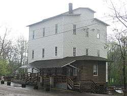 The historic roller mill in Mansfield | |
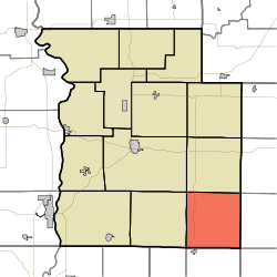 Location in Parke County | |
| Coordinates: 39°38′57″N 87°03′39″W / 39.64917°N 87.06083°WCoordinates: 39°38′57″N 87°03′39″W / 39.64917°N 87.06083°W | |
| Country |
|
| State |
|
| County | Parke |
| Government | |
| • Type | Indiana township |
| Area | |
| • Total | 35.76 sq mi (92.6 km2) |
| • Land | 35.57 sq mi (92.1 km2) |
| • Water | 0.19 sq mi (0.5 km2) 0.53% |
| Elevation[1] | 614 ft (187 m) |
| Population (2010) | |
| • Total | 737 |
| • Density | 20.7/sq mi (8.0/km2) |
| Time zone | UTC-5 (Eastern (EST)) |
| • Summer (DST) | UTC-4 (EDT) |
| ZIP codes | 46135, 47834, 47837, 47872 |
| Area code(s) | 765 |
| GNIS feature ID | 453460 |
Jackson Township is one of thirteen townships in Parke County, Indiana, United States. As of the 2010 census, its population was 737 and it contained 475 housing units.[2]
History
Jackson Township was named for Andrew Jackson, 7th President of the United States.[3]
The Big Rocky Fork Covered Bridge, Mansfield Covered Bridge, and Mansfield Roller Mill are listed on the National Register of Historic Places.[4]
Geography
According to the 2010 census, the township has a total area of 35.76 square miles (92.6 km2), of which 35.57 square miles (92.1 km2) (or 99.47%) is land and 0.19 square miles (0.49 km2) (or 0.53%) is water.[2]
Unincorporated towns
- Alma Lake at 39°36′30″N 87°01′10″W / 39.608377°N 87.019457°W
- Lena at 39°36′18″N 87°06′26″W / 39.6050417°N 87.1072365°W
- Mansfield at 39°40′35″N 87°06′08″W / 39.676431°N 87.102236°W
(This list is based on USGS data and may include former settlements.)
Cemeteries
The township contains these two cemeteries: Jacks and Moore.
Major highways
Lakes
- Alma Lake
- Rocky Fork Lake
School districts
- Clay Community Schools
Political districts
- State House District 44
- State Senate District 38
References
- "Jackson Township, Parke County, Indiana". Geographic Names Information System. United States Geological Survey. Retrieved 2009-11-01.
- United States Census Bureau 2009 TIGER/Line Shapefiles
- IndianaMap
- ↑ "US Board on Geographic Names". United States Geological Survey. October 25, 2007. Retrieved 2017-05-09.
- 1 2 "Population, Housing Units, Area, and Density: 2010 - County -- County Subdivision and Place -- 2010 Census Summary File 1". United States Census. Retrieved 2013-05-10.
- ↑ History of Parke and Vermillion Counties, Indiana. B.F. Bowen & Cos. 1913. p. 187.
- ↑ National Park Service (2010-07-09). "National Register Information System". National Register of Historic Places. National Park Service.
External links
- Indiana Township Association
- United Township Association of Indiana
- City-Data.com page for Jackson Township
Places adjacent to Jackson Township, Parke County, Indiana | |
|---|---|
Municipalities and communities of Parke County, Indiana, United States | ||
|---|---|---|
| Towns | ||
| Townships | ||
| Unincorporated communities |
| |
| Ghost town | ||
| Footnotes | ‡This populated place also has portions in an adjacent county or counties | |
This article is issued from
Wikipedia.
The text is licensed under Creative Commons - Attribution - Sharealike.
Additional terms may apply for the media files.