Penn Township, Parke County, Indiana
| Penn Township | |
|---|---|
| Township | |
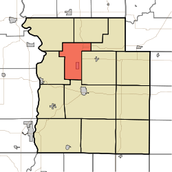 Location in Parke County | |
| Coordinates: 39°51′09″N 87°15′30″W / 39.85250°N 87.25833°WCoordinates: 39°51′09″N 87°15′30″W / 39.85250°N 87.25833°W | |
| Country |
|
| State |
|
| County | Parke |
| Government | |
| • Type | Indiana township |
| Area | |
| • Total | 23.78 sq mi (61.6 km2) |
| • Land | 23.73 sq mi (61.5 km2) |
| • Water | 0.05 sq mi (0.1 km2) 0.21% |
| Elevation[1] | 633 ft (193 m) |
| Population (2010) | |
| • Total | 810 |
| • Density | 34.1/sq mi (13.2/km2) |
| Time zone | UTC-5 (Eastern (EST)) |
| • Summer (DST) | UTC-4 (EDT) |
| ZIP codes | 47832, 47859, 47862, 47872, 47952 |
| Area code(s) | 765 |
| GNIS feature ID | 453713 |
Penn Township is one of thirteen townships in Parke County, Indiana, United States. As of the 2010 census, its population was 810 and it contained 368 housing units.[2]
History
Penn Township was organized in 1854, and was originally built up chiefly by Quakers.[3]
The Cox Ford Covered Bridge, Joseph Finney House, and Jackson Covered Bridge are listed on the National Register of Historic Places.[4]
Geography
According to the 2010 census, the township has a total area of 23.78 square miles (61.6 km2), of which 23.73 square miles (61.5 km2) (or 99.79%) is land and 0.05 square miles (0.13 km2) (or 0.21%) is water.[2] The township includes the southwest quarter of Turkey Run State Park.
Cities, towns, villages
Unincorporated towns
- Annapolis at 39°51′09″N 87°15′02″W / 39.852540°N 87.250569°W
- Coke Oven Hollow at 39°51′11″N 87°17′31″W / 39.853095°N 87.291958°W
- Rockport at 39°52′51″N 87°16′44″W / 39.880873°N 87.278902°W
- Stumptown at 39°51′08″N 87°16′28″W / 39.852262°N 87.274458°W
(This list is based on USGS data and may include former settlements.)
Extinct towns
- Pottertown at 39°49′51″N 87°15′44″W / 39.830873°N 87.262236°W
(These towns are listed as "historical" by the USGS.)
Cemeteries
The township contains these four cemeteries: Bloomingdale, Coffin, DeBaun and Hethcoe.
Major highways
School districts
- Turkey Run Community School Corporation
Political districts
- State House District 41
- State Senate District 38
References
- "Penn Township, Parke County, Indiana". Geographic Names Information System. United States Geological Survey. Retrieved 2009-11-01.
- United States Census Bureau 2009 TIGER/Line Shapefiles
- IndianaMap
- ↑ "US Board on Geographic Names". United States Geological Survey. October 25, 2007. Retrieved 2017-05-09.
- 1 2 "Population, Housing Units, Area, and Density: 2010 - County -- County Subdivision and Place -- 2010 Census Summary File 1". United States Census. Retrieved 2013-05-10.
- ↑ History of Parke and Vermillion Counties, Indiana. B.F. Bowen & Cos. 1913. p. 195.
- ↑ National Park Service (2010-07-09). "National Register Information System". National Register of Historic Places. National Park Service.
External links
- Indiana Township Association
- United Township Association of Indiana
- City-Data.com page for Penn Township
Places adjacent to Penn Township, Parke County, Indiana | |
|---|---|
Municipalities and communities of Parke County, Indiana, United States | ||
|---|---|---|
| Towns | ||
| Townships | ||
| Unincorporated communities |
| |
| Ghost town | ||
| Footnotes | ‡This populated place also has portions in an adjacent county or counties | |