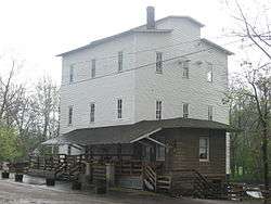
Mansfield Roller Mill
|
Mansfield Roller Mill | |
 | |
   | |
| Location | Mansfield, Indiana |
|---|---|
| Coordinates | 39°40′36.75″N 87°6′6.03″W / 39.6768750°N 87.1016750°WCoordinates: 39°40′36.75″N 87°6′6.03″W / 39.6768750°N 87.1016750°W |
| Architect | Jacob Rohm |
| MPS | Grain Mills in Indiana MPS |
| NRHP reference # | 90001788 [1] |
| Added to NRHP | December 7, 1990 |
The Mansfield Roller Mill or Mansfield Mill is a (gristmill) that was built in Mansfield, Indiana, United States by James Kelsey and Francis Dickson in 1820; it has always run on water power from Big Racoon Creek. The original mill was a 30-foot (9.1 m) by 30-foot (9.1 m) log building.
According to legend, glacial stones from a nearby farm were used for grinding. In the mid-19th century a sash saw mill and a carding mill were added to the grist mill. The mill is a state historic site owned by the Indiana Department of Natural Resources, Division of State Parks. It is operated by the Raccoon Lake Interpretive Services from nearby Raccoon State Recreation Area. The Mansfield Roller Mill has always run off of water powered turbines. The Rodney Hunt turbine that currently powers the Mill was installed in 1886.
History
Between 1973 and 1978 Tex Kelly (Edward Earl Terry (actor)) "The Bad Man of the movies" purchased the Mansfield Roller Mill and several other buildings and attempt to fulfill his dream of turning the town into Frontier City. His efforts failed and in 1979, Tex and Isabel returned to Tex's hometown of Coxville, Indiana and opened "Tex's Longhorn Tavern".[2][3]
Owners Jack & Shirley Dalton and Frank & Sharon Hutcheson donated the mill to the Indiana Department of Natural Resources, Division of State Museums and Historic Sites in 1995. In 2002 the mill was traded from The Division of Historic Sites to the Division of State Parks and Reservoirs, and is now owned, maintained and operated by Raccoon State Recreation Area.
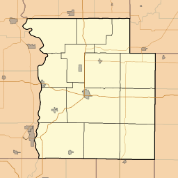
The Mansfield Roller Mill is located at the corner of Mansfield Rd. (historic) and Big Raccoon Creek in Mansfield IN 47872, just southeast of Rockville, Indiana.
Mansfield Road (historic) is now called by several names depending on the map date:
- Country Road-37 (CR-37) (Most maps)
- Green Castle Road
- East 700 South
Geographic Coordinates
- Latitude: 39° 40' 35" N Longitude: 87° 6' 7.99" W
- Google Map
See also
External links
- Historic Mansfield Roller Mill - official site
- Mansfield Village
- Historic Roller Mill
References
- ↑ National Park Service (2007-01-23). "National Register Information System". National Register of Historic Places. National Park Service.
- ↑ Parke County - Covered Bridge Capital of the World Archived 2007-05-22 at the Wayback Machine.
- ↑ Tex Terry