Izium
| Izium Ізюм | |||
|---|---|---|---|
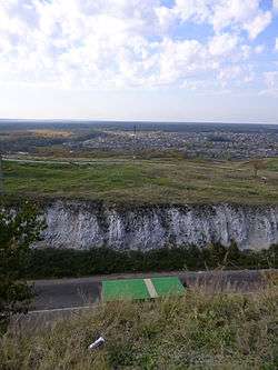 Izyum city view from Kremenets Mountain | |||
| |||
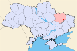 Map of Ukraine with Izyum highlighted. | |||
 Izium Location of Izium | |||
| Coordinates: 49°12′46″N 37°15′25″E / 49.21278°N 37.25694°E | |||
| Country Oblast Raion |
Ukraine Kharkiv Oblast | ||
| founded | 1681 | ||
| city | 1765[1] | ||
| Government | |||
| • Mayor | Valeriy Marchenko (New Faces)[2] | ||
| Area | |||
| • Total | 43.6 km2 (16.8 sq mi) | ||
| Population (2017) | |||
| • Total | 48 966[3] | ||
| Postal code | 64300 | ||
| Area code(s) | 380-5743 | ||
| Licence plate, ХА, ХК | АХ | ||
| Sister cities | Krasnogorsk, Moscow Oblast | ||
| Website | Izium city official site | ||

Izium (Ukrainian: Ізюм; also Romanized Izum, Izyum; literally raisins), is a city situated on the Donets River in Kharkiv Oblast (province) of eastern Ukraine. Serving as the administrative center of Izium Raion (district), Izium is administratively incorporated as a city of oblast significance and does not belong to the raion. It is located approximately 75 miles (120 km) southeast of the oblast capital, Kharkiv. Population: 49,370 (2017 est.)[4]
History
First mentioned in 1571 in connection with the Izium Warpath of the Crimean Tatars.[5]
In 1639 was mentioned as small outpost.[5]
In 1681 Russian fortress was built here,[6][7] in 1684 - the five-domed Baroque cathedral of the Saviour's Transfiguration (The cathedral was renovated in 1902 and restored in 1955).
Later, Izyum was a significant centre of the Sloboda Ukraine and home to a regiment of Cossacks between 1688 and 1765.
In 1765 Izyum became a city.
In 1780 Izyum became an uyezd city.
The churches of Ascension (1819–21) and of St. Nicholas (1809–23) rank among the finest Neoclassical buildings in the region.
World War II
During World War II, the Red Army held a large bridgehead here, allowing for a salient that was cut off by counterattacking German forces (during the Second Battle of Kharkov) and eliminated in one of the most expensive learning errors for the Red Army.[8] Izium was occupied by the German Army from 24 June 1942 to 5 February 1943.
2014 Russian military intervention in Ukraine
The town was the site of sporadic fighting during the 2014–15 Russian military intervention in Ukraine. In April 2014 Russian separatist forces occupied the city of Sloviansk 30 miles south of Izium. An operation by Ukrainian forces to remove these forces bogged down and checkpoints around the Izium were formed to stop possible intrusion into the city. On June 15 a Ukrainian checkpoint outside the city was attacked by Russian forces. On 19 June 2014 Ukrainian forces defeated a large group of Russian separatists at Yampil, approximately 40 miles southwest of Izium, signaling the furthest north the Russian forces would advance. As part of the Siege of Sloviansk and Battle of Kramatorsk both cities were recaptured by Ukrainian forces. Due to its proximity to the front line the city, along with the Kramatorsk Airfield which the Ukrainian military was able to control through the battles, served as a staging area for Ukrainian troops prior to Sloviansk and Kramatorsk being recaptured.[9][10][11][12]
European route E40 passes through Izium, connecting Luhansk-Sloviansk-Kharkiv, three important cities to both pro Russia and Ukrainian forces. Controlling the highway was instrumental as it was the fastest access route into Sloviansk, as well as allowing for possible expansion of separatist territory into Kharkiv region. The Sloviansk-Izium highway was referred to as the "highway of death" by locals during the summer of 2014, however large scale fighting halted once Ukrainian forces captured Sloviansk.[13] Early April 2016 the Security Service of Ukraine arrested an alleged saboteur who was accused of wanting to explode the railway near Izium to aid the separatists.[14]
Decommunization and Westernization
In order to comply with decommunization laws the local ‘Soviet Square' was renamed ‘John Lennon Square' in February 2016.[15]
Geography
Climate
The Köppen Climate Classification subtype for this climate is "Dfb". (Warm Summer Continental Climate).[16]
| Climate data for Izium (1949–2011) | |||||||||||||
|---|---|---|---|---|---|---|---|---|---|---|---|---|---|
| Month | Jan | Feb | Mar | Apr | May | Jun | Jul | Aug | Sep | Oct | Nov | Dec | Year |
| Record high °C (°F) | 13.1 (55.6) |
16.3 (61.3) |
24.0 (75.2) |
31.0 (87.8) |
36.7 (98.1) |
37.4 (99.3) |
39.1 (102.4) |
39.4 (102.9) |
34.4 (93.9) |
31.1 (88) |
22.0 (71.6) |
20.0 (68) |
39.4 (102.9) |
| Average high °C (°F) | −2.2 (28) |
−1.1 (30) |
5.2 (41.4) |
15.1 (59.2) |
22.1 (71.8) |
25.8 (78.4) |
27.9 (82.2) |
27.1 (80.8) |
21.0 (69.8) |
12.9 (55.2) |
5.1 (41.2) |
0.0 (32) |
13.2 (55.8) |
| Daily mean °C (°F) | −5.2 (22.6) |
−4.6 (23.7) |
0.8 (33.4) |
9.4 (48.9) |
15.6 (60.1) |
19.4 (66.9) |
21.3 (70.3) |
19.9 (67.8) |
14.2 (57.6) |
7.5 (45.5) |
1.7 (35.1) |
−2.8 (27) |
8.1 (46.6) |
| Average low °C (°F) | −8.5 (16.7) |
−8.3 (17.1) |
−3.1 (26.4) |
3.8 (38.8) |
8.8 (47.8) |
12.8 (55) |
14.7 (58.5) |
12.9 (55.2) |
7.7 (45.9) |
2.5 (36.5) |
−1.4 (29.5) |
−5.7 (21.7) |
3.0 (37.4) |
| Record low °C (°F) | −35.0 (−31) |
−36.1 (−33) |
−29.7 (−21.5) |
−9.0 (15.8) |
−2.8 (27) |
1.1 (34) |
3.0 (37.4) |
1.1 (34) |
−6.7 (19.9) |
−17.0 (1.4) |
−22.6 (−8.7) |
−33.2 (−27.8) |
−36.1 (−33) |
| Average precipitation mm (inches) | 47.1 (1.854) |
39.0 (1.535) |
41.4 (1.63) |
44.1 (1.736) |
51.8 (2.039) |
75.0 (2.953) |
60.9 (2.398) |
47.6 (1.874) |
50.7 (1.996) |
48.1 (1.894) |
43.1 (1.697) |
52.1 (2.051) |
600.9 (23.657) |
| Average precipitation days | 20.0 | 16.4 | 16.3 | 10.2 | 9.7 | 8.5 | 6.3 | 4.6 | 8.1 | 10.5 | 15.4 | 19.4 | 145.4 |
| Average relative humidity (%) | 84.7 | 81.5 | 76.2 | 65.1 | 64.8 | 66.7 | 67.5 | 64.8 | 72.9 | 80.1 | 84.4 | 85.9 | 74.6 |
| Source: Climatebase.ru[17] | |||||||||||||
Gallery
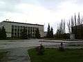 City Hall
 Monument commemorating the battle of Volodymyr Monomakh against Cumans
.JPG) Historical building in Izium
Historical building in Izium Spartak cinema
_2.JPG) Ascension Church
Ascension Church.JPG) Transfiguration Church
Transfiguration Church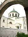 Holy Cross Church
 A holy well in Izium
 Izium railway station
See also
External links
- (in English) / History of the city
- (in English) Encyclopædia Britannica Online
References
- ↑ Изюм // Большой энциклопедический словарь (в 2-х тт.). / редколл., гл. ред. А. М. Прохоров. том 1. М., "Советская энциклопедия", 1991. стр.481
- ↑ http://www.sq.com.ua/rus/news/vlast/30.10.2015/izbrany_mery_vosmi_gorodov_harkovskoj_oblasti_oficialnye_dannye/
- ↑ Чисельність населення (за оцінкою) на 1 травня 2017 року // Головне управління статистики у Харківській області
- ↑ "Чисельність наявного населення України (Actual population of Ukraine)" (in Ukrainian). State Statistics Service of Ukraine. Retrieved 26 August 2017.
- 1 2 Изюм // Советский энциклопедический словарь. редколл., гл. ред. А. М. Прохоров. 4-е изд. М., «Советская энциклопедия», 1986. стр.481
- ↑ Изюм // Большая Советская Энциклопедия. / редколл., гл. ред. Б. А. Введенский. 2-е изд. том 17. М., Государственное научное издательство «Большая Советская энциклопедия», 1952. стр.522
- ↑ Изюм // Украинская Советская Энциклопедия. том 4. Киев, «Украинская Советская энциклопедия», 1980. стр.231
- ↑ The Second World War on the Eastern Front by Lee Baker, Routledge, 2009, ISBN 9781405840637 (page 60)
- ↑ "Ukraine – Shooting At Checkpoint Near Izium". United Patriot.
- ↑ "Ukraine rebels speak of heavy losses in battle against government troops". Reuters.
- ↑ "Fears remain as rebels flee Sloviansk". BBC.
- ↑ "Military seize airfield controlled by anti-govt activists in eastern Ukraine". RT.
- ↑ "Дорога смерти Изюм – Славянск: как это было". Information Resistance.
- ↑ (in Ukrainian) In Kharkiv detained a saboteur who planned to blow up the track. Ukrayinska Pravda (6 April 2016)
- ↑ Not Back in the USSR! Beatles star John Lennon gets a street named after him in Ukraine, Ukraine Today (2 March 2016)
Poroshenko signed the laws about decomunization. Ukrayinska Pravda. 15 May 2015
Poroshenko signs laws on denouncing Communist, Nazi regimes, Interfax-Ukraine. 15 May 20
Goodbye, Lenin: Ukraine moves to ban communist symbols, BBC News (14 April 2015) - ↑ Climate Summary
- ↑ "Izmium, Ukraine Climate data (Period supervision: 1949–2011)". Climatebase. Retrieved April 6, 2015.
| Raions | |||||
|---|---|---|---|---|---|
| Cities |
| ||||
| |||||
Coordinates: 49°12′46″N 37°15′25″E / 49.21278°N 37.25694°E