Kupiansk
| Kupiansk Куп'янськ | |||
|---|---|---|---|
 Kupiansk city library | |||
| |||
| Country |
| ||
| Oblast | Kharkiv Oblast | ||
| Founded | 1655 | ||
| Area | |||
| • Total | 33.34 km2 (12.87 sq mi) | ||
| Population (2017) | |||
| • Total | 28 681 | ||
| Time zone | UTC+2 (EET) | ||
| • Summer (DST) | UTC+3 (EEST) | ||
| Postal code | 63700-63709 | ||
| Website | http://kupyansk.osp-ua.info/ | ||


Kupiansk (Ukrainian: Ку́п'янськ, translit. Kupyans’k, Russian: Ку́пянск, Kupyansk), is a city in Kharkiv Oblast (province) of eastern Ukraine. Serving as the administrative center of the Kupiansk Raion (district), the city itself is incorporated as a city of oblast significance and does not belong to the raion. It is an important railroad junction in the oblast. Population: 28,681 (2017 est.)[1]
Overview
Kupiansk is located on the bank of the river Oskol.
Kupiansk was occupied during World War II by the German Army from July 24, 1942 to February 3, 1943
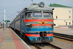
Kupiansk is divided into three subparts, known as: Kupyansk-Gorod (main part of town), Kupiansk-Vuzlovyi (where the train station is), and Kivsharivka.
The train station is a border station between Ukraine and Russia.
Kupyansk-Gorod is about 2 1/2 hours from Kharkiv. There are connections by train or bus.
References
- ↑ "Чисельність наявного населення України (Actual population of Ukraine)" (in Ukrainian). State Statistics Service of Ukraine. Retrieved 26 August 2017.
External links
![]()
| Raions | |||||
|---|---|---|---|---|---|
| Cities |
| ||||
| |||||