Ivanovo, Pančevo
| Ivanovo Иваново Sándoregyháza | |
|---|---|
| Village | |
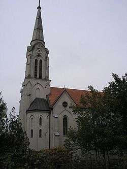 Roman Catholic Church Saint Wendelin | |
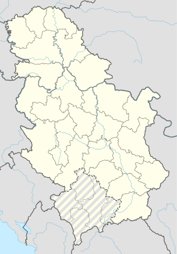 Ivanovo Location of Ivanovo within Serbia | |
| Coordinates: 44°44′11″N 20°42′03″E / 44.73639°N 20.70083°ECoordinates: 44°44′11″N 20°42′03″E / 44.73639°N 20.70083°E | |
| Country | Serbia |
| Province | Vojvodina |
| District | South Banat |
| Municipalities | Pančevo |
| Local community | Ivanovo |
| Population (2011) | |
| • Ivanovo | 1,053 |
| Time zone | UTC+1 (CET) |
| • Summer (DST) | UTC+2 (CEST) |
| Postal code | 26233 |
| Area code(s) | +381(0)13 |
| Car plates | PA |
Ivanovo (Serbian Cyrillic: Иваново; Hungarian: Sándoregyháza; Bulgarian: Иваново; German: Alexanderkirchen) is a village located in the Pančevo municipality, in the southeastern South Banat District of the Vojvodina, Serbia. The village has a population numbering 1,053 people who are permanent residents (2011 census).
Name
The place name means Ivan's location. A legend tells about a Bulgarian man called Ivan who was the first settler of this place. The Hungarian and the German name also mean location of Alexander's church. Both names refer to Sándor Bonnaz, Bishop of Csanád. He protected the building of the church before his death. The church has been built from 1889 to 1899.[1][2]
Location
Ivanovo is located in the southern part of the Town of Pančevo, administrative unit in the South Banat District, and south of its administrative center, Pančevo itself. Village of Omoljica, also part of Pančevo, is just to the northwest, upstream the Nadela. Across the Danube is the village of Ritopek, in the municipality of Grocka, which is part of the City of Belgrade.[3][4]
Geography
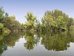
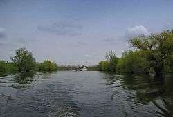
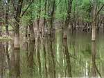
Ivanovo is situated at the mouth of the channeled Nadela river into the Danube's arm of Dunavac. The village is situated among the floodplains of the Danube: Ponjavica on the east, which has been declared a nature park, and Ivanovačko Ostrvo, on the south, which has been declared a natural monument. Ivanovačko ostrvo occupies the river island (ada) of Ivanovo, just south of the village, which has been formed by the Nadela, Dunavac and Danube, at its 1.137 km (0.706 mi).[3][4]
The village is almost from all sides encircled by the rivers and canals (Veliki kanal, etc.), giving an island feel.[5] The section along the Dunavac and the Danube itself is protected by an embankment.[3]
Ivanovo is located in the vast Banat plain, surrounded by the pastures and the groves of poplar and black locust. Along the village, the avenues of walnut trees and lindens are planted.[5]
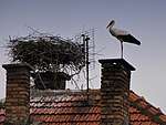
The waters around the village are a natural spawning area of common carp, so the fishing is quite developed, though mostly a recreational one. The surrounding floodplains are inhabited by storks, herons, swans, geese and ducks.[5]
History
The village was founded in 1868[5] and it is the youngest settlement of this administrative area. It was settled by Banat Bulgarians (Paulicians), Germans and Hungarian (Székelys of Bukovina).
Ivanovo is founded in connection with the communal works which were planned for the area. They included the vast melioration, mostly draining of the floodplains in order to obtain arable land. Other project was prevention of the flooding and construction of the embankment along the Danube's bank.[5]
The settlement was a part of Habsburg's military frontier (Austrian Empire) since its founding, then it belonged to the Torontál county of Austria-Hungary. After World War I, that area was a part of provisional Torontalsko-tamiške županja (Treaty of Trianon), in 1922 of Belgrade oblast and since 1929 of the Danube Banovina in the Kingdom of Yugoslavia. In the time after World War II its belonged to the Srez Pančevo of the Socialist Federal Republic of Yugoslavia and of the Federal Republic of Yugoslavia. The communal area of Ivanovo was a part of the municipal region of Pančevo from all these centuries to the present.
In 1944, Red Army troops which participated in the final expulsion of the German occupational forces from Serbia were stationed in and around Ivanovo, including Marshal Fyodor Tolbukhin.[5]
In 2010s, families from Belgrade and Pančevo began buying old houses and renovating them into the summer houses so Ivanovo serves as an air spa and excursion place for the population of the nearby polluted cities.[5]
Characteristics
Though fairly small, the village has cultural venues, elementary school founded in 1888 and today named "Moša Pijade", community health center and post office. There is a Roman Catholic church in Ivanovo, dedicated to Wendelin of Trier, and in 2018 it was announced that an Orthodox church will be built, too.[5]
In the center of the village, a cannon was put on display. The cannon was used by the Red Army during the 1944 to expel the Germans.[5]
Demography
| Historical population | ||
|---|---|---|
| Year | Pop. | ±% p.a. |
| 1921 | 2,271 | — |
| 1931 | 2,299 | +0.12% |
| 1948 | 2,169 | −0.34% |
| 1953 | 2,196 | +0.25% |
| 1961 | 2,066 | −0.76% |
| 1971 | 1,893 | −0.87% |
| 1981 | 1,947 | +0.28% |
| 1991 | 1,439 | −2.98% |
| 2002 | 1,131 | −2.17% |
| 2011 | 1,053 | −0.79% |
| Source: [6][7][8] | ||
| Year | Total | Hungarians | Banat Bulgarians | Germans | Serbs | Other nationalities |
|---|---|---|---|---|---|---|
| 1880 | 724 | 8.14% | 64.36% | 22.23% | 5.27% | |
| 1910 | 2,530 | 51.93% | 30.15% | 16.75% | 0.51% | 0.66% |
| 1948 | 2,169 | 61.31% | 34.80% | 0.46% | 1.56% | 1.87% |
| 2002 | 1,131 | 39.96% | 27.14% | 0.35% | 19.71% | 12.84% |
Economy
Prior to World War II, the arm of the Danube served as a winter shelter (zimovnik) for ships during the harsh winters when the river would freeze, and as an occasional port. Until some time after the war, there was a regular ferry service to Ritopek, across the Danube. A buttons factory "Inga" was operational from 1948 to 1962.[5]
In the 21st century, the settlement is almost completely agricultural, while a number of denizens is employed in Pančevo. Due to the meadows which surround it, and the groves of black locust, the area is suitable for beekeeping.[5]
In the center of the village there is a restaurant, today called Bife Aurelija, which has been working since 1870.[5]
Apart from the road which connects it to Omoljica, across the bridge over Nadela, Ivanovo can be reached from Ritopek, via a seasonal ferry.[5]
Culture
In 2001, local Bulgarian people have formed the cultural association Ivanovo 1868.[9]
Numerous festivities are held in the local cultural venue, including the annual International salon of art photography.[5]
Gallery
|

See also
References
- ↑ Crkva Sveti Vendelin Ivanovo on the Official Website by Diocese of Zrenjanin (in Serbian), Retrieved on 2017-01-01.
- ↑ Sándor Bonnaz on the Website by Catholic Hierarchy (in English), Retrieved on 2017-01-02.
- 1 2 3 Slobodan Radovanović (2007). Belgrade and surrounding places. Smederevska Palanka: Magic Map. ISBN 978-86-7802-004-9.
- 1 2 Turističko područje Beograda. Geokarta. 2007. ISBN 86-459-0099-8.
- 1 2 3 4 5 6 7 8 9 10 11 12 13 14 Miroslav Stefanović (20 May 2018). "Село у којем се слушта тишина" [Village in which you listen to the silence]. Politika-Magazin, No. 1077 (in Serbian). pp. 20–21.
- ↑ Final results of the census of population from 31 January 1921, page 354. Kingdom of Yugoslavia - General State Statistics, Sarajevo. June 1932.
- ↑ Final results of the census of population from 31 March 1931, page 54. Kingdom of Yugoslavia - General State Statistics, Belgrade. 1937.
- ↑ Comparative overview of the number of population in 1948, 1953, 1961, 1971, 1981, 1991, 2002 and 2011 – Data by settlements, page 29. Statistical Office of the Republic of Serbia, Belgrade. 2014. ISBN 978-86-6161-109-4.
- ↑ Decenija KUD Ivanovo 1868, article on the Website by RTV Pančevo, Retrieved on 2017-01-13.
Sources
- Samu Borovszky, Magyarország vármegyéi és városai. Torontal vármegye, Budapest 1912.
External links
- Ivanovo on the Official Website by the Municipality of Pančevo.