Irvine Spectrum
_12.jpg) "Giant Wheel" at the Irvine Spectrum Center as seen from across I-5 | |
| Location | Irvine, California, US |
|---|---|
| Opening date | November 22, 1995 |
| Developer | The Irvine Company |
| Architect |
Perkowitz & Ruth (Phase 1) RTKL Associates (Phase 2) B.A.R. Architects (Phase 3) Unknown Architect ( phases 4-6) |
| No. of stores and services | 152 |
| No. of anchor tenants | 2 |
| Website | http://www.irvinespectrumcenter.com/ |
The Irvine Spectrum Center is an outdoor shopping center developed by the Irvine Company, located on the southeast edge of Irvine, California, US. It is currently the only bit of urbanization connecting the Mission Viejo/San Juan Capistrano/San Clemente area to the rest of the Irvine/Los Angeles/San Bernardino conurbation. The mall features an Edwards 21-screen movie theater.[1] Built over a 10-year period, the first phase of the center opened in 1995 and the second phase followed in 1998. The third phase was completed in 2002. The fourth and fifth phases were built and completed between 2005 and 2006. The mall is used for establishing shots of the fictional "Mall of Miami" in the Disney Channel television series Austin and Ally.
History
_23.jpg)
Planning of the development of the area began in 1985. In 1989, the Irvine Company completed two 15-story office towers at the site. The retail and entertainment portion of the development, then known as the "Entertainment Center at the Irvine Spectrum Center", began construction in 1993. This first phase of the mall opened in 1995 and consisted of Edwards Cinemas' 21-screen multiplex, Oasis Food Court, and GameWorks.[2] The second phase opened in 1998. The mall's carousel was added in 2001. In 2002, the mall's third phase opened, adding a "Giant Wheel" Ferris wheel, and the centers two anchor stores, Robinsons-May and Nordstrom. Robinsons-May was re-branded as Macy's in 2006 after it was bought by Macy's. Another expansion opened in 2006, adding Target as a third anchor. Smaller expansions have been added since, such as the Clock Court restaurants and a children's play area. 2016 saw the completion of 200 Spectrum Center, an office tower on the northwestern edge of the property, designed by Pei Cobb Freed & Partners. At 323 feet tall, 200 Spectrum Center is the tallest building in Orange County.[3] Since 2003, a skating rink has been offered during the winter months, adjacent to the Giant Wheel. Macy's closed its store at the mall in 2016.
Edwards Cinemas
The 21-screen movie theater was once the largest movie theater in the western United States. During development, the Edwards company code-named it "The Big One". This remained the movie theater's nickname for a while thereafter until other theaters eclipsed its screen count, particularly 30-screen AMC Theatres megaplex at The Outlets at Orange. The theater bore over two miles of pink and purple neon lights.
Expansion
The Irvine Company announced in 2016 that the former Macy's building will be torn down and turned into 20 new stores, to be open in 2018 .[4]
Design
_18.jpg)
_09.jpg)
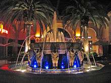
The unusual architecture of the property is based on the Alhambra in Granada, Spain, figuring most prominently in the center's second phase.[3]
A white obelisk, which at night features the word "SPECTRUM" vertically projected onto it, is located on the northern corner near the freeway. It contains a cell phone and television tower.
The Irvine Spectrum Center has a Ferris wheel called Giant Wheel crafted in Italy, as well as a carousel fabricated in San Francisco.
References
- ↑ "Irvine Spectrum Center Movies". Irvine Spectrum Center. Retrieved 28 November 2016.
- ↑ Huffstetter, P.J. (22 June 1998). "Game for a Fresh Look". The Los Angeles Times. Retrieved February 10, 2016.
- 1 2 http://www.summerinspain.net/stuff-to-see-and-do/alhambra/
- ↑ Chan, Alex (7 January 2016). "Macy's at Irvine Spectrum Center to close and be replaced by 20 new stores" – via LA Times.
Coordinates: 33°39′01″N 117°44′37″W / 33.650378°N 117.743504°W