Inverness railway station
| Inverness | |
|---|---|
| Scottish Gaelic: Inbhir Nis[1] | |
 Inverness railway station | |
| Location | |
| Place | Inverness |
| Local authority | Highland |
| Coordinates | 57°28′48″N 4°13′23″W / 57.4800°N 4.2230°WCoordinates: 57°28′48″N 4°13′23″W / 57.4800°N 4.2230°W |
| Grid reference | NH667454 |
| Operations | |
| Station code | INV |
| Managed by | Abellio ScotRail |
| Owned by | Network Rail |
| Number of platforms | 7 |
|
Live arrivals/departures, station information and onward connections from National Rail Enquiries | |
| Annual rail passenger usage* | |
| 2012/13 |
|
| 2013/14 |
|
| 2014/15 |
|
| – Interchange | 72,055 |
| 2015/16 |
|
| – Interchange |
|
| 2016/17 |
|
| – Interchange |
|
| History | |
| Original company | Inverness and Nairn Railway |
| Pre-grouping | Highland Railway |
| Post-grouping | LMS |
| 5 November 1855 | Opened |
| National Rail – UK railway stations | |
| * Annual estimated passenger usage based on sales of tickets in stated financial year(s) which end or originate at Inverness from Office of Rail and Road statistics. Methodology may vary year on year. | |
|
| |
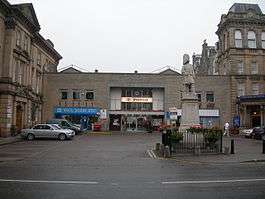
Inverness railway station is the railway station serving the Scottish city of Inverness.
History
Opened on 5 November 1855[2] as the western terminus of the Inverness and Nairn Railway[3] to designs by the architect, Joseph Mitchell.[4] The station originally comprised a single covered passenger platform 200 feet (61 m) with three lines of rails, one for arrivals, one for departures and a spare line for carriages.
In 1857 the railway company erected a clock in front of the station facing Academy Street. This clock by Bryson & Sons, Princes Street, Edinburgh, was illuminated at night.[5]
In 1865 the station was enlarged. The platform was lengthened to 300 feet (91 m) and a shed added which was 300 feet (91 m) long, 51 feet (16 m) wide and 20 feet (6.1 m) high. There were double lines for north and south traffic.[6]
The platforms were extended again to 500 feet (150 m) and the platform roofs were extended in 1876 by Murdoch Paterson. The station platforms were lit by electricity for the first time in 1908.[7]

In 1933, as part of an internal reorganization, the London and North Eastern Railway closed their offices at the station and the staff relocated to Aberdeen.[8]
Between 1966 and 1968 under British Rail the station buildings were replaced, the new design by Thomas Munro and Company.
It is now the terminus of the Highland Main Line, the Aberdeen-Inverness Line (of which the Inverness and Nairn Railway is now a part), the Kyle of Lochalsh Line and the Far North Line.
A revamp by Mott Macdonald of the station's frontage, forecourt and concourse is planned to be completed by 2018.[9]
Stationmasters
- G.H. Critchley 1863 - 1888
- William Forbes 1888 - 1898[10] formerly stationmaster at Grantown railway station
- Colin Mackay 1898[11] - 1919, formerly stationmaster at Grantown railway station
- Frank MacPhail 1919[12] - 1931, formerly station master at Elgin railway station
- William Macleod 1931 - 1938
- James Donaldson 1938 - 1940
- John A. MacRae 1942[13] - 1956
Description
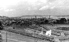
Inverness approaches | ||||||||||||||||||||||||||||||||||||||||||||||||||||||||||||||||||||||||||||||||||||||||||||||||
|---|---|---|---|---|---|---|---|---|---|---|---|---|---|---|---|---|---|---|---|---|---|---|---|---|---|---|---|---|---|---|---|---|---|---|---|---|---|---|---|---|---|---|---|---|---|---|---|---|---|---|---|---|---|---|---|---|---|---|---|---|---|---|---|---|---|---|---|---|---|---|---|---|---|---|---|---|---|---|---|---|---|---|---|---|---|---|---|---|---|---|---|---|---|---|---|---|
| ||||||||||||||||||||||||||||||||||||||||||||||||||||||||||||||||||||||||||||||||||||||||||||||||
Inverness is owned by Network Rail. However, it is operated by Abellio ScotRail who run most of the services using the station. Caledonian Sleeper and London North Eastern Railway run the only non-ScotRail services.
The station itself sits at one apex of a triangular junction in the centre of Inverness, with each half of the station connected to one line. The Highland Main and Aberdeen Lines both approach the station from the east and use Platforms 1–4, while the Far North Line (which also carries traffic heading for the Kyle Line) approach from the north-west and use Platforms 5–7. Platform 5 also has a connection from the east side, but it is only usable by a two car train, and even then, it must not be in passenger service and movements from Platform 5 to the east line are not allowed. Platform 1 is long enough for a 13-coach train; platform 2 can hold 15 coaches; platforms 3 and 4, eight each; and platforms 5–7 will accommodate five coaches each.[14]
A single parliamentary train is run along the third chord of the triangle each weekday, as part of a through Kyle-Elgin service, which runs across the chord before reversing into the station. In the 2013 timetable, this is currently the 17:14 Kyle-Elgin service.
The third chord runs between Rose Street Junction on the Far North Line and Welsh's Bridge Junction on the Aberdeen/Perth line. The Aberdeen and Perth lines diverge at Millburn Junction a short distance beyond Welsh's Bridge. Platforms 1–4 are 118 miles 3 chains (190.0 km) from Perth (measured via Carrbridge); Millburn Junction, 117 miles 37 chains (189.0 km) from Perth, is also 143 miles 39 chains (230.9 km) from Perth (measured via Dava). The station is the zero point for the Far North Line, and platforms 5–7 are 2 chains (40 m) along this line; Rose Street Junction, 18 chains (360 m) along the Far North Line, is 118 miles 1 chain (189.9 km) from Perth.[14] Signalling for the entire area is controlled from a panel box near the station built in 1988. This supervises the station area & approaches and also houses the Radio Electronic Token Block (RETB) control desk that monitors the full length of the Kyle & Far North lines. RETB was installed by British Rail.
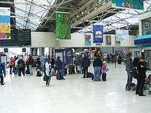
Platform destination LED screens are installed, along with a main departures and arrivals information board. Each of Platforms 1-7 has its own screen showing departures from that platform. Screens are also present behind the wall for all platforms from 3-6. In addition, several other screens are also visible for general information.
Services
Air
Stagecoach North Scotland route 11 runs every 30 minutes between Inverness city centre and Inverness Airport. The bus leaves from Strothers Lane, just around the corner from the station. Journey time to the airport is 25 minutes.
Bus
The main coach and bus station is located in Margaret Street, 150 m northwest of and just around the corner from the railway station. Many services can also be joined at the stop on Millburn Road outside Marks and Spencer, closer to the station.
Aside from local buses, there are also long-distance coach services which allow rail passengers to continue their journey to areas of the Highlands not on the rail network:
- Scottish Citylink route 961 operates two daily return services to Ullapool to connect with Caledonian MacBrayne ferry sailings to Stornoway on the Isle of Lewis. (Rail passengers may also connect with this bus at Garve on the Kyle of Lochalsh line, but the timings are not so convenient.)
- Scottish Citylink route 919 operates six daily return services down the Great Glen to Fort William, calling at Urquhart Castle, Fort Augustus and intermediate points. Two of these services allow onward connections with Citylink route 918 from Fort William to Oban.
Rail
Current services
As of May 2016:
- 7 trains per day to Edinburgh Waverley via Perth.[15]
- 4 trains per day to Glasgow Queen Street.
- 11 trains per day to Aberdeen - one of these continues to Edinburgh via Dundee. An additional evening service runs to Elgin (which operates through from the Kyle line).[16]
- 12 trains per day (13 on Fridays and Saturdays) via Dingwall, of which:
- 4 trains per day to Wick and Thurso.
- 4 trains per day to Kyle of Lochalsh.
- Other services terminate at Invergordon, Tain or Ardgay.[17]
- 1 daytime train per day to London King's Cross via, Falkirk Grahamston, Edinburgh, Newcastle and York (the "Highland Chieftain").[18]
- 1 sleeper train per day to London Euston via Preston and Crewe (the Highland Caledonian Sleeper - doesn't operate on Saturday nights).[19]
Future planned improvements
From 2018, this station will be one of those to benefit from a package of timetable enhancements to be introduced by Transport Scotland and Scotrail. The current Perth to Inverness timetable will be increased to hourly each way, with trains south of there running on alternate hours to Edinburgh & Glasgow. Journey times will be reduced by 10 minutes to both cities. The service to Nairn, Forres & Elgin will also be enhanced to hourly and some Aberdeen trains extended through to Dundee and beyond.[20]
| Preceding station | Following station | |||
|---|---|---|---|---|
| Aviemore | London North Eastern Railway East Coast Main Line (Highland Chieftain) |
Terminus | ||
| Carrbridge | Abellio ScotRail Highland Line |
Terminus | ||
| Nairn | Abellio ScotRail Aberdeen to Inverness Line |
Terminus | ||
| Terminus | Abellio ScotRail Far North Line Kyle of Lochalsh Line |
Beauly | ||
| Aviemore | Caledonian Sleeper Highland Caledonian Sleeper |
Terminus | ||
| Historical railways | ||||
| Culloden Moor Line open; station closed |
Highland Railway Inverness and Aviemore Direct Railway |
Terminus | ||
| Allanfearn Line open; station closed |
Highland Railway Inverness and Nairn Railway |
Terminus | ||
| Terminus | Highland Railway Inverness and Ross-shire Railway |
Clachnaharry Line open; station closed | ||
References
- ↑ Brailsford 2017, Gaelic/English Station Index.
- ↑ Butt (1995)
- ↑ "Opening of the Inverness and Nairn Railway". Inverness Courier. Scotland. 8 November 1855. Retrieved 31 August 2017 – via British Newspaper Archive. (Subscription required (help)).
- ↑ The Buildings of Scotland, Highland and Islands. John Gifford. Yale University Press. 1992. ISBN 0-300-09625-9
- ↑ "Inverness Railway Station". Nairnshire Telegraph and General Advertiser for the Northern Counties. Scotland. 22 April 1857. Retrieved 31 August 2017 – via British Newspaper Archive. (Subscription required (help)).
- ↑ "Inverness Railway Station Extensions and Improvements". Inverness Courier. Scotland. 8 June 1865. Retrieved 31 August 2017 – via British Newspaper Archive. (Subscription required (help)).
- ↑ "Improvements on Highland Line". DundeeCourier. Scotland. 24 March 1908. Retrieved 31 August 2017 – via British Newspaper Archive. (Subscription required (help)).
- ↑ "Inverness Railway Station Changes". The Scotsman. Scotland. 6 June 1933. Retrieved 31 August 2017 – via British Newspaper Archive. (Subscription required (help)).
- ↑ "Design team for Inverness Station revamp". BBC News. 10 March 2017. Retrieved 31 August 2017.
- ↑ "Retirement of Inverness stationmaster". Dundee Advertiser. Scotland. 10 June 1898. Retrieved 30 August 2017 – via British Newspaper Archive. (Subscription required (help)).
- ↑ "Appointment of Inverness stationmaster". Aberdeen Press and Journal. Scotland. 7 July 1898. Retrieved 30 August 2017 – via British Newspaper Archive. (Subscription required (help)).
- ↑ "New Stationmaster for Inverness". Dundee Evening Telegraph. Scotland. 11 September 1919. Retrieved 30 August 2017 – via British Newspaper Archive. (Subscription required (help)).
- ↑ "Larbert Stationmaster for Inverness". Falkirk Herald. Scotland. 4 July 1942. Retrieved 30 August 2017 – via British Newspaper Archive. (Subscription required (help)).
- 1 2 Brailsford 2017, map 18B.
- ↑ GB eNRT May 2016 Edition, Table 229
- ↑ GB eNRT May 2016 Edition, Table 240
- ↑ GB eNRT May 2016 Edition, Table 239
- ↑ GB eNRT May 2016 Edition, Table 26
- ↑ GB eNRT May 2016 Edition, Table 403
- ↑ "‘Rail revolution’ means 200 more services and 20,000 more seats for Scots passengers" Archived 2016-08-20 at the Wayback Machine.Transport Scotland press release 15 March 2016; Retrieved 18 August 2016
Sources
- Brailsford, Martyn, ed. (December 2017) [1987]. Railway Track Diagrams 1: Scotland & Isle of Man (6th ed.). Frome: Trackmaps. ISBN 978-0-9549866-9-8.
- Butt, R. V. J. (1995). The Directory of Railway Stations: details every public and private passenger station, halt, platform and stopping place, past and present (1st ed.). Sparkford: Patrick Stephens Ltd. ISBN 978-1-85260-508-7. OCLC 60251199.
- Jowett, Alan (March 1989). Jowett's Railway Atlas of Great Britain and Ireland: From Pre-Grouping to the Present Day (1st ed.). Sparkford: Patrick Stephens Ltd. ISBN 978-1-85260-086-0. OCLC 22311137.
- Jowett, Alan (2000). Jowett's Nationalised Railway Atlas (1st ed.). Penryn, Cornwall: Atlantic Transport Publishers. ISBN 978-0-906899-99-1. OCLC 228266687.
External links
| Wikimedia Commons has media related to Inverness railway station. |