Kyle of Lochalsh railway station
| Kyle of Lochalsh | |
|---|---|
| Scottish Gaelic: Caol Loch Aillse[1] | |
.jpg) Kyle of Lochalsh station | |
| Location | |
| Place | Kyle of Lochalsh |
| Local authority | Highland |
| Coordinates | 57°16′48″N 5°42′50″W / 57.2800°N 5.7138°WCoordinates: 57°16′48″N 5°42′50″W / 57.2800°N 5.7138°W |
| Grid reference | NG762271 |
| Operations | |
| Station code | KYL |
| Managed by | Abellio ScotRail |
| Number of platforms | 2 |
|
Live arrivals/departures, station information and onward connections from National Rail Enquiries | |
| Annual rail passenger usage* | |
| 2012/13 |
|
| 2013/14 |
|
| 2014/15 |
|
| 2015/16 |
|
| 2016/17 |
|
| History | |
| Original company | Highland Railway |
| Pre-grouping | Highland Railway |
| Post-grouping | LMS |
| 2 November 1897 | Opened[2] |
| National Rail – UK railway stations | |
| * Annual estimated passenger usage based on sales of tickets in stated financial year(s) which end or originate at Kyle of Lochalsh from Office of Rail and Road statistics. Methodology may vary year on year. | |
|
| |
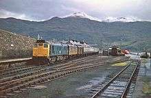
Kyle of Lochalsh railway station is the terminus of the Kyle of Lochalsh Line in the village of Kyle of Lochalsh in the Highlands, northern Scotland.
The station is 63 miles 64 chains (102.7 km) from Dingwall, and has two platforms which can each accommodate a nine-coach train.[3]
History
.jpg)
The station was opened on 2 November 1897[4] by the Highland Railway, following the completion of the extension of the Dingwall and Skye Railway from Stromeferry. The extension took more than four years to complete due to the unforgiving nature of the terrain through which it was driven - 29 bridges had to be constructed and more than 30 cuttings excavated through solid rock, which led to it costing £20,000 per mile[5] (making it the most expensive rail route to be built in the UK at the time). As built, the station consisted of a broad island platform on a pier next to the water's edge and a chalet-style station building close to the western end. Access to the station was (and still is) via a sloping access road. Several sidings were provided, along with a signal box and small locomotive shed.[6]
Until the early 1970s, the station provided a connection to the ferry services for the Outer Hebrides. The ferry terminal at the Kyle of Lochalsh was 71 miles from Stornoway, and Ross and Cromarty council created a new £460,000 (equivalent to £6,529,800 in 2016)[7] ferry terminal at Ullapool which was only 43 miles from Stornoway.[8]
The signal box closed in 1984, when Radio Electronic Token Block working was introduced on the line by British Rail - although no longer operational it is still intact and has been adapted for use as a holiday cottage.[9] Both platforms however remain, though only the western face (platform 1) is normally used by passenger trains. Three sidings are also still intact, including a run-round loop for loco-hauled trains alongside platform 1 and a loading bank siding adjacent to this (which has seen use by timber trains in recent years). Access to each of the sidings and platform 2 is by means of ground frames.[10]
The station is located next to the piers that used to offer sailings to Skye, the ferries being superseded on 16 October 1995 by the Skye Bridge that lies close to the station.
Services
There are four daily departures from the station to Dingwall and Inverness during the week and either one (winter) or two (summer) services on Sundays.[11]
| Preceding station | Following station | |||
|---|---|---|---|---|
| Duirinish | Abellio ScotRail Kyle of Lochalsh Line |
Terminus | ||
References
Notes
- ↑ Brailsford 2017, Gaelic/English Station Index.
- ↑ Butt (1995), page 137
- ↑ Brailsford 2017, map 22D.
- ↑ "Railways in the Western Highlands. Opening of New Kyle Extension". Glasgow Herald. British Newspaper Archive. 3 November 1897. Retrieved 15 August 2016 – via British Newspaper Archive. (Subscription required (help)).
- ↑ The Kyle Line - History www.kylerailway.co.uk; Retrieved 2013-010-08
- ↑ Railscot - Kyle of Lochalsh www.railbrit.co.uk; Retrieved 2013-10-08
- ↑ UK Retail Price Index inflation figures are based on data from Clark, Gregory (2017). "The Annual RPI and Average Earnings for Britain, 1209 to Present (New Series)". MeasuringWorth. Retrieved 6 November 2017.
- ↑ "Ross and Cromarty council vote. Ullapool is Ferry Terminal". Aberdeen Press and Journal. Scotland. 22 October 1970. Retrieved 25 November 2017 – via British Newspaper Archive. (Subscription required (help)).
- ↑ The Kyle Line - Signal Box Holiday Apaprtment www.kylerailway.co.uk; Retrieved 2013-10-08
- ↑ Scot Rail - RETB Inverness www.scot-rail.co.uk; Retrieved 2013-10-08
- ↑ GB eNRT May 2016 Edition, Table 239 (Network Rail)
Sources
- Awdry, Christopher (1990). Encyclopaedia of British Railway Companies. Sparkford: Patrick Stephens Ltd. ISBN 1-8526-0049-7. OCLC 19514063. CN 8983.
- Brailsford, Martyn, ed. (December 2017) [1987]. Railway Track Diagrams 1: Scotland & Isle of Man (6th ed.). Frome: Trackmaps. ISBN 978-0-9549866-9-8.
- Butt, R. V. J. (1995). The Directory of Railway Stations: details every public and private passenger station, halt, platform and stopping place, past and present (1st ed.). Sparkford: Patrick Stephens Ltd. ISBN 978-1-85260-508-7. OCLC 60251199.
- Jowett, Alan (March 1989). Jowett's Railway Atlas of Great Britain and Ireland: From Pre-Grouping to the Present Day (1st ed.). Sparkford: Patrick Stephens Ltd. ISBN 978-1-85260-086-0. OCLC 22311137.
- Jowett, Alan (2000). Jowett's Nationalised Railway Atlas (1st ed.). Penryn, Cornwall: Atlantic Transport Publishers. ISBN 978-0-906899-99-1. OCLC 228266687.
- RailScot: Kyle of Lochalsh Extension (Highland Railway)
- RailScot: Dingwall and Skye Railway
External links
| Wikimedia Commons has media related to Kyle of Lochalsh railway station. |