Interstate 265
| ||||||||||||
|---|---|---|---|---|---|---|---|---|---|---|---|---|
|
Gene Snyder Freeway Lee H. Hamilton Highway | ||||||||||||
_map_B.svg.png) | ||||||||||||
| Route information | ||||||||||||
| Maintained by Indiana DOT and KYTC | ||||||||||||
| Existed | 1977 – present | |||||||||||
| Indiana segment | ||||||||||||
| Length | 6.73 mi[1] (10.83 km) | |||||||||||
| West end |
| |||||||||||
| East end |
| |||||||||||
| Kentucky segment | ||||||||||||
| Length | 24.48 mi[1] (39.40 km) | |||||||||||
| West end |
| |||||||||||
| Major junctions |
| |||||||||||
| North end |
| |||||||||||
| Highway system | ||||||||||||
| ||||||||||||

Interstate 265 (I-265) is a currently two-sectioned Interstate Highway which forms part of a highway ringing the Louisville, Kentucky, metropolitan area, which includes Southern Indiana. In Kentucky, it travels through Jefferson County, from I-65 in the southern part of Louisville to I-71, where it continues north temporarily signed as KY 841 until reaching the Lewis and Clark Bridge. In Indiana, the highway continues west temporarily signed as SR 265, until reaching I-65, where the road continues west to I-64 as I-265, where it ends.
The entire Kentucky stretch of the road is co-signed with Kentucky Route 841 (KY 841). The highway is named the Gene Snyder Freeway (originally named the Jefferson Freeway), after the former congressman, and usually called "the Snyder" by locals. It is considered part of Louisville's beltline.
On December 18, 2016, State Road 265 was extended east of State Road 62, which crosses the Ohio River connecting with KY 841, which was extended north of U.S. 42 in Kentucky as part of the Ohio River Bridges Project, creating a bypass around the eastern side of the city of Louisville.
Route description
| mi[1] | km | |
|---|---|---|
| IN | 6.73 | 10.83 |
| KY | 24.48 | 38.40 |
| Total | 31.21 | 50.23 |
Indiana
Interstate 265 (I-265) in the U.S. state of Indiana presently runs 6.94 miles (11.17 km)[2] from I-64 at the western edge of New Albany to I-65 in Clarksville. From that point east, the freeway continues as Indiana State Road 265, pending approval from the American Association of State Highway and Transportation Officials (AASHTO) to sign it as I-265 now that it connects to the Kentucky portion of that Interstate highway. INDOT lists the official length of I-265 as slightly longer — 0.21 miles (0.34 km) — than the distance the FWHA records.[2][1]
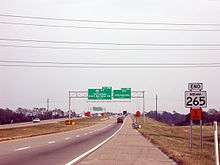
Indiana State Road 265 (SR 265) is a four-lane, Interstate standard divided freeway that runs 6.17 miles (9.93 km) west-to-east from I-65 at I-265 to the Lewis and Clark Bridge (part of the Ohio River Bridges Project) over the Ohio River. This freeway was always intended to become an extension of I-265 when the connection to Kentucky was completed, though as of the bridge opening, the highway is still signed as "State Road 265", with the exception of a couple of mile-marker signs with the designation of I-265. The entire 7-mile Indiana segment of I-265 and the first 3 miles of Indiana State Road 265 run concurrently with SR 62.
Lewis and Clark Bridge
In various discussions for over 30 years, the Lewis and Clark Bridge (previously referred to as the East End Bridge) is part of a new 6.5-mile (10.5 km) highway that connects State Road 265 in Indiana to KY 841 in Kentucky. The completion of the bridge connected the two disjointed highways to form a three-quarter beltway around the Louisville, Kentucky, metro area. The bridge was opened to traffic on December 18, 2016. However, the new stretch of highway is not yet signed as "I-265". The Indiana segment is currently signed only as Indiana State Road 265, while the Kentucky segment is signed only as KY 841, meaning there are still two separate sections of I-265 as opposed to one continuous section from I-65 in Kentucky to I-64 in Indiana. There are currently no plans to construct a bridge on the west end of I-265.
Kentucky
Kentucky Route 841 (KY 841) is a 38.8-mile-long (62.4 km) state highway in the suburbs of Louisville. The route is a partial beltway, encircling Louisville on its southern and eastern sides. The western terminus of the route is at U.S. Route 31W (US 31W) and US 60 in the southwest Louisville community of Valley Station, where KY 841 continues to the west as KY 1934. The eastern terminus is at the Lewis and Clark Bridge.
KY 841 and I-265 overlap for 24.477 miles (39.392 km) between I-65 exit 125 and I-71 exit 9.
The Gene Snyder Freeway, from I-65 to I-71 has seen an increase in serious accidents. The primary factors stem from its low-level grass median which offers little to no protection for crossover incidents. Driver inattention and increased traffic and congestion has led to a decline in the overall level-of-service. In 2006, cable barriers were installed in the median for 10 miles (16 km) between I-71 and I-64, with further installation possible in the near future.[3]
History
Originally signed just as KY 841, the Jefferson Freeway was constructed originally with two sections, one between KY 155 (Taylorsville Road) and US 60 (Shelbyville Road) and a second section between KY 1447 (Westport Road) and US 42 in the 1960s as short connectors to the eastern suburban expansion as well as a new Ford plant. I-264 by 1970 was woefully congested and was in dire need of reconstruction and other improvements, therefore I-265 was proposed as an outer beltway to provide pass-through motorists relief from the congestion of I-264. Construction started in the early 1980s and was finished later that decade and signed in 1987.
The road is signed I-265 from the I-65 interchange to the I-71 interchange. From I-65 west to US 31W (although it is up to Interstate Highway standards) and I-71 north/west to the Lewis and Clark Bridge, is signed as KY 841 due to American Association of State Highway and Transportation Officials numbering rules. KY 841 is signed throughout the entire designation of I-265. The exit numbering for the entire beltway starts at the western terminus of KY 841.
Studies have also been conducted for the reconfiguration of the I-265 and I-64 interchange. It is currently an underpowered cloverleaf with no collector–distributor lanes, a relic of the original Jefferson Freeway.
In late 2005, members of the Louisville Metro Council proposed a committee to begin planning a western bridge to link the southwestern end of the highway in Kentucky to Indiana. However the proposal of the western bridge was not put into action yet.
Exit list
| State | County | Location | mi | km | Exit | Destinations | Notes |
|---|---|---|---|---|---|---|---|
| Kentucky | Jefferson | Louisville | 0.0 | 0.0 | 1 | Western terminus of KY 841. Continues as KY 1934 past this exit | |
| 3.1 | 5.0 | 3 | Stonestreet Road | ||||
| 6.0 | 9.7 | 6 | New Cut Road | ||||
| 7.7 | 12.4 | 8 | |||||
| 10.2 | 16.4 | 10 | I-65 exit 125; west end of I-265; signed as exits 10A (north) and 10B (south) westbound | ||||
| 11.7 | 18.8 | 12 | |||||
| 13.5 | 21.7 | 14 | Smyrna Road | ||||
| 15.2 | 24.5 | 15 | |||||
| 17.3 | 27.8 | 17 | |||||
| 19.4 | 31.2 | 19 | |||||
| 23.1 | 37.2 | 23 | |||||
| Middletown | 25.5 | 41.0 | 25 | I-64 exit 19; signed as exits 25A (east) & 25B (west). | |||
| 26.8 | 43.1 | 27 | |||||
| Louisville | 28.7 | 46.2 | 29 | Old Henry Road | |||
| 30.4 | 48.9 | 30 | |||||
| 32.5 | 52.3 | 32 | |||||
| 34.0 | 54.7 | 34 | |||||
| 34.7 | 55.8 | 35 | I-71 exit 9; north end of I-265; signed as exits 35A (east) & 35B (west) | ||||
| Prospect | 37.0 | 59.5 | 37 | Northbound exit and southbound entrance only | |||
| Louisville East End Tunnel | |||||||
| Ohio River | 38.9 13.11 | 62.6 21.10 | Lewis and Clark Bridge (Opened December 18, 2016); at state line – north end of KY 841, east end of SR 265 | ||||
| Indiana | Clark | Utica | 11.81 | 19.01 | 11 | International Drive/Old Salem Road - River Ridge | Opened December 18, 2016 |
| Jeffersonville | 9.63 | 15.50 | 10 | East end of SR 62 overlap; double roundabout exit also provides access to/from Port Street | |||
| 6.94 | 11.17 | 7 | I-65 exit 6; west end of IN 265; signed as exits 7A (north) and 7B (south) westbound | ||||
| Floyd | New Albany | 4.52 | 7.27 | 4 | Charlestown Road | ||
| 3.35 | 5.39 | 3 | Grant Line Road | ||||
| 0.97 | 1.56 | 1 | State Street | ||||
| 0.00 | 0.00 | 0 | I-64 exit 121; western terminus; westbound exit and eastbound entrance; both ramps are signed as exit 0 | ||||
1.000 mi = 1.609 km; 1.000 km = 0.621 mi
| |||||||
See also
References
- 1 2 3 4 Adderly, Kevin (January 27, 2016). "Table 2: Auxiliary Routes of the Dwight D. Eisenhower National System of Interstate and Defense Highways as of December 31, 2015". Route Log and Finder List. Federal Highway Administration. Retrieved December 8, 2016.
- 1 2 "INDOT Reference Post Book - July 2015" (PDF). Indiana Department of Transportation. Retrieved December 25, 2016.
- ↑ Hogan, Doug (January 20, 2006). "Governor Fletcher & Kentucky Transportation Cabinet Move Forward with Safety Measures for Interstate Highways: Median Cable Barriers to Be Installed at Two Jefferson County Locations" (Press release). Kentucky Transportation Cabinet. Archived from the original on September 27, 2006.
External links
Route map: