Iasmos
| Iasmos Ίασμος | |
|---|---|
 | |
 Iasmos Location within the region 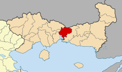 | |
| Coordinates: 41°08′N 25°11′E / 41.133°N 25.183°ECoordinates: 41°08′N 25°11′E / 41.133°N 25.183°E | |
| Country | Greece |
| Administrative region | East Macedonia and Thrace |
| Regional unit | Rhodope |
| Area | |
| • Municipality | 485.3 km2 (187.4 sq mi) |
| • Municipal unit | 221.8 km2 (85.6 sq mi) |
| Elevation | 43 m (141 ft) |
| Population (2011)[1] | |
| • Municipality | 13,810 |
| • Municipality density | 28/km2 (74/sq mi) |
| • Municipal unit | 5,703 |
| • Municipal unit density | 26/km2 (67/sq mi) |
| Community[1] | |
| • Population | 4,399 (2011) |
| Time zone | UTC+2 (EET) |
| • Summer (DST) | UTC+3 (EEST) |
| Vehicle registration | ΚΟ |
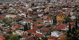
Iasmos (Greek: Ίασμος, Turkish: Yassıköy) is a town and a municipality in the Rhodope regional unit of Thrace, Greece. It is built on the side of the Rhodope Mountains. Although references about the village date back to the 16th Century, it is likely that those references are about the old location of the village, a few kilometres west of the current position. The actual date that the inhabitants settled in the current place is between the late 18th century and 1814 (the latter date is inscribed on the wall of the oldest church in the village).
Municipality
The municipality Iasmos was formed at the 2011 local government reform by the merger of the following 3 former municipalities, that became municipal units:[2]
The municipality has an area of 485.285 km2, the municipal unit 221.795 km2.[3]
References
- 1 2 "Απογραφή Πληθυσμού - Κατοικιών 2011. ΜΟΝΙΜΟΣ Πληθυσμός" (in Greek). Hellenic Statistical Authority.
- ↑ Kallikratis law Greece Ministry of Interior (in Greek)
- ↑ "Population & housing census 2001 (incl. area and average elevation)" (PDF) (in Greek). National Statistical Service of Greece. Archived from the original (PDF) on 2015-09-21.
Administrative division of the Eastern Macedonia and Thrace Region | ||
|---|---|---|
| Regional unit of Drama | 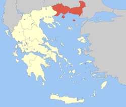 | |
| Regional unit of Evros | ||
| Regional unit of Kavala | ||
| Regional unit of Rhodope | ||
| Regional unit of Thasos | ||
| Regional unit of Xanthi | ||
| ||