Myki, Greece
| Myki Μύκη | |
|---|---|
 Municipality of Myki | |
 Myki Location within the region 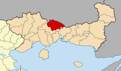 | |
| Coordinates: 41°15′N 24°55′E / 41.250°N 24.917°ECoordinates: 41°15′N 24°55′E / 41.250°N 24.917°E | |
| Country | Greece |
| Administrative region | East Macedonia and Thrace |
| Regional unit | Xanthi |
| Government | |
| • Mayor | Mustafa Aga |
| Area | |
| • Municipality | 633.3 km2 (244.5 sq mi) |
| • Municipal unit | 314.9 km2 (121.6 sq mi) |
| Elevation | 499 m (1,637 ft) |
| Population (2011)[1] | |
| • Municipality | 15,540 |
| • Municipality density | 25/km2 (64/sq mi) |
| • Municipal unit | 12,087 |
| • Municipal unit density | 38/km2 (99/sq mi) |
| Community[1] | |
| • Population | 8,051 (2011) |
| Time zone | UTC+2 (EET) |
| • Summer (DST) | UTC+3 (EEST) |
| Vehicle registration | AH |
Myki (Greek: Μύκη, Bulgarian: Мустафчово, Mustafčovo) is a municipality in the Xanthi regional unit, Greece. The seat of the municipality is in Sminthi.[2] The majority of the population in the municipality are Pomaks.[3]
Municipality
The municipality Myki was formed at the 2011 local government reform by the merger of the following 4 former municipalities, that became municipal units:[2]
The municipality has an area of 633.334 km2, the municipal unit 314.874 km2.[4] The population of the municipal unit Myki was 12,087 as of 2011.[1] The main villages of the municipal unit are Sminthi, Alma, Glafki, Kentavros, Myki, Echinos, Melivoia and Oraio.
References
- 1 2 3 "Απογραφή Πληθυσμού - Κατοικιών 2011. ΜΟΝΙΜΟΣ Πληθυσμός" (in Greek). Hellenic Statistical Authority.
- 1 2 Kallikratis law Greece Ministry of Interior (in Greek)
- ↑ http://www.odigosxanthis.gr/touristikos-odigos/axiotheata/pomakoxoria
- ↑ "Population & housing census 2001 (incl. area and average elevation)" (PDF) (in Greek). National Statistical Service of Greece.
Administrative division of the Eastern Macedonia and Thrace Region | ||
|---|---|---|
| Regional unit of Drama | 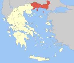 | |
| Regional unit of Evros | ||
| Regional unit of Kavala | ||
| Regional unit of Rhodope | ||
| Regional unit of Thasos | ||
| Regional unit of Xanthi | ||
| ||
This article is issued from
Wikipedia.
The text is licensed under Creative Commons - Attribution - Sharealike.
Additional terms may apply for the media files.