Houpt, Minnesota
| Houpt, Minnesota | |
|---|---|
| Unincorporated community | |
 Houpt, Minnesota Location of the community of Houpt within Nore Township, Itasca County  Houpt, Minnesota Houpt, Minnesota (the US) | |
| Coordinates: 47°48′02″N 94°23′29″W / 47.80056°N 94.39139°WCoordinates: 47°48′02″N 94°23′29″W / 47.80056°N 94.39139°W | |
| Country | United States |
| State | Minnesota |
| County | Itasca |
| Township | Nore Township |
| Elevation | 1,394 ft (425 m) |
| Population | |
| • Total | 30 |
| Time zone | UTC-6 (Central (CST)) |
| • Summer (DST) | UTC-5 (CDT) |
| ZIP code | 56630 and 56661 |
| Area code(s) | 218 |
| GNIS feature ID | 656664[1] |
Houpt is an unincorporated community in Nore Township, Itasca County, Minnesota, United States; located in the northwest corner of the county.
The community is located between Northome and Blackduck at the intersection of U.S. Highway 71 and Bowman Road. The South Cormorant River flows through the community. Nearby places include Funkley, Northome, Blackduck, Orth, Bergville, and Alvwood.
Houpt is located 7 miles southwest of Northome; and 9 miles northeast of Blackduck. Houpt is 15 miles northwest of Alvwood; and 52 miles northwest of Deer River. The boundary line between Itasca, Beltrami, and Koochiching counties is nearby.
ZIP codes 56630 (Blackduck) and 56661 (Northome) meet near Houpt. A post office previously operated in the community of Houpt from 1903 to 1914.
References
- Mn/DOT map of Itasca County – Sheet 2 – 2011 edition
Municipalities and communities of Itasca County, Minnesota, United States | ||
|---|---|---|
| Cities | 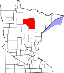 | |
| Townships |
| |
| Unorganized territories | ||
| CDPs | ||
| Unincorporated communities | ||
| Indian reservations | ||
| Footnotes | ‡This populated place also has portions in an adjacent county or counties | |