Horstmar
| Horstmar | ||
|---|---|---|
| ||
 Horstmar Location of Horstmar within Steinfurt district 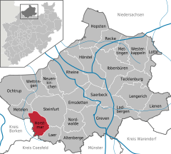  | ||
| Coordinates: 52°04′50″N 7°18′30″E / 52.08056°N 7.30833°ECoordinates: 52°04′50″N 7°18′30″E / 52.08056°N 7.30833°E | ||
| Country | Germany | |
| State | North Rhine-Westphalia | |
| Admin. region | Münster | |
| District | Steinfurt | |
| Government | ||
| • Mayor | Robert Wenking (CDU) | |
| Area | ||
| • Total | 45 km2 (17 sq mi) | |
| Elevation | 77 m (253 ft) | |
| Population (2016-12-31)[1] | ||
| • Total | 6,402 | |
| • Density | 140/km2 (370/sq mi) | |
| Time zone | CET/CEST (UTC+1/+2) | |
| Postal codes | 48612 | |
| Dialling codes | 02558 | |
| Vehicle registration | ST | |
| Website | www.horstmar.de | |


Street view of Saint Gertrude Church
Horstmar is a German city, located in North Rhine-Westphalia in the Steinfurt district, approx. 25 km (16 mi) north-west of Münster.
History
Its castle was built as early as the 9th century; the first mention of Horstmar is as early as the early 11th century. The city of Horstmar was built to the south of this castle. During the Thirty Years' War the castle was destroyed by order of the Hessian lieutenant Carl von Rabenhaupt.
Politics
The city council consists of 22 councillors and the mayor.
References
- ↑ "Amtliche Bevölkerungszahlen" (in German). Landesbetrieb Information und Technik NRW. Retrieved 2018-02-24.
Towns and municipalities in Steinfurt (district) | ||
|---|---|---|
This article is issued from
Wikipedia.
The text is licensed under Creative Commons - Attribution - Sharealike.
Additional terms may apply for the media files.