Hörstel
| Hörstel | ||
|---|---|---|
| ||
 Hörstel Location of Hörstel within Steinfurt district 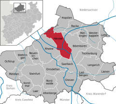  | ||
| Coordinates: 52°17′50″N 7°35′10″E / 52.29722°N 7.58611°ECoordinates: 52°17′50″N 7°35′10″E / 52.29722°N 7.58611°E | ||
| Country | Germany | |
| State | North Rhine-Westphalia | |
| Admin. region | Münster | |
| District | Steinfurt | |
| Government | ||
| • Mayor | David Ostholdhoff (SPD) | |
| Area | ||
| • Total | 107.32 km2 (41.44 sq mi) | |
| Elevation | 145 m (476 ft) | |
| Population (2016-12-31)[1] | ||
| • Total | 20,038 | |
| • Density | 190/km2 (480/sq mi) | |
| Time zone | CET/CEST (UTC+1/+2) | |
| Postal codes | 48477 | |
| Dialling codes | 05454,05459,05978 | |
| Vehicle registration | ST | |
| Website | www.hoerstel.de | |

![]()
Gallery
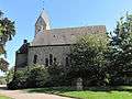 Hörstel, church: die Friedenskirche
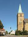 Hörstel, church: katholische Pfarrkirche Sankt Antonius
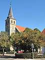 Riesenbeck, church: Sankt Kalixtus Kirche
References
- ↑ "Amtliche Bevölkerungszahlen" (in German). Landesbetrieb Information und Technik NRW. Retrieved 2018-02-24.
Towns and municipalities in Steinfurt (district) | ||
|---|---|---|
| Authority control |
|---|
This article is issued from
Wikipedia.
The text is licensed under Creative Commons - Attribution - Sharealike.
Additional terms may apply for the media files.