Sipsey Fork of the Black Warrior River
| Sipsey Fork | |
|---|---|
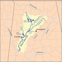 Sipsey Fork within the Black Warrior Basin | |
| Country | United States |
| Physical characteristics | |
| Main source | 34°19′21″N 87°28′20″W / 34.32259°N 87.47224°W |
| River mouth | 33°48′56″N 87°03′26″W / 33.81566°N 87.05722°WCoordinates: 33°48′56″N 87°03′26″W / 33.81566°N 87.05722°W |
| Length | 71-mile-long (114 km) |
| Basin features | |
| River system | Mobile-Tensaw |
| Type | Wild, Scenic |
| Designated | October 28, 1988 |
The Sipsey Fork of the Black Warrior River is a 71-mile-long (114 km)[1] river located in Alabama, USA, and is formed by the junction of Thompson and Hubbard creeks in the Sipsey Wilderness of Bankhead National Forest. The Sipsey Fork discharges into the Mulberry Fork.[2] The Sipsey Fork below Smith Lake is one of the few places within the state to catch rainbow trout.
References
- ↑ "The National Map". U.S. Geological Survey. Retrieved Feb 23, 2011.
- ↑ U.S. Geological Survey Geographic Names Information System: Sipsey Fork of the Black Warrior River
This article is issued from
Wikipedia.
The text is licensed under Creative Commons - Attribution - Sharealike.
Additional terms may apply for the media files.